


Snow showers are developing in the mountains ahead of more impactful snowfall Tuesday, according to the forecasters with the National Weather Service in Boulder.
“Temperatures will fall quickly here in town through the day,” Denver7’s Katie LaSalle said. “We’ll start off in the 40s but by 9:30 in the morning, we’re already looking at temperatures falling to the low 30s” as this next storm moves into the area.
Weather service officials said the storm that will be moving from the high country should bring “a decent band of snow” to the Denver metro on top of low-level winds that should generate at least a couple of hours of snowfall from about 8 or 9 a.m. until after the lunch hour.
Below, you can find updates related to traffic and weather as the storm moves through Tuesday. Refresh this page for the latest. If reading this in the Denver7 mobile app, click here for the latest updates.
MORE: Hourly forecast | Latest forecast | Radars | Traffic | Weather Page | 24/7 Weather Stream
Stream live, current temperatures plus radars across Colorado anytime for free on the free Denver7+ app on your TV or watch from your computer or mobile phone anytime.

Tuesday, Feb. 27
1:48 p.m. | ROAD REOPENS | Peña Boulevard has reopened after an earlier crash.
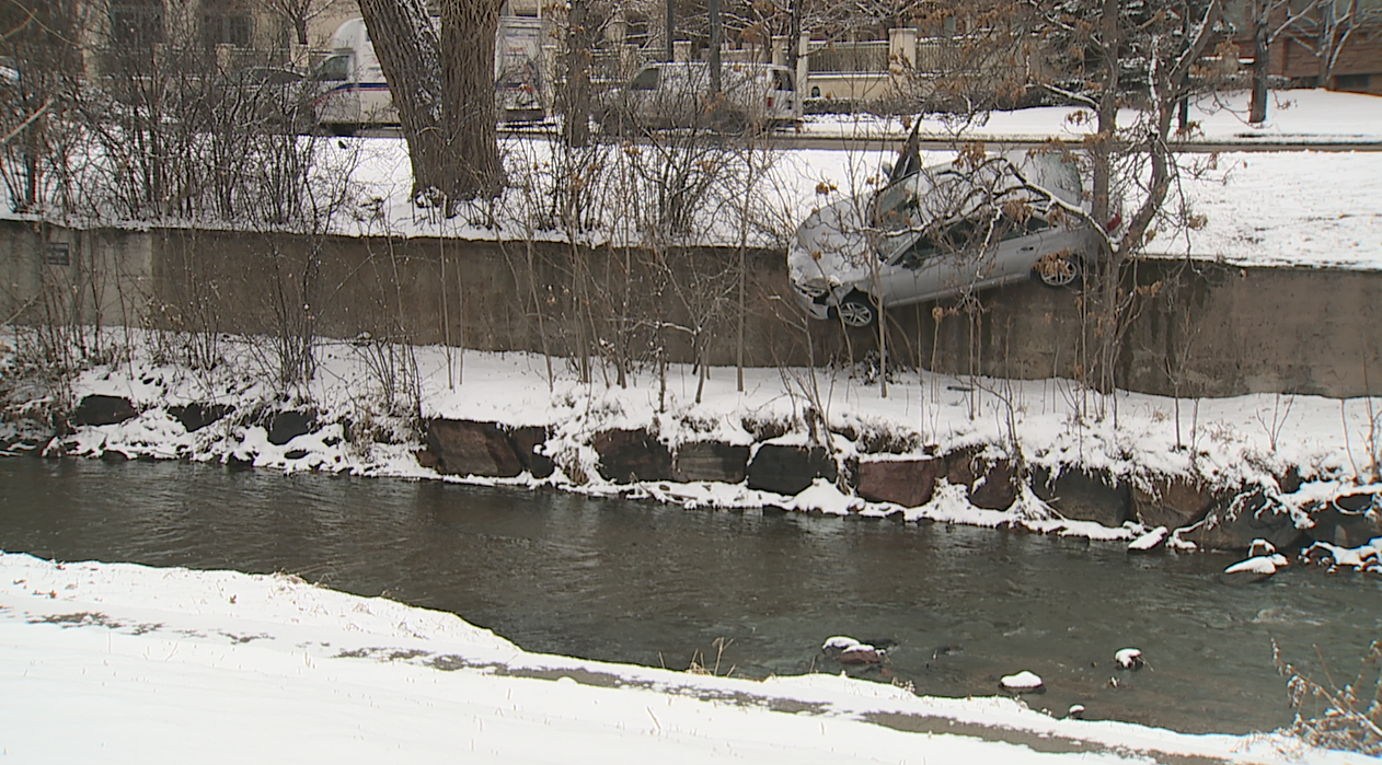
11:15 a.m. | VEHICLE CRASH | Denver police responded to a single-vehicle crash on Speer Boulevard at Grant Street around 10 a.m. The vehicle slid off the Speer and down an embankment, coming to a rest halfway down an embankment wall along the Cherry Creek Trail. There were no injuries.
10:49 a.m. | ROAD REOPENS | Highway 93 reopened about an hour after a multi-vehicle crash Tuesday, the Jefferson County Sheriff's Office posted on the social media site X.
All #OPEN on HWY 93. Be safe out there. https://t.co/bSYQTxBh9o
— Jeffco Sheriff (@jeffcosheriffco) February 27, 2024
10:45 a.m. | ROAD CLOSURE | Eastbound and westbound U.S. Route 6 are closed between Mile Point 222 and I-70, according to CDOT.
Hazmat vehicles are staging at Eisenhower Tunnel and will run at the top of the hour or as traffic allows, CDOT said.
#US6 eastbound/westbound: Safety closure between Mile Point 222 and I-70; Loveland Pass. Hazmat vehicles are to stage at Eisenhower Tunnel and will be run at the top of the hour or as traffic allows. https://t.co/DKhfyuBEiW
— Colorado Department of Transportation (CDOT) (@ColoradoDOT) February 27, 2024
10:31 a.m. | SNOW SQUALL WARNING | A snow squall warning is in effect until 11:00 a.m. for I-70 and U.S. Route 36 near Byers, Colorado and I-70 near Deer Trail, Colorado, NWS Boulder said. I-70 and U.S. Route 36 near Peoria, Colorado and I-70 near Strasburg, Colorado also is under a warning.
A snow squall warning is in effect until 11:00 AM MST for I-70, US-36 near Byers, CO and I-70 near Deer Trail, CO and I-70, US-36 near Peoria, CO and I-70 near Strasburg, CO. #COwx pic.twitter.com/zymJkEj8pM
— NWS Boulder (@NWSBoulder) February 27, 2024
10:12 a.m. | SNOW SQUALL WARNING | A snow squall warning is in effect until 10:45 a.m. for I-25, U.S. Route 85 near Denver and Aurora, Colorado, NWS Boulder posted on the social media site X.
A snow squall warning is in effect until 10:45 AM MST for I-25, US-85 near Denver--Aurora, CO. #COwx pic.twitter.com/nMrofaPQZJ
— NWS Boulder (@NWSBoulder) February 27, 2024
10:00 a.m. | AIRPORT DELAYS | Denver International Airport is seeing delays of 15 minutes on average with arriving flights facing poor braking conditions due to ice, according to a Federal Aviation Administration notice.
"They will still accept arrivals but space them out more and give them, more space to slow down," Denver7 Traffic Expert Jayson Luber said.
9:59 a.m. | VEHICLE PILE-UP | If you're traveling to Denver International Airport, beware of a vehicle pile-up on Peña Boulevard, the airport posted on the social media site X. Expect delays, DIA recommended, as traffic is diverted onto Tower Road.
Heads up drivers! 🚗
— Denver Int'l Airport (@DENAirport) February 27, 2024
If you’re leaving DEN, there is a vehicle pile up on Peña. Expect delays.
⚠️ Drive with caution as the roads are wet. pic.twitter.com/MUn1Bxe4ev
9:58 a.m. | DOWNED LIGHT POLE | There's a downed light pole on the South Platte River Trail south of Frog Hollow Park, near I-25, according to Denver Parks & Recreation.
Please be aware of a downed light pole on the South Platte River Trail south of Frog Hollow Park, adjacent to I-25. Appropriate crews have been notified & are working to resolve the issue. In addition, use extra caution on all trails & walkways during today's snowy weather.
— Denver Parks & Recreation (@denverparksrec) February 27, 2024
"Crews have been notified and are working to resolve the issue. In addition, use extra caution on all trails and walkways during today's snowy weather," Denver Parks & Rec. said.
9:46 a.m. | ROAD CLOSURE | Colorado State Highway 93 is closed in both directions between 64th Ave. and Colorado State Highway 72 for a multi-vehicle crash, the Jefferson County Sheriff's Office said.
Hey #Jeffco Hwy 93 #CLOSED in both directions between 64th and hwy 72.
— Jeffco Sheriff (@jeffcosheriffco) February 27, 2024
Please be careful out there! Plan accordingly. pic.twitter.com/tI5wGv1QaL
9:40 a.m. | SNOW SQUALL WARNING | A Snow Squall Warning is in effect until 10:30 a.m. for I-70 near Bennett, Colorado and U.S. Route 36 near Byers, Coloradom I-70 near Strasburg, Colorado and I-70 near Watkins, Colorado, according to NWS Boulder.
A snow squall warning is in effect until 10:30 AM MST for I-70 near Bennett, CO and I-70, US-36 near Byers, CO and I-70 near Strasburg, CO and I-70 near Watkins, CO. #COwx pic.twitter.com/cua7jXobj6
— NWS Boulder (@NWSBoulder) February 27, 2024
9:22 a.m. | ROAD CLOSURE | Eastbound I-70 is closed between Georgetown and Empire Junction - between Exit 228 and 232, CDOT said.
#I70 eastbound: Safety closure between Exit 228 - CR 381; Georgetown and Exit 232 - US 40; Empire Junction. https://t.co/e97LqvCNle
— Colorado Department of Transportation (CDOT) (@ColoradoDOT) February 27, 2024
9:10 a.m. | SNOW SQUALL WARNING | A Snow Squall Warning is in effect until 10:00 a.m. for I-25, I-270, I-70, I-225 near Denver and Aurora, Colorado and I-76 near Lochbuie, Colorado and US-85 near Fort Lupton, Colorado, according to NWS Boulder.
A snow squall warning is in effect until 10:00 AM MST for I-25, I-270, I-70, I-225 near Denver--Aurora, CO and I-76 near Lochbuie, CO and US-85 near Fort Lupton, CO. #COwx pic.twitter.com/zDNXrXiGhl
— NWS Boulder (@NWSBoulder) February 27, 2024
9:01 a.m. | ROAD CLOSURE All lanes of southbound Highway 285 at Kennedy Gulch are closed due to a jackknifed semi-truck, the Jefferson County Sheriff's Office said. Please find alternative routes, officers recommended.
Heads up road closure in #Jeffco! All lanes of southbound Hwy 285 at Kennedy Gulch are closed due to a jack-knife semi truck. Please find alternative routes. pic.twitter.com/dPSxVHZpcx
— Jeffco Sheriff (@jeffcosheriffco) February 27, 2024
8:39 a.m. | SNOW SQUALL WARNING | A Snow Squall Warning is in effect until 9:15 a.m., the National Weather Service in Boulder said. The warning encompasses I-225, I-70, I-25, I-270 near Denver and Aurora, Colorado and I-76 near Lochbuie, Colorado and I-25, US-287 near Longmont, Colorado and US-85 near Fort Lupton, Colorado.
A snow squall warning is in effect until 9:15 AM MST for I-225, I-70, I-25, I-270 near Denver--Aurora, CO and I-76 near Lochbuie, CO and I-25, US-287 near Longmont, CO and US-85 near Fort Lupton, CO. #COwx pic.twitter.com/Z7pgitwcDI
— NWS Boulder (@NWSBoulder) February 27, 2024
8:19 a.m. | SNOW SQUALL WARNING | A snow squall warning is in effect until 8:45 a.m., the National Weather Service in Boulder said. This encompasses U.S. Route 36 near Boulder, Colorado and U.S. Route 36 near Denver and Aurora, Colorado and U.S. Route 36 near Lafayette, Louisville and Erie, Colorado.
A snow squall warning is in effect until 8:45 AM MST for US-36 near Boulder, CO and US-36 near Denver--Aurora, CO and US-36 near Lafayette--Louisville--Erie, CO. #COwx pic.twitter.com/2fMa0uCyj0
— NWS Boulder (@NWSBoulder) February 27, 2024
8:03 a.m. | SNOW SQUALL WARNING | A snow squall warning is in effect until 8:45 a.m. for I-76, U.S. Route 138, U.S. Route 6 near Sterling, Colorado, according to NWS Boulder.
A snow squall warning is in effect until 8:45 AM MST for I-76, US-138, US-6 near Sterling, CO. #COwx pic.twitter.com/UQ8x6az2ku
— NWS Boulder (@NWSBoulder) February 27, 2024
7:45 a.m. | ROAD CLOSURE | Eastbound U.S. Route 6 closed between Montezuma Road and Interstate 70, the Colorado Department of Transportation said. Loveland Pass is closed for adverse conditions and low visibility, according to CDOT.
#US6 eastbound: Safety closure between Montezuma Road and I-70; Loveland Pass. Loveland Pass Closed for Adverse Conditions and Low Visability. https://t.co/BbhRlnlWzi
— Colorado Department of Transportation (CDOT) (@ColoradoDOT) February 27, 2024
7:15 a.m. | SNOW SQUALL WARNING | A snow squall warning is in effect until 7:45 a.m. for U.S. Route 85 near Eaton, Colorado and U.S. Route 34 near Greeley, Colorado, forecasters with the National Weather Service in Boulder said.
A snow squall warning is in effect until 7:45 AM MST for US-85 near Eaton, CO and US-34, US-85 near Greeley, CO. #COwx pic.twitter.com/IRq8pYL653
— NWS Boulder (@NWSBoulder) February 27, 2024
6:12 a.m. | TUESDAY MORNING FORECAST | A fast moving front is bringing an abrupt change to Colorado's weather Tuesday. This next storm will continue to bring more heavy snow to the mountains, with light snow and colder conditions on the plains.

Denver7 | Weather
Denver weather: From windy and warm Monday to colder and snowy Tuesday morning
A Winter Storm Warning is in effect from Steamboat to Telluride for up to 2 feet of snow by Tuesday night.
Temperatures will start off in the 40s across the eastern plains and then quickly drop into the 30s by late morning.
Around 1-2 inches of snow accumulation is possible across the plains starting Tuesday morning and then tapering off by the afternoon.
Click here to see Lisa Hidalgo's full forecast
5:31 a.m. | WINTER STORM WARNING | A winter storm warning continues for the mountains above 9,000 feet, the National Weather Service in Boulder said. Expect travel impacts, obey chain laws, and check CDOT early and often for the latest road conditions.
A winter storm warning continues for the mountains above 9,000 feet. Expect travel impacts, obey chain laws, and check https://t.co/uoUwxQYden early and often for the latest road conditions. pic.twitter.com/JCO30Uracl
— NWS Boulder (@NWSBoulder) February 27, 2024
5:16 a.m. | SNOW SQUALL IN LUPTON COUNTY | A snow squall moved across Larimer County Tuesday morning. Expect a burst of heavy snow, gusty winds and rapidly deteriorating travel conditions, the National Weather Service in Boulder said. The snow squall will be about 20 minutes and end around 5:10 a.m., according to NWS forecasters.
Heads up! A Snow squall is moving quickly across Larimer County. Expect a burst of heavy snow, gusty winds, and rapidly deteriorating travel conditions. This radar loop is 20 minutes long ending at 5:10 AM. Blue polygon is the warned area. #cowx pic.twitter.com/3zp2sQLe2z
— NWS Boulder (@NWSBoulder) February 27, 2024