


Saturday morning update:
The snow has moved to the east of Denver, but icy and slippery roads remained a concern Saturday morning. The National Weather Service in Boulder recommended anyone needing to travel Saturday morning allow for extra time.
Ice became an issue across the metro area Friday night. The moisture that moved in began as freezing rain. Since our temperatures never went above freezing on Friday, the moisture just froze right when it hit surfaces across the Front Range. Folks in the Denver area woke up to temps in the teens Saturday morning.
Black ice caused road conditions to deteriorate Friday night and through the overnight hours. Roads were expected to improve Saturday afternoon.
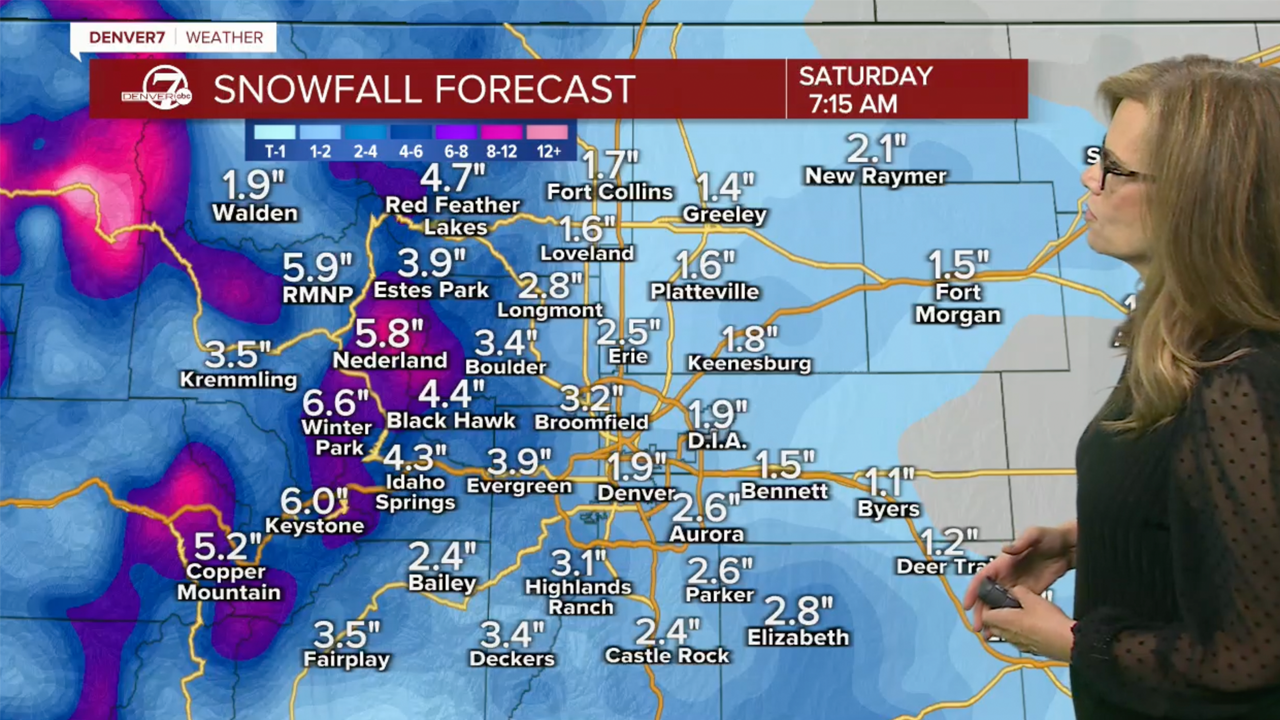
Around two inches of snow fell Friday night into Saturday for much of Denver, with pockets of 3-4 inches in the eastern part of town and near the Palmer Divide, according to NWS snowfall analysis.
A winter weather advisory was in effect for the Denver metro stretching just south to Castle Rock and north all the way through Fort Collins to the Wyoming border until 2 a.m. with icy roads the main concern.
Temperatures will stay below freezing until late Saturday morning, so we will be dealing with the ice and snow throughout Friday night and early Saturday.
Check latest Colorado winter weather alerts at this link
Previous story:
“This is a really fast moving storm, but we are under a winter weather advisory until 2 a.m. for the Front Range,” said Donaldson.
For Colorado’s mountains, the winter weather advisory will remain in effect until 5 a.m. Saturday where bands of heavier snow are possible and could impact travel to Colorado’s ski destinations, the NWS said.
Denver snow timeline
For the metro area and communities north and west along the I-25 corridor, the bulk of the snow is expected to fall late Friday afternoon into the evening hours, specifically between 6 and 10 p.m.
By overnight into Saturday morning, the NWS said weather impacts should lessen as sunny skies and a high temperature of 40 degrees await for Saturday.
The I-70 corridor into the mountains should also see the greatest snow impacts Friday evening, said the NWS.
“Initial snow will be localized heavy snow bands, turning to a light/moderate widespread snow,” said NWS forecasters.
The storm rolls out of Colorado leaving behind sun and warming temperatures for the weekend.
“We’ll have sunny skies all weekend, even for the long weekend we’ll still be around 60 degrees by the time we get to Monday,” said Donaldson.
The warming trend continues into next week with sunny skies and afternoon high temperatures approaching the 60s for Denver.

The February blasts of snow have helped Denver get a little closer to normal seasonal snowfall totals, but the metro is still around 10 inches behind for the year.
So far in the 2023-2024 snow season, Denver's snow gauge at DIA shows 24.6 inches. That amount is still behind the cumulative normal at this point in the year of 34.9 inches.
Halfway through February, Denver is already ahead of what we normally see for the month before Friday's snow arrives.
Denver's February snow totals show 9.2 inches which is ahead of the 7.8 inches normally expected during the entire month.
To view the Denver snowfall statistics infographics in fullscreen mode click this link.

DENVER WEATHER LINKS: Hourly forecast | Radars | Traffic | Weather Page | 24/7 Weather Stream
Click here to watch the Denver7 live weather stream.