


DENVER — Tuesday will bring another day of elevated fire danger to Colorado's Front Range and foothills as the dangerous combination of strong winds, warm temperatures and dry conditions continue this week.
The National Weather Service (NWS) out of Boulder is warning about "near critical," "critical" and "extremely critical" fire weather beginning Tuesday. Several warnings and watches are in place for Tuesday and may be extended through the end of the week.

A red flag warning, which means critical fire weather is either happening or will begin shortly, will go into effect at 10 a.m. Tuesday and last through the early evening for Denver County, Larimer County, Boulder County, Jefferson County, north and west Douglas County, Gilpin County, Clear Creek County, northeast Park County, Weld County, and west Broomfield County.
In some locations, winds are expected to range between 30 and 40 mph, with gusts reaching 80 mph, according to the NWS. Other areas will see the strongest gusts hovering around 45 mph.

Farther south, Pueblo County, Huerfano County, Las Animas County, Crowley County and Otero County will be under a similar warning between 10 a.m. and 6 p.m. Tuesday for winds 15 to 25 mph and gusts up to 35 mph, the NWS reported.
A high wind watch is also impacting several counties — including Jackson County, Grand County and Summit County — from 8 a.m. to 6 p.m. Tuesday.
- DENVER WEATHER LINKS: Hourly forecast | Radars | Traffic | Weather Page | 24/7 Weather Stream
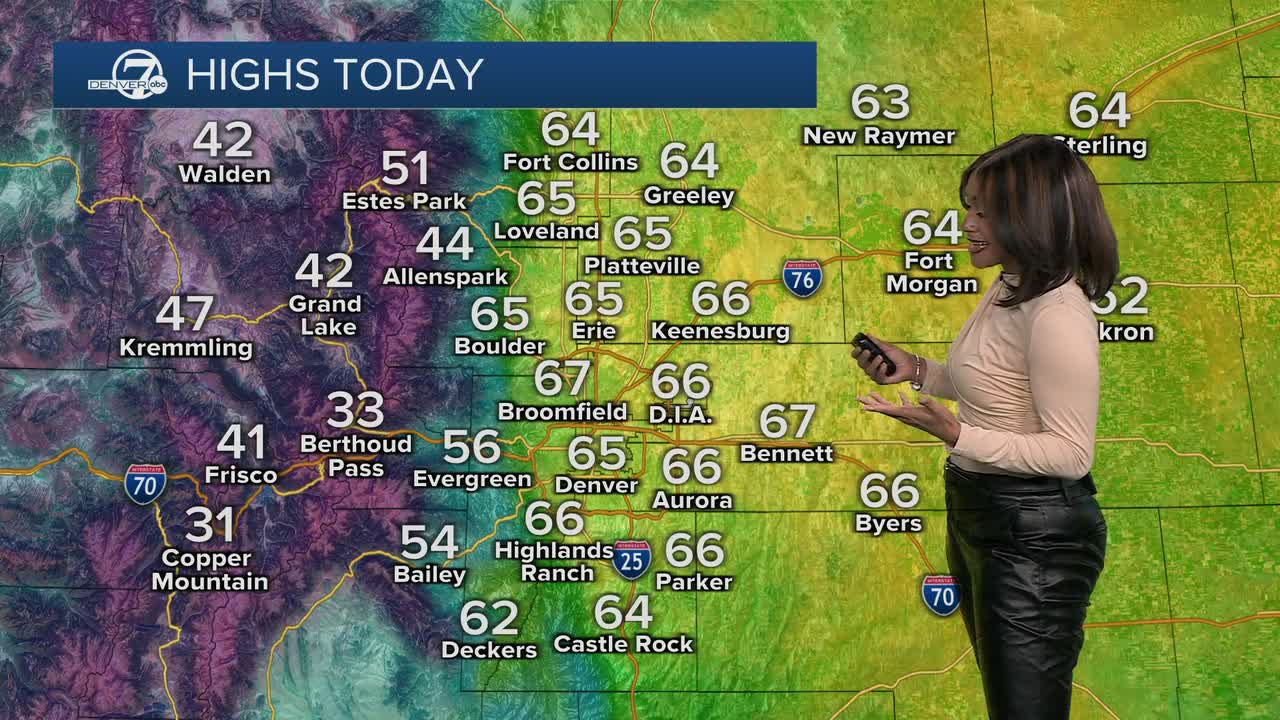
Denver7 Meteorologist Danielle Grant issued a Weather Action Day that will go into effect at 4 p.m. Monday so Coloradans can prepare for this high fire danger across the Front Range on Tuesday.
This fire danger may continue through Friday for the eastern plains, the NWS reported. Windy conditions in general are expected to persist Wednesday, Thursday and Friday, with some gusts reaching 55 mph. The exact locations of the strongest wind gusts is not yet clear, the NWS said, though their models are indicating it will likely stay in northern Colorado.

The chance for snowfall will also return to the mountains on Tuesday, with increasing chances into Wednesday. NWS says that snow totals Tuesday evening through Wednesday evening are expected to stay between 6 and 12 inches for most of the mountains. The Park and Gore ranges may see significantly more — up to 16 inches in spots.
The Colorado Division of Fire Prevention and Control said on Monday that prescribed burning is planned for Tuesday in La Plata County if the weather is acceptable. The department said recent snowfall made this possible. The burn piles are along the Highway 140 corridor along the La Plata River, so drivers on Highways 140 and 160 may see smoke in the area.
This week of fire danger is not uncommon this winter season. Colorado continues to see historically little snowfall and snowpack and high temperatures. Just last week, Denver7 reported on the dual dangers of elevated fire danger on the plains and serious avalanche hazards in the mountains.
That week, we saw a wind-fueled grassfire that burned about 5,000 acres in Lincoln County. That same day, "brown out" conditions due to dust were at least partially to blame for a 36-vehicle pile-up on Interstate 25 south of Pueblo that killed five people.
Avalanche danger is expected to rise this week as well, with an avalanche watch already in place for the northern mountains, especially around and north of Steamboat Springs, according to the Colorado Avalanche Information Center (CAIC). That is the only part of the state that is expected to see "High" danger conditions, which is rated as a 4 out of 5 on CAIC's scale.

"We are carefully monitoring this storm, especially for places like Summit County and the Front Range, where previous storms have not yet pushed the snowpack to its tipping point," CAIC wrote in its forecast. "There is some concern that, due to strong winds and dense snow, areas receiving more than 8 inches — particularly those that have not experienced a recent large avalanche cycle — could see increasingly widespread dangerous conditions."
Colorado has not seen any fatal avalanches this season. As of this time in the 2024-2025 season, three people had died in slides. Two people died within the same timeframe the season prior.
Watch Denver7's 24/7 weather stream in the video player below.


