


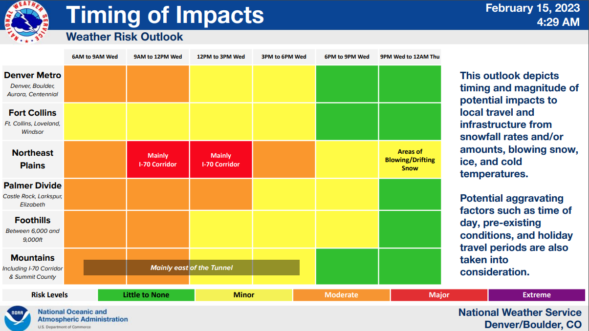
DENVER — Expect snow to continue to fall through the day Wednesday, including during the afternoon commute, as a big winter storm continues to push through the state.
A Winter Storm Warning is in effect for a large part of the state with the heaviest snow falling in the southern foothills and Palmer Divide, including I-25 south of Denver through Colorado Springs, according to The National Weather Service in Boulder.
Denver, Aurora, Boulder and other communities are under a Winter Weather Advisory through Midnight. The NWS said these areas could see an additional 2 to 7 inches of accumulation on top of what has already fallen Wednesday morning.
A Denver7 Weather Action Day is in effect until 10:30 p.m. Wednesday. Refresh this story for updates on the timing and impacts as the storm rolls through Colorado.

TIMELINE
Snow will continue through the afternoon and into the evening hours with temperatures staying in the teens for afternoon highs before overnight lows drop into the single digits.
The additional snow could add up to 3 to 8 inches in Denver, with heavier amounts in the southern suburbs, according to Lisa Hidalgo, Denver7 morning meteorologist.
Overnight tonight, skies will clear out with a few lingering flurries possible tomorrow morning. Thursday, expect a cold day, but calmer conditions with a nice warm up on the way.
SNOW TOTALS (SO FAR)
Denver7 morning meteorologist Lisa Hidalgo said if the storm system moves north by a few miles, it could change Denver’s snowfall forecast. Here’s the projected totals as of Tuesday afternoon.
- SE Wolf Creek Pass: 25"
- W Montrose: 13"
- Silverton: 10.4"
- NNW Golden: 7.6"
- W Boulder: 6.5"
- W Lakewood: 6.2"
Read out complete list of snow totals in Colorado.
LOOKING AHEAD
Meteorologist Hidalgo said the storm system will lift northeast on Wednesday night with clearing skies returning on Thursday. After highs in the upper 20s on Wednesday and lows dipping to the single digits on Thursday morning, sunny and milder conditions return for Friday.
A high of 50 degrees and sunshine returns to end the week with temperatures in the mid 50s Saturday and Sunday. Denver’s next chance of rain and snow is forecasted for Monday of next week.

DENVER SNOW SO FAR THIS SEASON
Nearing the halfway point of the month, Denver has only seen a trace amount of snow compared to 15.8 inches for all of February 2022. But the cumulative total this season has Denver at 36.9 total inches which is ahead of last year by 18.9 inches, not counting the month of February.
The normal snowfall for Denver is 47 inches, according to the NWS. This is for the Denver International Airport reporting station. NWS Boulder points out seasonal snowfall amounts are generally higher in the western suburbs of Denver with an average of 65 inches.
Below is a Denver7 360 In-depth look at a typical February in Colorado with plenty of charts and graphs. If you have trouble seeing it, click this link for a full screen experience.

MORE: Closings and Delays | Latest forecast | Radars | Traffic | Weather Page | 24/7 Weather Stream
You can always watch 24/7 weather, radar and news updates on the free Denver7+ app on your TV.