


DENVER — A weather system that moved into Colorado overnight, bringing much-needed moisture to the state, might be overstaying its welcome after non-stop rain on Monday.
And Mother Nature might have taken the hint as the system begins to weaken as it moves eastward.
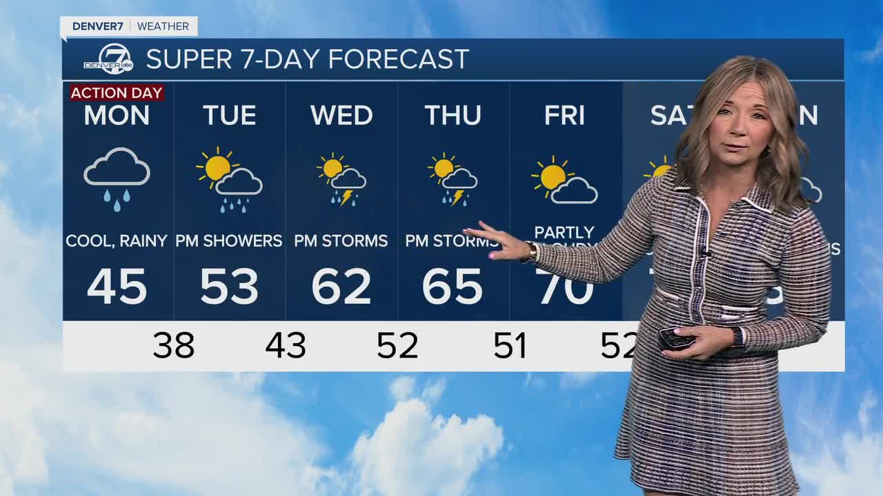
However, light showers may linger along the Front Range past midnight, with rain continuing near the southern foothills by early Tuesday.
But before it completely leaves the area, it has drenched the Front Range and dropped more than two inches of snow in parts of the High Country.
A winter storm warning remains in effect for parts of the north-central mountains, including Rocky Mountain National Park, where it turned the park into a winter wonderland after at least 2.4 inches fell in the area in the past 24 hours.
Park officials are advising guests that snow is sticking to roads and that the vehicle traction law is in effect within the park.
Clouds and higher low‑level moisture tonight should keep most of the Denver and Boulder metro area just above freezing, though areas north and east of Denver may see patchy frost, including the Palmer Divide, where a freeze warning is in effect overnight.
Denver7’s Maggy Wolanske visited Georgetown to see the snowy conditions. Dennis Durham, the town administrator, said these winter conditions are not surprising and are a welcomed sight given the drought conditions.
“Well for our road and bridge team it's not out of the ordinary,” said Durham. “We expect this and we plan for it, so we're not surprised and we do need the precipitation. But we do have spring events coming up like Memorial Day, so we weren't very concerned at this point. We expected all to melt off by then.”
► Watch Maggy Wolanske's report in the player below:
Warmer weather is expected later in the week, the Memorial Day weekend events Durham is talking about are a pancake breakfast on Friday and pack burro races on Saturday.
Nathan Elder, manager of water supply at Denver Water, said this weather will only help a small amount with the drought conditions our state is currently in.
“It's really going to be a huge snowpack next year or severe flooding this summer and we're all going to we're all going to know it,” said Elder. “We're about seven inches behind precipitation wise in our watersheds from the start of the water year in October, so it's really going to take a lot to make up that big deficit.“
With precipitation in the forecast, Elder recommended turning off your sprinkler systems to let ‘Mother Nature do the work for you’ and to look at your landscape to see if you should transition to a plant that is more appropriate for Colorado climate.
Tuesday and Wednesday will stay cool and unsettled with highs in the 50s and isolated late‑day showers or storms near the higher terrain.
By Friday and into next weekend, temperatures should rebound to above normal with much drier weather returning.
MORE: Hourly forecast | Latest forecast | Radars | Traffic | Weather Page | 24/7 Weather Stream
Stream live, current temperatures plus radars across Colorado anytime for free on the free Denver7+ app on your TV or watch from your computer or mobile phone anytime.


