


DENVER — A strong storm system is approaching Colorado triggering Winter storm warnings and advisories in the state beginning Tuesday afternoon and stretching over the next 24 to 36 hours.
A Winter Storm Warning goes into effect at 5 p.m. this afternoon for areas just south of Denver stretching through the southern front range foothills and includes Castle Rock. According to the National Weather Service in Boulder, communities under the warning could see heavy snow between 5 and 10 inches of accumulations.
Denver, Boulder and areas in eastern Adams and Arapahoe counties will be under a Winter Weather Advisory starting at midnight for potential snow accumulations between 3 and 7 inches, the NWS forecasted.
SNOWFALL TIMELINE
Light snow will begin in the mountains Tuesday and move across the plains through the evening and overnight hours into Wednesday, the NWS said.
In Denver, most of the weather impacts shouldn't happen until late evening and into the overnight hours potentially making for a slick Wednesday morning commute.
Denver7 morning meteorologist Lisa Hidalgo said if the storm system moves north by a few miles, it could change Denver’s snowfall forecast.
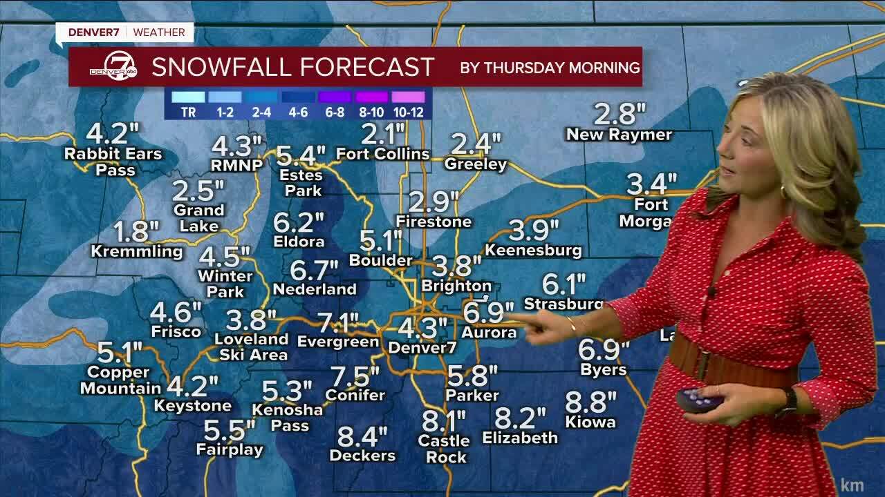
CURRENT POTENTIAL SNOW TOTALS
- Palmer Divide: 6”-10”
- Southern Denver metro: 3”-8”
- Northern metro up to Boulder: 2”-4”
- Northern I-25 to Fort Collins and plains: Trace to 3”
- Telluride: 1 to 2 feet
Heavy snow up to 7 inches is possible in the watch area with wind gusts blowing as high as 50 mph, NWS said. To see all communities under warnings and advisories, click this link to read the latest alerts.
Colorado’s southern mountains could see up to a foot of snow, Hidalgo said.
As for travel conditions, southeast of Denver along I-70 and the I-25 corridor are expected to see the brunt of the snowy conditions, but that could change if the storm moves farther north by a few miles.
Temperatures in Denver on Wednesday will only reach the upper 20s and stay in the single digits for lows by Thursday morning but temps will rebound by the end of the week.
Milder and dry conditions arrive by Friday with a high of 51 degrees expected. A beautiful weekend is shaping up with partly cloudy skies and highs in the mid to upper 50s.
“A lot can change in the next 24 hours, so stay with us, we’re going to keep a close eye on these totals.” said Hidalgo.

DENVER SNOW SO FAR THIS SEASON
Nearing the halfway point of the month, Denver has only seen a trace amount of snow compared to 15.8 inches for all of February 2022. But the cumulative total this season has Denver at 36.9 total inches which is ahead of last year by 18.9 inches, not counting the month of February.
The normal snowfall for Denver is 47 inches, according to the NWS. This is for the Denver International Airport reporting station. NWS Boulder points out seasonal snowfall amounts are generally higher in the western suburbs of Denver with an average of 65 inches.
Below is a Denver7 360 In-depth look at a typical February in Colorado with plenty of charts and graphs. If you have trouble seeing it, click this link for a full screen experience.

MORE: Closings and Delays | Latest forecast | Radars | Traffic | Weather Page | 24/7 Weather Stream
You can always watch 24/7 weather, radar and news updates on the free Denver7+ app on your TV.
Denver7's Robert Garrison contributed to this report.