


DENVER — Denver's potential snow totals for the upcoming powerful winter storm have increased slightly with accumulations of between 8 to 16 inches possible across the metro area.
Denverites are urged to get ready for prolonged, heavy and wet snow to last over an extended period of time with snowfall rates between 1 to 2 inches per hour possible.
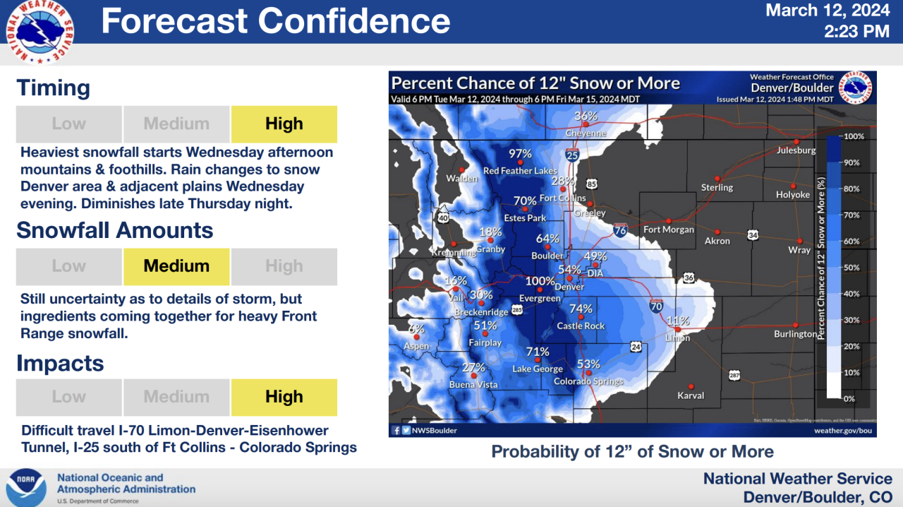
Along with the higher potential snow amounts, a winter storm warning is set to go into effect for the Denver metro starting Wednesday evening as rough travel conditions are expected through the day on Thursday and periods of heavy snow are expected to last between 18 to 24 hours, according to the National Weather Service (NWS) in Boulder.
Localized blizzard conditions are possible but wind gusts were expected to be slightly slower minimizing blowing snow impacts, however, the heavy, wet snow is likely to lead to broken branches and downed power lines and power outages, the NWS said in its Tuesday afternoon update.
"If you don't have to be leaving your house, Thursday is probably not the best day to be out on the roads," said Greg Heavener, NWS Warning Coordination Meteorologist.
While still over 24 hours out from the beginning of the storm impacts and lingering uncertainty to exactly how much snow could fall in Denver and across the state, the NWS said there is "high likelihood" for travel impacts and "tremendous amounts of snow" as this storm is shaping up to be a classic March snowstorm — with March being the snowiest month of the season.
After Tuesday’s warm temps and sunshine, Denver’s weather will transition to rain beginning on Wednesday afternoon before switching over to snow.
Initially, the Denver metro area was under a winter storm watch, but the NWS upgraded the alert to a winter storm warning starting at 9 p.m. Wednesday and lasting through 6 a.m. on Friday for heavy snow accumulating between 9 and 18 inches. The winter storm warning includes the cities of Boulder, all of Denver, Parker, Golden, Arvada, Highlands Ranch, Longmont, Aurora, Littleton, Brighton and Lakewood, among other communities.
Castle Rock will also fall under the winter storm warning for between 14 to 24 inches of snow and wind gusts up to 40 mph, according to the NWS.
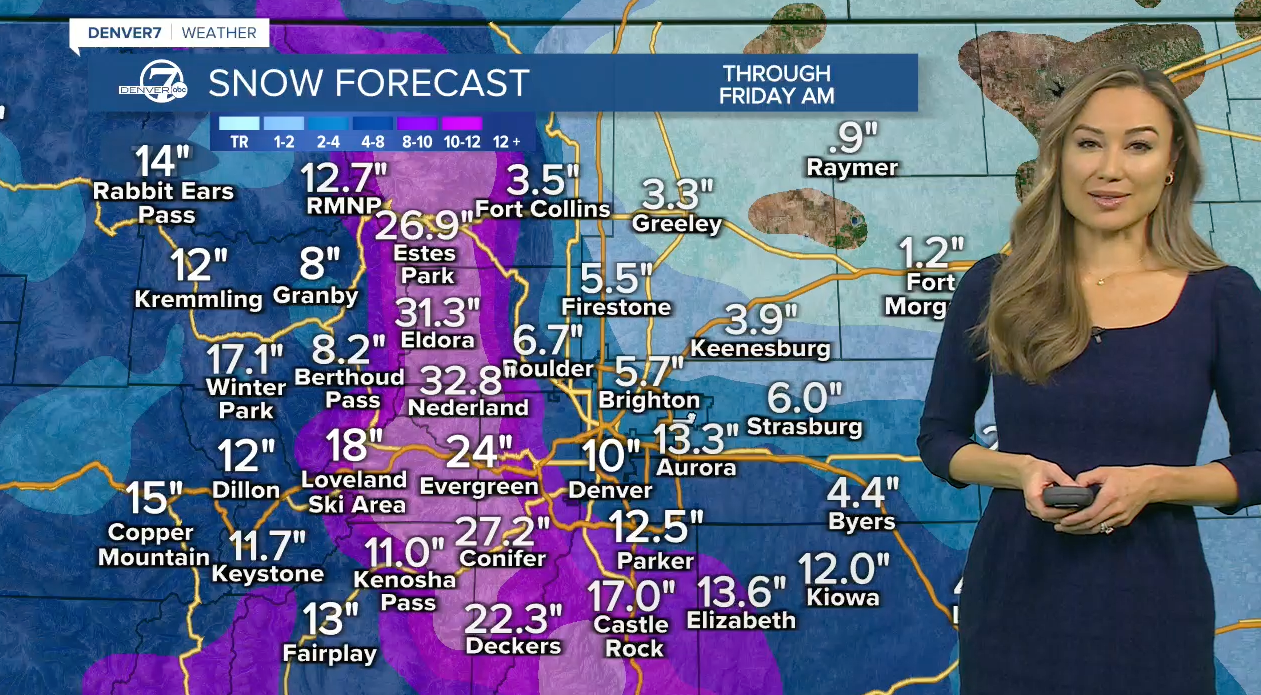
“We could see closer to a foot of snow in Castle Rock and anywhere from one to three feet possible through the northern Front Range mountains and foothills,” said Denver7 Meteorologist Lisa Hidalgo. “So some heavy snow west of Denver, Fort Collins and down through Castle Rock.”
A winter storm warning will go into effect earlier for Colorado's Front Range Mountains and foothills beginning at Noon on Wednesday where the NWS expected snow totals between 18 to 36 inches and "isolated totals up to 48 inches possible."
Even with the potential for heavy snow and high accumulations in the Denver metro and Front Range, weather forecasters expected the heaviest amounts to fall on the eastern slopes of the Front Range.
The cities of Fort Lupton, Fort Collins, Greeley, Loveland, Eaton among other communities will go under a winter storm watch starting Wednesday evening for heavy snow bringing between 4 and 12 inches of accumulation.
Check the latest updated Colorado winter weather alerts at this link.
DENVER WEATHER: SNOW TIMELINE
Rain showers are expected to develop Wednesday afternoon across the Denver area in time for the evening commute.
“Winds shifting out of the northeast with blustery conditions in store throughout the day on Thursday and that rain will switch over to all snow and some areas of heavy snow throughout the day,” said Hidalgo, adding there could be some delays and cancellations on Thursday, “as those snowfall totals look pretty impressive.”
While Wednesday’s weather in Denver is expected to bring mostly rain at first, conditions will switch over to snow and “difficult travel is expected for the Front Range mountains, foothills and I-25 corridor Wednesday night through Thursday night,” said the NWS.
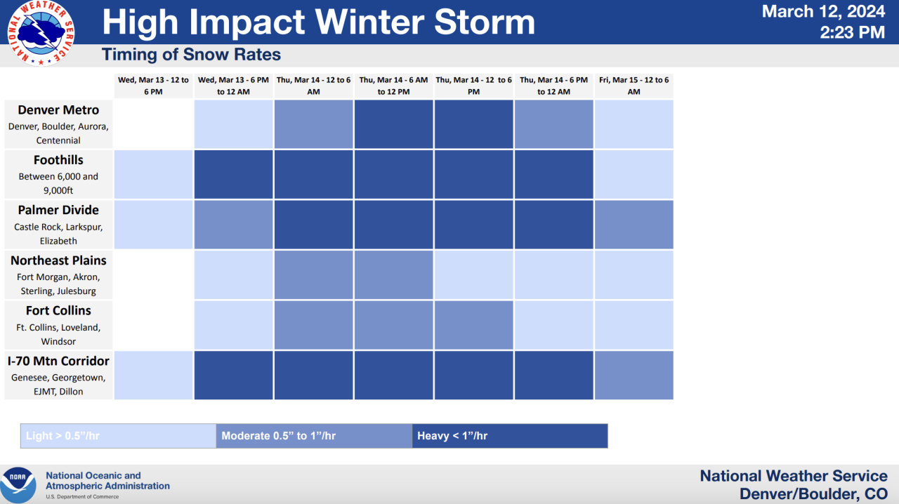
Motorists should be prepared for snow covered roads and treacherous travel along I-70 from Limon to Denver and through the Eisenhower Tunnel as well as along I-25 south of Fort Collins extending all the way down to Colorado Springs, according to the NWS.
The NWS said chances for a big March snowstorm decrease east and northeast from Denver through Colorado's plains.
While this strong storm is expected to drop heavy, wet snow in areas, it is not expected to plunge temperatures well below freezing.
Potential snow totals across Denver metro, Colorado communities
The NWS provides a probabilistic snowfall tool that shows low-end, expected and high-end snowfall accumulations. While the tool is "experimental", the NWS says it can give an overall look at possible snow totals.
Here are potential expected snowfall totals:
- Downtown Denver: 12"
- Denver International Airport: 11"
- Boulder: 16"
- Georgetown: 24"
- Castle Rock: 20"
- Kiowa: 16"
- Winter Park: 32"
- Walden: 7"
- Lakewood: 17"
- Fort Collins: 7"
- Limon: 6"
- Sterling: 1"
- Fort Morgan: <1"
- Fairplay: 13"
- Breckenridge: 12"
- Vail Pass: 15"
- Akron: 2"
- Greeley: 3"
- Alamosa: 7"
- Colorado Springs: 9"
- Durango: 3"
- Pueblo: 2"
- Trinidad: 7"

Local
Denver weather in March: Snowiest month, blizzards and the start of spring
Denver’s 7-day forecast shows Thursday’s morning low dropping to around 28 degrees and the high temperature around 35 degrees.
Friday’s morning low temperature in Denver will be around 27 degrees.
After morning flurries on Friday, skies are expected to clear out through the day and temperatures will slowly begin to rebound.
Saturday and Sunday in Denver, expect a mix of partly cloudy and sunny skies with temperatures warming into the upper 40s before rebounding to nearly 60 degrees and plenty of sunshine by Monday.
Denver's snowfall totals so far this winter season have lagged behind the normal totals, but blasts of February snow have helped the metro rebound.
In February, Denver's official snow reporting station at Denver International Airport recorded 13.7 inches, which is above the 7.8 inches the city normally reports in February. That additional snowfall brought Denver to around 5 inches behind the normal cumulative total for this time in the winter season.
Denver normally sees 11.5 inches of snow in March, according to NWS data, meaning if this storm were to drop 12 inches or more at DIA, the metro could officially hit its monthly normal snowfall total in just one storm.
To view the Denver snowfall statistics infographics in fullscreen mode click this link.
A Denver7 Weather Action Day is set to go into effect Wednesday evening to help you prepare for the storm. More to come!


DENVER WEATHER LINKS: Hourly forecast | Radars | Traffic | Weather Page | 24/7 Weather Stream
Click here to watch the Denver7 live weather stream.