


DENVER — After a round of severe storms dropped large hail, hammering portions of northeastern Colorado early Tuesday morning, the severe weather threat moves closer to the Denver metro area Tuesday afternoon.
A severe thunderstorm watch is in effect for the entire metro and I-25 corridor until 5 p.m. for the threat of large, to very-large hail, isolated tornadoes and wind gusts up to 80 mph.
Severe thunderstorms are already firing up across the Front Range,
The Denver7 news team is tracking the latest Colorado weather alerts and conditions across northeastern Colorado and the Denver metro area.
Refresh this page for updates and keep checking back for new details.
LINKS: Latest forecast | Radars | Traffic | Weather Page | 24/7 Weather Stream
Tuesday, June 17
5:00 p.m. | Severe thunderstorm watch expires | The Denver metro is no longer under a severe thunderstorm watch, which expired at 5 p.m.
Here are the Colorado counties no longer under the watch:
- Adams
- Arapahoe
- Boulder
- Broomfield
- Denver
- Douglas
- Elbert
- Jefferson
- Larimer
- Lincoln
- Logan
- Morgan
- Park
- Washington
- Weld
4:40 p.m. | Severe thunderstorm watch extended | The following Colorado counties are now under a severe thunderstorm watch until 7 p.m.
- Fremont
- Teller
- El Paso
- Crowley
- Custer
- Huerfano
- Las Animas
- Otero
- Pueblo
4:27 p.m. | Tornado warning Las Animas County | The NWS in Pueblo issued a tornado warning for radar-indicated rotation on a storm near Trinidad. The cell is moving SE at 20 mph. This is in far southern Colorado.
Along with the possibility of a tornado, ping pong-sized hail is also possible. The warning is in effect until 4:45 p.m.

4:15 p.m. | Sedgwick County severe storm | Quarter sized-hail and 60 mph wind gusts are possible with a severe storm 10 miles SE of Julesburg. The cell is moving east at 15 mph, according to the NWS.
The alert expires at 4:30 p.m.
3:55 p.m. | 'Looks like winter' | Denver7 viewer Debbie Sweet shared this view of hail from this afternoon's storm that rolled through Platteville in Weld County.

3:30 p.m. | Forecast update | The severe weather threat is expected to remain in northeastern Colorado through 6 p.m., according to NWS forecasters in Boulder. This evening, a few showers are expected to linger across the area before skies gradually clear overnight. The NWS said this afternoon's storms have been capable of producing 1.5" hail but only "sub-severe wind gusts" which are up to 50 mph.
2:56 p.m. | Lincoln County severe thunderstorm | Quarter sized-hail is possible in a line of severe storms in SE Lincoln County. The cells were "along a line from 8 miles southeast of Boyero to 8 miles east of Wild Horse Point," wrote NWS forecasters.
The warning is in effect until 3:15 p.m.
2:44 p.m. | View from DIA | Jena Pope shared this photo moments ago as the line of strong-to-severe thunderstorms rolled across northern portions of the metro.

2:30 p.m. | 'Severe wind gust potential increasing' | The NWS Storm Prediction Center said a "corridor of greater severe wind gust" is potentially developing in northeastern Colorado "just east of the I-25 corridor and along I-80 in southeast Wyoming and the Nebraska Panhandle."
You can read the full update here.

2:22 p.m. | Severe thunderstorm warning Lincoln County | Quarter sized-hail is radar indicated in a severe storm near Boyero — 33 miles SE of Limon. The storm is moving SE at 10 mph, said the NWS.
The warning is in effect until 3:00 p.m.
2:08 p.m. | Severe thunderstorm warning in metro | NW Adams, NE Denver and SW Weld Counties are under a severe thunderstorm warning for a line of storms moving east at 30 mph. Quarter sized-hail is possible. The warning is in effect until 2:45 p.m.
Thornton, Commerce City, eastern Northglenn, Brighton, Denver International Airport, D.I.A Terminal and Concourses, Fort Lupton, Milliken, Lochbuie, Platteville, Hudson, Keenesburg, Gilcrest, Milton Reservoir, Barr Lake, Todd Creek, Wattenburg, Peckham and Henderson.

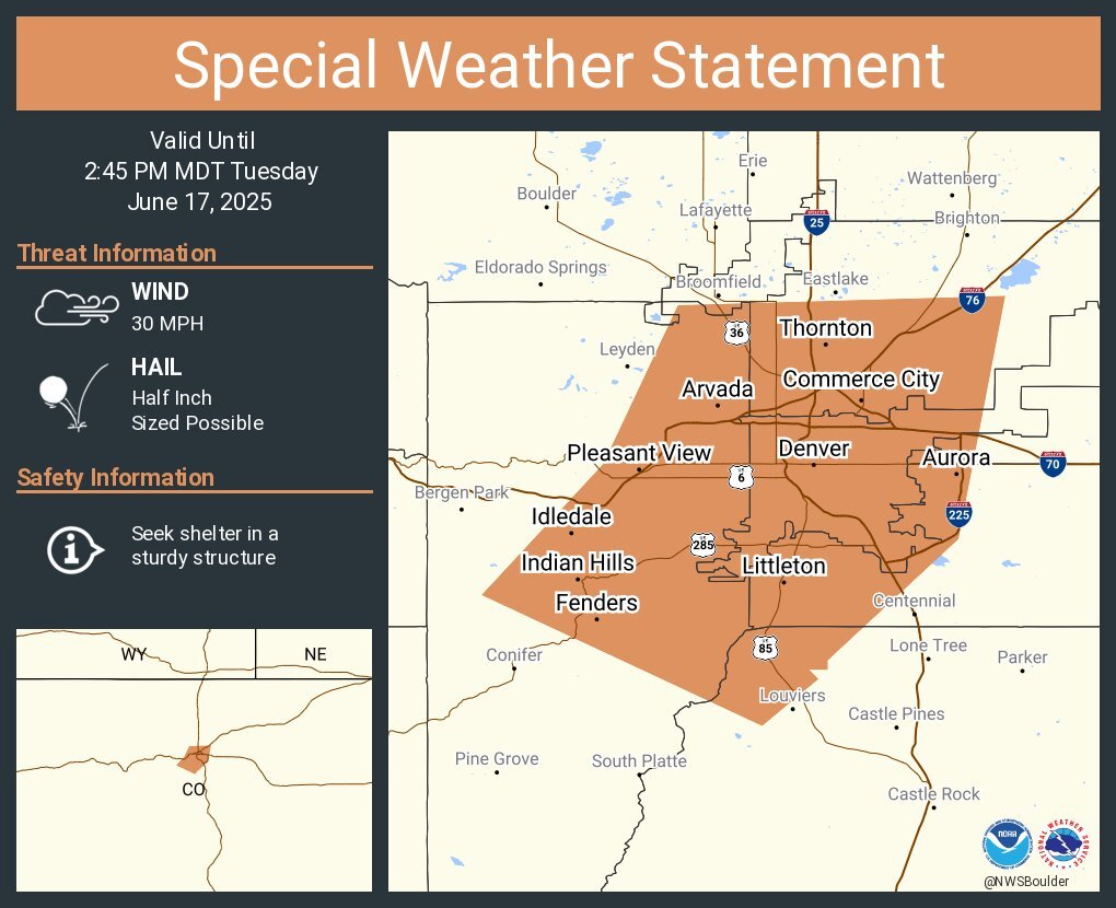
2:00 p.m. | Strong storms entering Denver metro | The NWS said a line of strong thunderstorms extending 10 miles NW of Denver to 14 miles SW of the metro is moving east at 30 mph and could drop half inch-sized hail.
Some communities impacted: Denver, portions of Aurora, Lakewood, Arvada, Westminster, among others. Here is the special weather statement from the NWS.
1:52 p.m. | Poudre Valley REA power outages | The electric co-op said around 750 customers are without power near Thompson River Range, The Ridge and Johnstown Corner "as weather continues in the area."
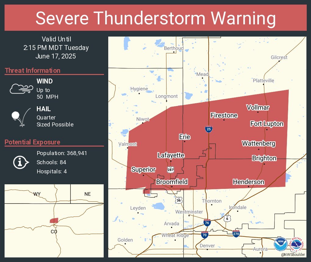
1:48 p.m. | Severe thunderstorm near Lafayette | The NWS issued a severe thunderstorm warning for a cell capable of producing quarter-sized hail near Lafayette — 22 miles north of Denver. Broomfield and Brighton could also see impacts.
The storm is moving east at 35 mph. NW Adams, NE/SE Boulder, Broomfield and SW Weld Counties are in the warning until 2:15 p.m.
1:45 p.m. | Weld County severe thunderstorm | The NWS in Boulder has issued a severe thunderstorm warning for West Central Weld County until 2:15 p.m. for a storm capable of dropping quarter-sized hail. The storm is over Windsor — 7 miles southeast of Fort Collins — moving east at 10 mph, said the NWS.
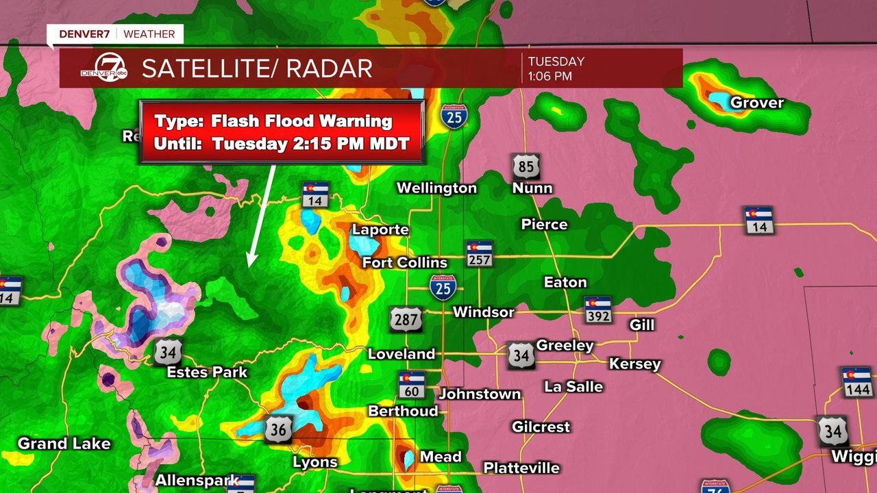
1:35 p.m. | Weather update| Denver7 chief meteorologist Lisa Hidalgo said another round of severe storms is headed toward areas hit hard overnight. "You'll see more rain and potentially even more hail near Milliken, Johnstown, Fort Collins and Wellington within the next hour," said Hidalgo.
Check Denver7 weather radar at this link
1:33 p.m. | Severe thunderstorm warning | Quarter-sized hail is possible in a severe storm 10 miles south of Hugo — 24 miles southeast of Limon — moving SE at 15 mph, said the NWS.
The severe thunderstorm warning for East Central Lincoln County is in effect until 2:15 p.m.
1:30 p.m. | Tornado warning expires | The tornado warning for NW Teller, West Central El Paso Counties expired at 1:30 p.m.
12:52 p.m. | Severe thunderstorm warning Larimer County | A severe storm located near Livermore — 21 miles northwest of Fort Collins — is capable of 60 mph wind gusts and quarter-sized hail. The warning is in effect until 1:30 p.m.
12:47 p.m. | Tornado warning NW Teller, West Central El Paso | The NWS in Pueblo issued a tornado warning for a storm showing radar-indicated rotation near Woodland Park — or 19 miles northwest of Colorado Springs. The storm is moving east at 15 mph, said the NWS.
The tornado warning is in effect until 1:15 p.m.

12:42 p.m. | Severe thunderstorm warning East Central Lincoln County | Golf ball-sized hail is possible in a severe storm located 17 miles southeast of Limon. "The largest hail is expected to fall just east of Hugo," wrote NWS forecasters.
The warning is in effect until 1:30 p.m.

12:35 p.m. | Severe thunderstorm warning Larimer County | Quarter sized-hail is possible in Southeastern Larimer County where a severe storm was located 15 miles west of Fort Collins — moving east at 20 mph, according to the NWS. The warning is in effect until 12:45 p.m.
12:19 p.m. | Severe thunderstorm warning Lincoln County | Golf ball-sized hail is possible in a severe-warned thunderstorm for East Central Lincoln County for a storm 11 miles east of Limon, moving southeast at 10mph, said the NWS. 60 mph wind gusts are possible.

12:13 p.m. | Severe thunderstorm warning | Northeastern Lincoln County remains under a severe thunderstorm warning until 12:45 p.m. The NWS said a storm 7 miles east of Limon — moving southeast at 10 mph — could drop half dollar-sized hail with 60 mph wind gusts.
10:32 a.m. | Severe thunderstorm watch | A severe thunderstorm watch is in effect for the Denver metro until 5 p.m. where the I-25 corridor could see storms dropping large hail with wind gusts up to 80mph Tuesday afternoon.

Denver7 | Weather
Storms move out tonight; warmer, drier weather returns to Denver Wednesday
9:00 a.m. | Denver International Airport delays | There are 509 flight delays in and out of DIA Tuesday morning, according to FlightAware.
8:00 a.m. | Denver International Airport ground stop | The Federal Aviation Administration has issued a ground stop for DIA from 8-9 a.m. Tuesday due to low ceilings. Flights are delayed 39 minuets, on average, according to the FAA.
7:30 a.m. | Hail damage | Denver7's Allie Jennerjahn was on the ground in the northern Colorado town of Milliken surveying damage left behind by massive hail stones that fell during an early-morning storm
7:12 a.m. | Denver International Airport delays | There are 406 flight delays in and out of Denver International Airport Tuesday morning, according to the flight tracking website FlightAware. 324 of those are Southwest Airlines flights. There are no cancellations.
5:57 a.m. | Severe thunderstorm warning | Arapahoe, Douglas and Elbert counties are under a severe thunderstorm warning until 6:30 a.m.
Severe Thunderstorm Warning including Arapahoe County, CO, Douglas County, CO, Elbert County, CO until 6:30 AM MDT pic.twitter.com/Dz3GN5b4ZY
— NWS Boulder (@NWSBoulder) June 17, 2025
5:54 a.m. | Severe thunderstorm warning | A severe thunderstorm warning has been issued for Otis and Platner, Colorado, until 6:30 a.m.
5:32 a.m. | Severe thunderstorm warning | Strasburg, Byers and Deer Trail, Colorado, are under a thunderstorm warning until 6:15 a.m.
5:22 a.m. | Severe thunderstorm warning | A severe thunderstorm warning has been issued for Foxfield, Colorado, until 6 a.m.
5:20 a.m. | Severe thunderstorm warning | A severe thunderstorm warning has been issued for Akron, Colorado, until 6 a.m.
4:52 a.m. | Severe thunderstorm warning | A severe thunderstorm warning has been issued for Bennett, Colorado, until 5:30 a.m.
4:50 a.m. | Severe thunderstorm warning | A severe thunderstorm warning has been issued for Brush, Colorado until 5 a.m. The storm will contain golf-ball sized hail, the NWS Boulder said.
4:41 a.m. | Severe thunderstorm warning | A severe thunderstorm warning has been issued for Denver International Airport and Brighton, Colorado, until 5:15 a.m.
- Denver7 viewer Michael sent Luber a video of the weather impacting DIA Tuesday morning, in the video player below:
4:37 a.m. | Hail in Henderson | Denver7 viewer Jessica sent this picture of hail in her Henderson, Colorado neighborhood Tuesday morning.

4:30 a.m. | Denver7 Chief Meteorlogist Lisa Hidalgo's forecast | Strong storms hit northeastern Colorado overnight and those cells are pushing south and east across the plains Tuesday morning. The biggest threat with these cells is large hail, pockets of heavy rain and lightning.

Today's Forecast
Severe storms hits northeastern Colorado overnight
These storms will fizzle out, but we'll see another round of storms Tuesday afternoon and early evening. We could see hail up to 2 inches in diameter, wind gusts near 80mph and more lightning. Some of the strongest storms will likely be across the far eastern plains, but the risk of severe weather does include the Denver metro area.
Click here to see Denver7 Chief Meteorologist Lisa Hidalgo's full forecast.
4:19 a.m. | Severe thunderstorm warning | A severe thunderstorm warning has been issued for Eastlake, Colorado, until 4:45 a.m. The NWS Boulder warn of 2-inch sized hail with this storm.
4:15 a.m. | Severe thunderstorm warning | A severe thunderstorm warning has been issued for Hillrose and Snyder, Colorado, until 5 a.m. This storm will contain golf-ball sized hail, according to the NWS Boulder.
4:07 a.m. | Severe thunderstorm warning | A severe thunderstorm warning has been issued for Broomfield, Northglenn and Lafayette, Colorado, until 4:45 a.m., the NWS Boulder said.

Some minor street flooding was visible as a big cell passed over Boulder County, Luber said.
3:55 a.m. | Severe thunderstorm warning | A severe thunderstorm warning has been issued for Hudson, Keensburg and Prospect Valley, Colorado, until 4:30 a.m. The destructive storm will contain baseball-sized hail, according to the NWS Boulder.
3:50 a.m. | Major storm cell passing through Fort Morgan | Heavy rain, hail, strong winds and street flooding were visible in Fort Morgan Tuesday morning as a major storm cell passed through the area, Denver7 Traffic Expert Jayson Luber observed.
There is a major cell right now passing through Ft Morgan. Heavy rain, hail, strong winds, street flooding. Be careful out there right now! pic.twitter.com/Y6JAj2SPi0
— Jayson Luber (@Denver7Traffic) June 17, 2025
3:49 a.m. | Severe thunderstorm warning | A severe thunderstorm warning has been issued for Fort Morgan, Wiggins and Log Lane Village, Colorado, until 4:30 a.m. The NWS Boulder said these areas will also see baseball-sized hail.
3:33 a.m. | Severe thunderstorm warning | A severe thunderstorm warning has been issued for Greeley, Evans and Johnstown Colorado, until 4 a.m. These areas will see baseball-sized hail, according to the NWS Boulder.
Severe Thunderstorm Warning including Greeley CO, Evans CO and Johnstown CO until 4:00 AM MDT. This destructive storm will contain baseball sized hail! pic.twitter.com/bV2sNv2i6N
— NWS Boulder (@NWSBoulder) June 17, 2025
3:30 a.m. | Severe thunderstorm warning | The severe thunderstorm warning for Eaton, Severance and Ault, Colorado, was extended until 4 a.m. These areas will also see 2-inch sized hail, the NWS Boulder said.
3:23 a.m. | Severe thunderstorm warning | A severe thunderstorm warning has been issued for Wiggins, Weldona and Raymer, Colorado, until 4 a.m.
3:18 a.m. | Severe thunderstorm warning | A severe thunderstorm warning has been issued for Windsor, Johnstown and Milliken, Colorado, until 4 a.m. These areas will see 2-inch sized hail, according to the NWS Boulder.

Alli Fitzgibbons in Milliken sent in this picture to Denver7 Tuesday morning of the storm aftermath in her neighborhood.
If you have pictures or videos to share of the storm or the aftermath please do. This is from Alli Fitzgibbons in Milliken. pic.twitter.com/WMynOTJ5mA
— Jayson Luber (@Denver7Traffic) June 17, 2025
3:14 a.m. | Severe thunderstorm warning | The severe thunderstorm warning for Larimer and Weld counties was extended until 3:45 a.m.
3:08 a.m. | Severe thunderstorm warning | A severe thunderstorm warning has been issued for Pierce and Nunn, Colorado, until 3:30 a.m.
2:44 a.m. | Severe thunderstorm warning | A severe thunderstorm warning has been issued for Larimer and Weld counties until 3:15 a.m.
Severe Thunderstorm Warning including Larimer County, CO, Weld County, CO until 3:15 AM MDT pic.twitter.com/E6omOSWaxV
— NWS Boulder (@NWSBoulder) June 17, 2025
2:23 a.m. | Severe thunderstorm warning | A severe thunderstorm warning has been issued for Garden City, Cornish and Galeton, Colorado, until 3:15 a.m. This storm will bring golf-ball sized hail, the NWS Boulder said.
2:20 a.m. | Sever thunderstorm warning | A severe thunderstorm warning has been issued for Eaton, Ault and Galeton, Colorado, until 2:45 a.m.
2:17 a.m. | Severe thunderstorm warning | A severe thunderstorm warning has been issued for Wellington, Colorado, until 2:45 a.m. There was hail 1.5 inches in diameter reported from this storm on the east side of Wellington, according to the NWS Boulder.
1:58 a.m. | Special weather statement | The National Weather Service in Boulder issued a special weather statement for Eaton, Severance and Ault, Colorado, until 2:30 a.m.
A special weather statement has been issued for Eaton CO, Severance CO and Ault CO until 2:30 AM MDT #COwx pic.twitter.com/HRHNYHdVwW
— NWS Boulder (@NWSBoulder) June 17, 2025
Click here to watch the Denver7 live weather stream.