


DENVER — Warm temperatures and active skies will set the stage for showers and thunderstorms later today, with the Eastern Plains at risk for large hail, damaging winds and even an isolated tornado.
The I-25 Corridor and foothills may see less-intense storms, but afternoon and evening hours could bring significantly stronger weather to areas farther east, depending on how far humid air pushes westward.
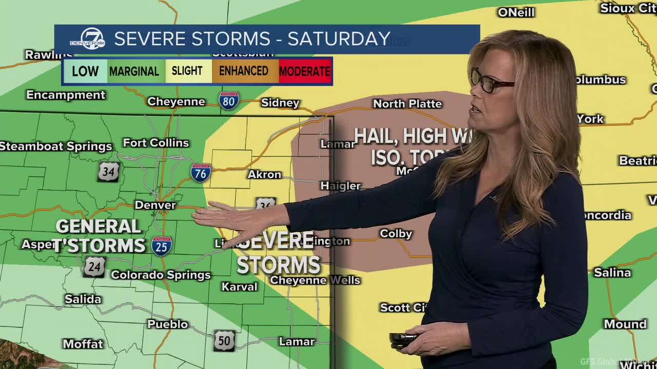
The Denver7 meteorologist Stacey Donaldson said a weather disturbance moving overhead will help storms develop, while a boundary near our area separates humid air to the east from much drier air to the west. Where that boundary settles will play a big role in storm intensity — if the moist air moves farther toward I-25, the threat of severe weather expands. In the most humid zones, a few storms may produce large hail, damaging gusts up to 70 mph, and a small chance for an isolated tornado.
Other locations will still see showers and storms later today, but with lower severe impacts. The unsettled pattern continues into Sunday as another weather system approaches. Showers and thunderstorms are expected again during the afternoon and evening, along with breezy north winds. Small shifts in moisture and front placement will be key to Sunday’s storm strength — even with modest instability, strong winds higher in the atmosphere could support a few strong to severe storms.
The Denver7 News team is tracking the latest severe weather alerts and storm reports below.
LINKS: Latest forecast | Radars | Traffic | Weather Page | 24/7 Weather Stream
Saturday, May 16
5:02 p.m. | Severe storm near Proctor | Warning in effect until 6:00 p.m., said NWS in Boulder.

4:28 p.m. | Philips County severe storm | Warning in effect until 5:15 p.m., said NWS in Boulder.

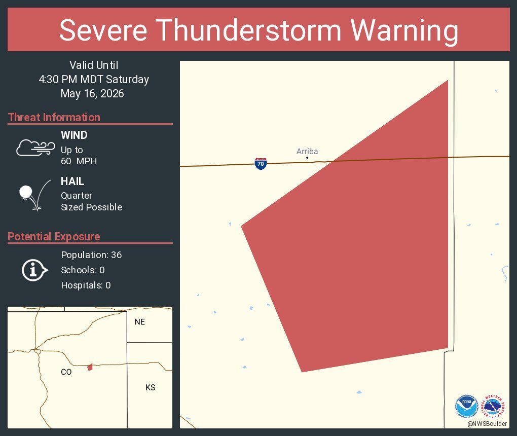
4:02 p.m. | Lincoln County severe storm | Quarter sized-hail also possible in Lincoln County. Severe t-storm warning issued until 4:30 p.m.
3:59 p.m. | New severe t-storm warning | Quarter sized-hail possible in storm near Akron. Severe t-storm warning issued until 4:45 p.m.

3:30p.m. | CSU ceremonies impacted | CSU Police & Safety on social media said CHHS ceremonies would be delayed Saturday:
"Colorado State University is anticipating weather this afternoon around 3:30-4 p.m. The CHHS recognition ceremonies at Moby Arena will experience a delay and will now start at 5:30 p.m. and 8 p.m."
3:27p.m. | Grass fire reported | The NWS in Boulder also said a grass fire was reported north of Colorado Air and Space Port. Here's their social post below:
"Heads up if you're near Bennett: Ongoing grass fire to the north of the Colorado Air and Space Port. Winds are currently out of the N and NE," posted the NWS.

3:24p.m. | Severe t-storm warning | A storm near Hugo could produce half dollar-sized hail and 60 mph winds.

3:05 p.m. | Severe t-storm watch issued | Several Northeastern Colorado counties are under a severe thunderstorm watch until 10 p.m., according to NWS in Boulder.

Colorado counties:
- Cheyenne
- Elbert
- Kit Carson
- Lincoln
- Logan
- Morgan
- Phillips
- Sedgwick
- Washington
- Yuma
Kansas counties:
- Cheyenne
- Decatur
- Gove
- Graham
- Logan
- Norton
- Rawlins
- Sheridan
- Sherman
- Thomas
- Wallace
2:20 p.m. | Severe t-storm warning | NWS in Boulder is tracking a severe thunderstorm SW of Limon with quarter size hail possible

2:14 p.m. | Matheson storm |From NWS Boulder:

2:00 p.m. | Severe thunderstorm 'likely' |From NWS Storm Prediction Center:

1:45 p.m. | Tracking early stormss |From NWS in Boulder:
"A special weather statement has been issued for Simla CO and Matheson CO until 2:15 PM MDT"

12:45 p.m. | Stacey's Forecast | A weather disturbance moving overhead will help storms develop, while a boundary near the area separates humid air to the east from much drier air to the west.

Where that boundary ends up this afternoon will make a big difference in how intense the storms become. Areas farther east could see much stronger storms if the more humid air pushes westward. In that case, a few storms may produce large hail, damaging wind gusts around 70 mph, and even a small chance for an isolated tornado.
▶️ Click here to watch the Denver7 live weather stream or watch below.