


UPDATE (12:38 p.m., Thursday, Dec. 9): We have a new story up with the latest snow forecast for the mountains and the plains as of Thursday afternoon. Click here to read the latest on what to expect.
———
DENVER – Winter storm warnings and winter weather advisories were issued Wednesday for most of Colorado’s mountains through Friday, where some areas could see upwards of 2 feet of snow.
Most of the advisories go into effect Wednesday evening for the mountains and will stay in effect until 5 p.m. Friday, according to the National Weather Service.
The areas under winter storm warnings include Rabbit Ears Pass, which could see 15-30 inches of snow, the areas around Rocky Mountain National Park and Cameron Pass above 9,000 feet, which could see 10-20 inches, the higher elevations of the San Juan and Sawatch Mountains, which could also see 10-20 inches, and the areas surrounding Crested Butte, where 1-2 feet of snow is possible.
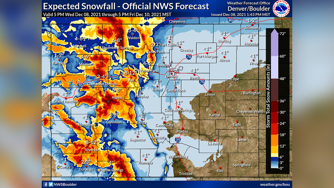
Winter weather advisories are in effect for the areas including the Indian Peaks Wilderness, Summit County, eastern Lake County, western Chaffee County and the La Garita Mountains, where roughly 4 to 12 inches of snow are forecast depending on the location and elevation.
Along the western I-70 mountain corridor, winter storm watches are in effect, with 3-6 inches forecast at the lower elevations Thursday evening into Friday.
On Wednesday, most of the heaviest snow is expected to fall over the Gore Range before moving over the rest of the northern mountains early Thursday.
The National Weather Service in Grand Junction said some areas could see snowfall rates of up to 2 inches an hour, which will likely bring 10 to 20 inches of snow across the northern mountains and 8 to 16 inches across most of the rest of the mountains.
“These may be conservative estimates, so stay tuned,” forecasters wrote Wednesday morning.
The Colorado Avalanche Information Center issued avalanche watches for the Steamboat/Flat Tops, Aspen, Gunnison, North San Juan and South San Juan zones on Wednesday and said “very dangerous” avalanche conditions will develop by Thursday evening – especially on northerly-facing slopes.
“Travel in avalanche terrain is not recommended from late Thursday through Friday,” the CAIC said.
For Denver and the plains, snowfall estimates have gone down slightly over the past 24 hours.

“Not as bullish for snow chances and amounts on the plains as previous, although we’re still forecasting accumulating snow for the I-25 corridor including that all important snow board out at DIA,” forecasters from the NWS Boulder office wrote Wednesday morning, referring to the official measurement site at Denver International Airport.
The NWS said it was still forecasting about an inch of snow at the airport and generally around 0 to 2 inches along the Front Range plains, but also added there was "no guarantee" Denver's snowless streak is broken.
🏔️Mountains: First significant winter storm of the season moves in tonight. Travel conditions worsen Thursday - Thu night as heavier snow develops.
— NWS Boulder (@NWSBoulder) December 8, 2021
🌆I-25 Corridor & Plains: Just areas of light snow Thu Night - Friday am. No guarantee we break Denver's snowless streak. #COwx pic.twitter.com/wxDy0DCXBG
Wednesday marks the 231st consecutive day without snow in Denver, good for second on the all-time record books. The longest snow-free streak in Denver came in 1887, when the city went 235 consecutive days without snow. This year has already by far set the record for the latest first snowfall in Denver, and November was one of the warmest and driest on record for the city.
Statewide snowpack sat at 49% of median since 1991 on Wednesday ahead of the incoming storm. But all basins were below 70% of median across the state, and the San Miguel, Dolores, Animas and San Juan, upper Rio Grande, and Arkansas basins were all between 30% and 50% of median.

Click here to watch the Denver7 live weather stream.


