DENVER – The National Weather Service in Boulder upgraded the full Denver metro area to winter storm warnings on Wednesday afternoon for the incoming snowstorm, as models are indicating heavier snowfall overnight into Thursday morning.
In the immediate metro area east toward Byers, the NWS is forecasting 4-8 inches of snow through about noon Thursday. In the Front Range foothills and Palmer Divide, people should expect 5-10 inches of snow, with up to 15 inches in the higher elevations of the foothills.
MORE: Closings and Delays | Full forecast | Radars | Traffic | Weather Page | 24/7 Weather Stream | 24/7 Radar Stream
For the mountains and plains east of Castle Rock and Colorado Springs, winter weather advisories are in effect into Thursday. The mountains could get 4-10 inches of snow, while the eastern plains should see 2-5 inches, according to the National Weather Service.
Denver & Byers now included in a Winter Storm Warning starting 6 PM Wed to Thurs 12 PM. Snow covered roads will make travel hazardous, especially late tonight and Thursday morning. For more info: https://t.co/6Jl2c58pfd #COwx pic.twitter.com/AKr7w9sDwA
— NWS Boulder (@NWSBoulder) March 16, 2022
The uncertainty in the forecast that persisted Wednesday morning has shored up slightly surrounding exactly when rain might switch over to snow at elevations below 7,000 feet.
As of 3:20 p.m., temperatures above 7,000 feet were already below freezing, but temperatures on the plains were in the upper 40s. Because of that, the NWS said it believes the switchover from rain to snow in most of the metro area and Palmer Divide would happen between 8 p.m. and midnight.
But there is still some uncertainty as of Wednesday afternoon as to where exactly the center of the storm might set up and how much upslope conditions could push up snowfall rates and overall totals, the NWS said.
Sometime around 3 or 4 a.m., a northeasterly upslope flow is expected to kick in and bring widespread moderate-to-heavy snow, with rates up to 1 inch per hour, according to the NWS.
“Though confidence in forecast snow totals remains unusually low, the potential for a heavily impacted Thursday morning commute continues to grow at this time,” forecaster wrote Wednesday afternoon. “Be prepared for slick conditions, particularly during the first half of the rush.”
Temperatures will return to about normal on Friday before temperatures move into the 60s in Denver by Sunday, with another storm likely for Monday into Tuesday.
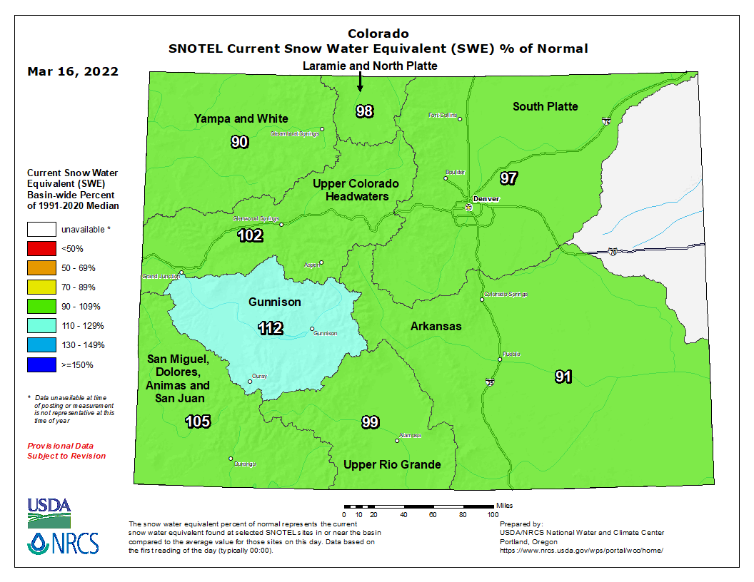
Statewide snowpack was 98% of median as of Wednesday morning, and all eight of the statewide river basins were above 90% of median levels to start the day.

The Gunnison (112%), San Miguel, Dolores, Animas and San Juan (105%) and Upper Colorado Headwaters (102%) basins were all above median levels. The Upper Rio Grande (99%), Laramie and North Platte (98%), South Platte (97%), Arkansas (91%), and Yampa and White (90%) basins were all slightly below median levels to start the day.
You can always watch 24/7 weather, radar and news updates on the free Denver7+ app on your TV.


