


DENVER — Colorado’s mountains look poised to get their first major snowfall of the season Sunday after a windy Saturday, but Denver is unlikely to see measurable snow in the storm.
Fire danger is high as winds pick up through the day. A Red Flag Warning is in effect for the foothills, Palmer Divide and over the eastern plains until 7 p.m. Sunday. A trough moving into Colorado Saturday night will shift conditions statewide and bring snow to the mountains for most of the day Sunday, according to forecasts.
The snow level will start out around 9,000 feet Sunday and will continue to drop through the day, according to the NWS. The trough is then expected to split as it moves across the state – the first part on Sunday night and the second part further toward the southeast into New Mexico, which will put most of the precipitation outside of the Denver metro area.
The mountains are forecast to receive 4-10 inches of snow, with temperatures dropping from the upper 30s to the mid-20s through the day before the snow clears out Monday morning. That will be a boost to Colorado’s ski areas that recently started making snow and to Arapahoe Basin, which is set to open Sunday.
Check here for the latest watches and warnings in effect for Colorado.
Denver and the plains are likely to only see rain Sunday night into Monday morning, though there is a chance some of the precipitation falls as snow, according to the NWS.
“There could be a couple of precipitation bands that produce rain and snow showers across the plains that may result in the first measurable snowfall for a few areas,” the NWS wrote in its forecast discussion. “Any snow that sticks will stay below an inch and most areas will only see a trace.”
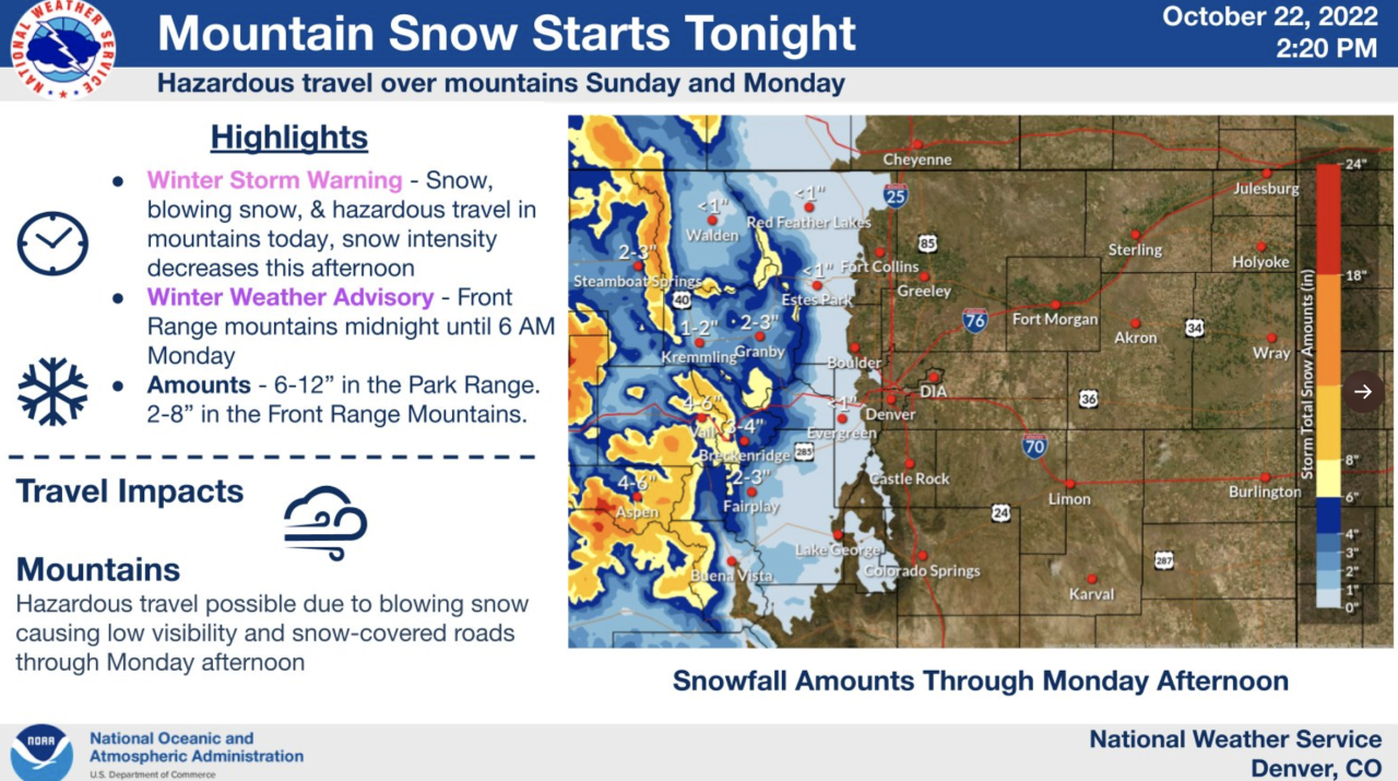
But accompanying the system are strong winds Sunday in both the mountains and plains, which could gust up to 50 mph on the plains. As such, blowing dust and fire weather will also be a concern Sunday on the plains.
Denver did not receive its first measurable snowfall of the season until Dec. 10 last year — smashing the all-time record. It saw its first freeze on Oct. 13. The city has not seen its first freeze this late since 2015, when the first freeze came on Oct. 28.
Temperatures Monday morning in Denver are likely to be close to freezing, but highs should reach near 50 degrees. The next system forecasters are watching would move in on Thursday, with the potential for rain and snow at the lower elevations and snow in the mountains if current forecasts hold.
Stay updated on the latest forecast by heading over to our weather section or by watching our 24/7 weather stream on Denver7+.