


UPDATE (Friday, 2:20 p.m.): The National Weather Service in Boulder has issued winter weather advisories for the northern and central mountains, Larimer, Weld, Morgan, Logan, Sedgwick and Phillips counties. We have a newly updated story with what to expect through the weekend. Click here for the latest.
———
DENVER – While high temperatures in Denver could reach the 70s Thursday, they won’t stick around long, as rain is expected to move into the area Friday night and change over to snow this weekend as temperatures continue to fall.
Temperatures are expected to reach the mid-60s in Denver on Friday before temperatures begin to drop Friday evening and precipitation moves into northeastern Colorado.
The initial moisture will likely start as rain, and some thunderstorms could develop with heavy rain and small hail overnight, according to the National Weather Service in Boulder. But it will change over to a wintry mix and then to snow over the plains as we move into early Saturday morning.
A series of storm systems will bring colder temps & snow beginning Friday night & continuing through the weekend. Precipitation begins as rain Friday & early Saturday for lower elevations. Roads are expected to become slick at times, especially in the mountains. #cowx pic.twitter.com/fRJlcOuWDs
— NWS Boulder (@NWSBoulder) March 3, 2022
On Saturday morning, another cold front will move across northeastern Colorado and increase the chance for a brief period of snow showers. However, precipitation is expected to decrease Saturday afternoon, though the chance is higher for the mountains at that time, according to the NWS.
A trough will move over the area Saturday night into Sunday morning, lowering temperatures further and bringing another round of widespread and steady snow compared to the first front. The snow showers are likely to stick around on and off through Monday as of Thursday’s forecast release.
But exactly where the heaviest snow falls during the multi-day storms remains somewhat in question, according to the NWS.
“There remains a considerable amount of uncertainty with regards to snowfall totals for this period of active weather,” NWS forecasters wrote on Thursday.
The NWS said the northern mountains will likely see the most snow in the storm and that an advisory for those areas would likely be issued first. And there could be heavy banded snow on the far northeastern plains Friday night, according to the NWS.
After Friday, it is likely advisories, watches or warnings will be issued for most of northeastern Colorado for Sunday into Monday, the NWS said.
After a quick boost from last week’s storms, the statewide snowpack leveled off during the dry period over the past week or so. It sat at 92% of median as of Thursday.
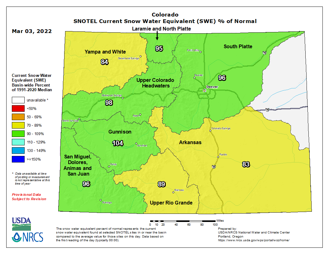
The Gunnison basin was the only of the eight rivers basins above median levels Thursday, at 105% of median, but the others are not too far behind.
The Upper Colorado Headwaters (98%), South Platte (97%), Laramie and North Platte (95%), San Miguel, Dolores, Animas and San Juan (97%), and Upper Rio Grande (90%) basins were all slightly below median levels as of Thursday.
The Yampa and White (85%) and Arkansas (84%) basins were slightly further below median levels.
Drought across Colorado has remained mostly unchanged over the past three months, according to the latest Thursday release from the U.S. Drought Monitor.

Nearly 92% of the state is seeing moderate or worse drought, and 57% of the state is experiencing severe drought or worse. Eight percent of the state – along the southern border and in northwestern Moffat County – is experiencing extreme drought conditions.
Denver7 will continue to provide updates as we track this storm into and through the weekend. You can always watch 24/7 weather, radar and news updates on the free Denver7+ app on your TV.


