
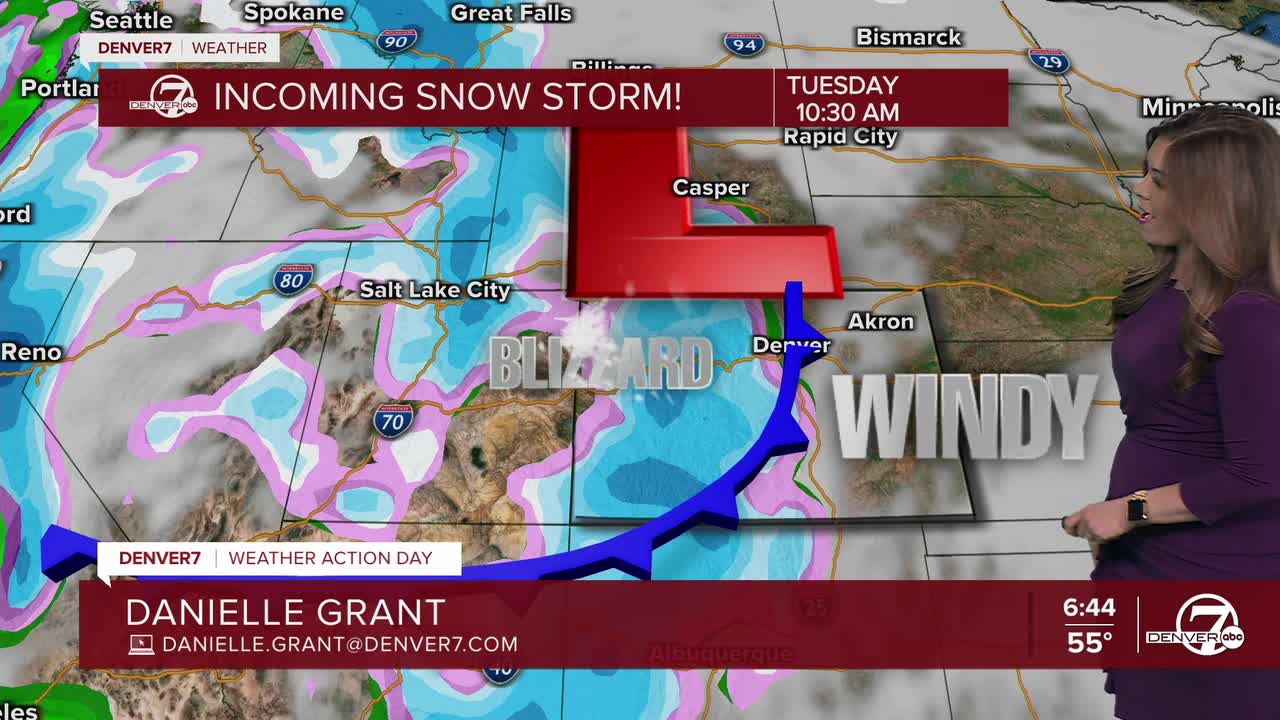


Colorado will have two main story lines for weather this week: Snowstorms will settle over the mountains while the extremely dry Front Range prepares for conditions prime for quick fire spread.
Monday marks the last above-average-temperature day in most mountain communities before a stretch of active wintry weather, according to the National Weather Service (NWS) out of Boulder. Temperatures will dip along the Front Range too — especially after a weekend where Denver almost reached 70 degrees — but highs will remain in the 40s and 50s in most places, with slightly cooler temperatures farther east on the plains.
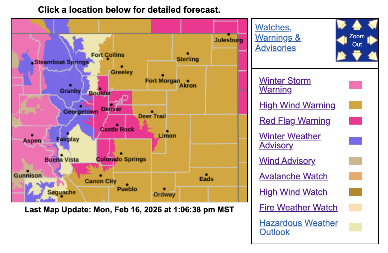
This combination of wintry weather, avalanche risk, strong winds and dry conditions has made for a colorful NWS map, as seen below.
Temperatures are expected to jump back to above-normal numbers by late this weekend and early next week.
Let's start with the much-needed snow in the mountains.
Snow will return to the mountains early Tuesday and is expected to last through at least Thursday.
The heaviest snow is forecasted for Tuesday morning and Wednesday, with snow squalls possible. Tuesday morning will be the toughest time along the Interstate 70 corridor, said Paul Schlatter with NWS Boulder.
The good news: "We expect that the initial wave of snow Tuesday morning into early Tuesday afternoon will be pretty impressive," NWS wrote in its forecast discussion.
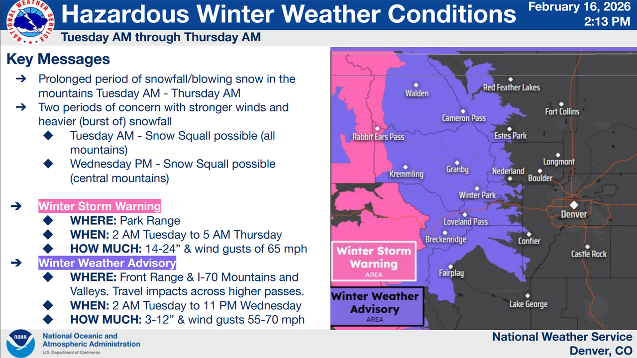
A winter storm warning and winter weather advisory will both go into effect at 2 a.m. on Tuesday.
Here's the areas that are affected by both:
Under the winter storm warning:
- West Jackson and west Grand counties above 9,000 feet, including Rabbit Ears Pass (12-24 inches of snow expected; wind gusts as strong as 65 mph)
- Elkhead and Park Mountains (10-20 inches of snow expected; wind gusts as strong as 60 mph)
- Grand and Battlement Mesas, west Elk and Sawatch Mountains, including Crested Butte, Marble, Monarch Pass and McClure Pass (10-20 inches of snow expected; wind gusts as strong as 70 mph)
- Gore and Elk Mountains and Central Mountain Valleys, including the Flat Tops, Aspen, Snowmass, Vail Pass and Minturn (8-16 inches of snow expected; wind gusts as strong as 65 mph)
- Northwest and southwest San Juan Mountains including Telluride, Ouray and Silverton (10-20 inches of snow expected; wind gusts as strong as 70 mph)
- Eastern Sawatch Mountains and eastern San Juan Mountains, both above 11,000 feet (8-24 inches of snow expected; wind gusts as strong as 70 mph)
Under the winter weather advisory:
- Jackson, Grand and Summit counties below 9,000 feet, including North Park, Grand Lake, Fraser, Kremmling, Dillon and Granby (5-10 inches of snow expected; wind gusts as strong as 55 mph)
- Rocky Mountain National Park, Medicine Bow Range, mountains of Summit County, Mosquito Range and Indian Peaks (5-12 inches of snow expected; wind gusts as strong as 70 mph)
- Upper Yampa River Basin, including Steamboat Springs (4-8 inches of snow expected; wind gusts as strong as 45 mph)
- Upper elevations in the La Garita Mountains, Lake County, western Chaffee County, western Mosquito Range, Rio Grande Valley and eastern San Juan Mountains (4-12 inches of snow expected; wind gusts as strong as 75 mph)
- Sangre de Cristo Mountains (up to 6 inches of snow expected; wind gusts as strong as 85 mph)
This storm will bring strong winds as well, with gusts maxing out at 60 to 70 mph. This will result in blowing snow, meaning some folks at higher elevations may see more trouble on the roads.
Sudden snow squalls are possible in all the above areas.
Denver7 Chief Meteorologist Lisa Hidalgo breaks down the heavy snow headed toward Colorado's ski resorts in the video below.
The on-and-off mountain snow throughout the week is expected to continue to impact travelers on the roads, so make sure to check conditions and closures before heading out the door. The NWS is warning that this storm could cause issues during the Tuesday morning and evening commute times.
Make sure you have an extra flashlight, food, water, and warm clothes in your car.
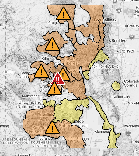
If you're headed out into the backcountry, make sure to check for avalanche danger first. Several avalanche watches are in effect for areas including the Elk Mountains, San Juan Mountains and the Park Range.
And let's now look at fire weather conditions on the Front Range and plains.
The Front Range and plains have at least a few more days of elevated and critical fire weather ahead before conditions ease up and the risk of danger decreases later in the week.
So far for Monday, the forecast looks "reasonably straightforward," the NWS reported, with winds increasing in the afternoon for the southern Interstate 25 corridor and eastern plains, where we will see elevated fire weather conditions and a few gusts between 30 and 40 mph. Relative humidity values may drop to as low as 10%.
- DENVER WEATHER LINKS: Hourly forecast | Radars | Traffic | Weather Page | 24/7 Weather Stream
The NWS reported that a "Denver cyclone" could develop during the day. That means that air that comes down off the Palmer Divide curls back toward the Denver area. This will keep Denver on the calmer and cooler side of things. Schlatter explained that the metro Denver area, Jefferson County and Boulder County will likely stay sheltered from the strongest of the wind gusts.
However, a red flag warning remains in place until 6 p.m. Monday for the highlighted areas in the map below.

The red flag warning covers Elbert County, Douglas County, Jefferson County, Gilpin County, Clear Creek County, Park County, Adams County, Arapahoe County, Pueblo County, Huerfano County, Teller County, Fremont County, Lincoln County, and Washington County, according to the NWS.
Denver7 Chief Meteorologist Danielle Grant explains the high fire danger for the Front Range and plains in the video below.
On Tuesday, the threat to dangerous fires rises from "elevated" status to "critical to extremely critical" fire weather conditions for the southern foothills and eastern plains, according to the NWS. Widespread gusts of 30 to 50 mph are expected, with some stronger gusts expected on the plains. Sustained winds could stay at 25 to 35 mph in places, according to the NWS' forecast.
On this day, the red flag warning will include the previously listed counties, in addition to Larimer County, Boulder County, Jefferson County, Broomfield County, Weld County, Morgan County, Logan County, Sedgwick County and Phillips County. That warning begins around 10 a.m. Tuesday and lasts through at least 7 p.m.
There is "broad support" for critical fire weather conditions for locations below 7,000 feet in elevation, the NWS said, adding that there is a good chance all of the current fire weather watches will be upgraded, but that has not yet happened as of noon Monday.
Here are the places under that fire weather watch as of publishing time:
- Pueblo County
- Huerfano County
- Crowley County
- Otero County
- Las Animas County
- Kiowa County
- Bent County
- Prowers County
- Baca County
Fire weather conditions will return Wednesday and Thursday south of Interstate 70, according to the NWS, which added that its scientists plan to provide a more detailed look at these days at a later time. Wednesday's main concern is Elbert and Lincoln counties, Schlatter said.
He added that NWS is no longer considering a PDS, or "Particularly Dangerous Situation," for this week.
Watch our weather stream in the video below.