


DENVER – Strong, hurricane-force winds will return to Colorado on Friday again fueling fire danger in what the National Weather Service (NWS) in Boulder described as a “particularly dangerous situation” for the Foothills and adjacent areas.
Sustained winds of 45 to 55 mph with gusts from 85 to 100 mph are likely Friday in Boulder and Jefferson Counties.
“The most extreme conditions are expected to be along Highway 93 from Jefferson County into Boulder County and along US-36 north of Boulder to the Larimer County line and westward. There will be a high potential for fast moving wildfires, should any new starts occur,” wrote NWS forecasters.

The NWS said residents in this area should be prepared in case a fire breaks out.
“This is a Particularly Dangerous Situation that poses a significant threat to life and property in the event of a wildfire start. Residents are urged to assemble an emergency supply kit and know their evacuation routes. In some cases, safe and timely evacuation may not be possible should a fire approach. Have multiple ways to receive instructions from emergency services, and evacuate if ordered to or if a fire threatens.”

Today's Forecast
80-100 mph winds return for Friday
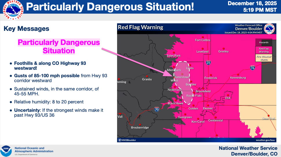
While the NWS is warning of a “particularly dangerous situation” for the foothills, high winds and low humidity will fuel critical fire weather conditions across northeastern Colorado including in the Denver metro and I-25 corridor.

A red flag warning goes into effect Friday at 10 a.m.
The western suburbs of Denver, Fort Collins, Longmont and Boulder go under the high wind warning at noon on Friday, said the NWS.
Denver7 will keep you updated with the latest alerts.

DENVER WEATHER LINKS: Hourly forecast | Radars | Traffic | Weather Page | 24/7 Weather Stream
Click here to watch the Denver7 live weather stream.