


UPDATE (Wednesday, Dec. 8, 3:06 p.m.): We have a new story Wednesday afternoon with the latest forecasts for the incoming snow storm. Click here for more.
———
DENVER – Colorado’s mountains are expected to finally see a decent couple of days of snowfall this week, and Denver could finally receive its first measurable snowfall late this week – both much needed to boost the state’s snowpack.
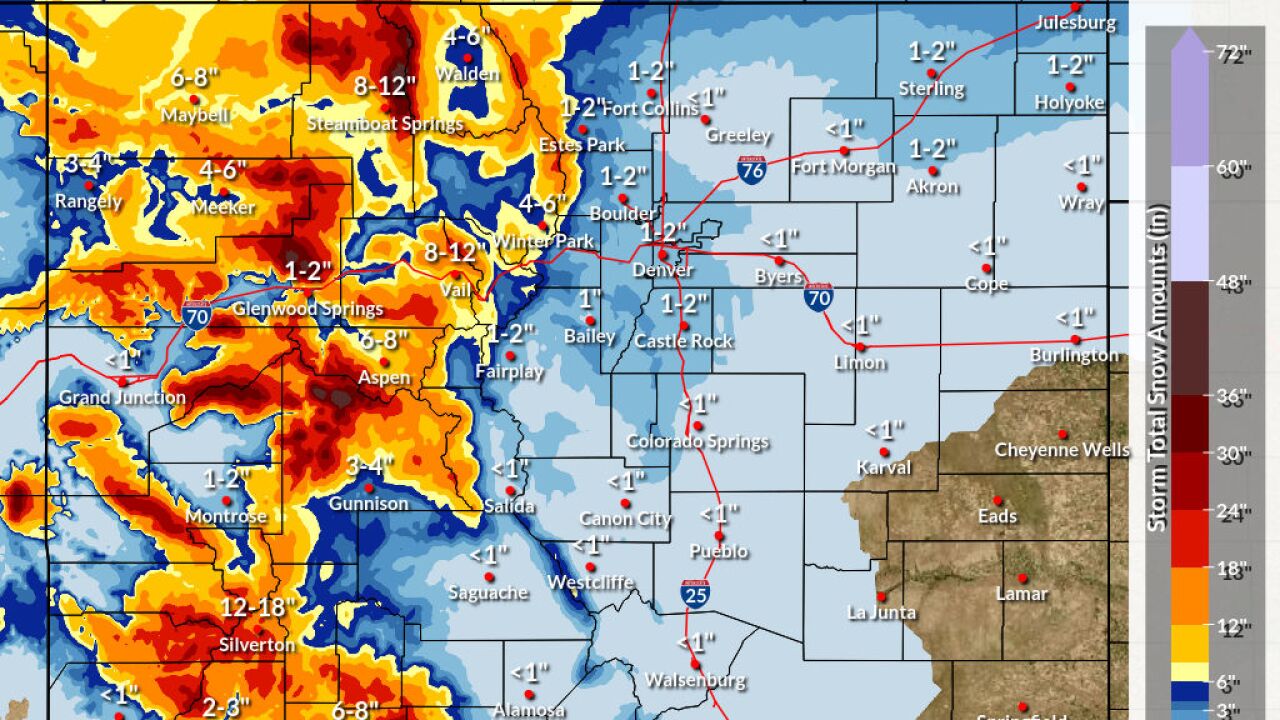
The National Weather Service in Boulder issued a winter storm watch Tuesday that will be in effect from Wednesday afternoon through Friday afternoon for the mountainous areas of Jackson, Grand, Larimer and Boulder counties above 9,000 feet.
The NWS says snow accumulations in those areas could reach 10 to 20 inches through Friday afternoon, with wind gusts of up to 50 miles per hour.
The winter storm watch will also be in effect for the western Mosquito Range, the eastern Sawatch Mountains, the La Garita Mountains and eastern San Juans above 10,000 feet, where 1 to 3 feet of snow are possible.
In the central and southwestern mountains, 1 to 2 feet of snow is possible in the storm, according to the NWS. And in the Upper Gunnison River Valley, 6 to 12 inches of snow is possible.
On Wednesday afternoon, some of the higher mountain passes could see 2 to 5 inches of snow, while the eastern Front Range slopes and foothills could see wind gusts of 50-65 miles per hour.
The mountains are expected to see more snow Thursday into Friday, and the NWS in Boulder says there is “some hope” that Denver’s snow-free streak could finally end. The NWS said in Tuesday’s forecast discussion that the mountains could see 5-12 inches over the 36-hour period into Friday.
Wednesday marks the 231st consecutive day without snow in Denver, good for second on the all-time record books. The longest snow-free streak in Denver came in 1887, when the city went 235 consecutive days without snow. This year has already by far set the record for the latest first snowfall in Denver, and November was one of the warmest and driest on record for the city.
Without measurable snow at the official observing station in Denver last night, we’re still moving up the ranks on the consecutive non-measurable snow days in Denver. We are now up to #5, and likely headed to #3 with no chance of snow til next Friday or Saturday. #COwx pic.twitter.com/RVBd00vIGT
— NWS Boulder (@NWSBoulder) November 25, 2021
The NWS said the lower elevations could see between a half-inch and 1 ½ inches of snow Thursday into Friday, with higher amounts toward the northern border.
The NWS said it is still possible for forecasts to change but that most models “appear to be in fairly decent agreement” in terms of the timing of the storm.
Southwestern Colorado got a shot of snow Tuesday morning. Seven inches of snow fell on Red Mountain Pass and the Camp Bird area got 6 inches of snow. Coal Bank Pass saw 4 inches while Molas Pass got 3 inches, according to NWS snowfall reports.
The snow had tapered off by noon, but another round of light snow is expected to move back into western Colorado Wednesday before another break. Then, on Thursday night, much of western Colorado could receive measurable snowfall – with significant snowfall in the mountains, particularly on southwest- and west-facing slopes, according to the NWS in Grand Junction.
Snowpack statewide was at 51% of its median dating back to 1991 on Tuesday. The northern four basins were all between 56% and 69% of their median snow-water equivalent, but the four southern basins were all below 50%.
The direst snowpack conditions Tuesday were in the San Miguel, Dolores, Animas and San Juan, and Upper Rio Grande, basins, which were at 27% and 29% of their median for this time of year, respectively.


