


DENVER – Weather forecasters are closely tracking Denver’s next snow chance, which arrives midweek, and could potentially bring slick conditions to the morning commute on Wednesday.
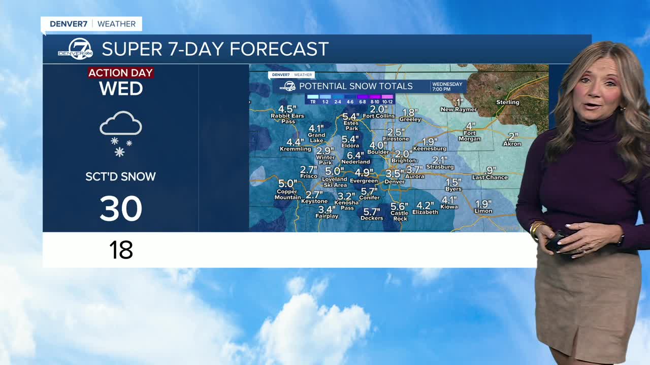
“Snowfall totals could be around 2 to 5 inches here along the Front Range and across the Denver metro area,” said Denver7 chief meteorologist Lisa Hidalgo. “Some of those heavier totals will likely be south along the Palmer Divide and also on the west side of town and up into the foothills.”
Here’s how the weather forecast is shaping up over the next several days in Denver.

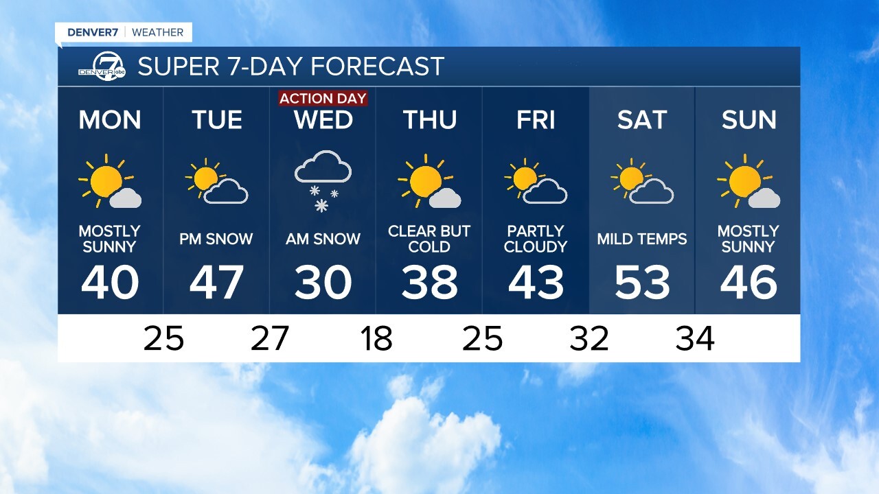
On Monday, skies in the metro clear out with a high temp of around 39 degrees expected before the overnight low drops into the upper 20s. For Tuesday, expect partly sunny skies in Denver with a high struggling to reach 40 degrees before snow starts overnight into Wednesday morning.
In the High Country, snow first starts to develop Tuesday morning.
“It looks like this next round will bring us inches of snow instead of the 0.2” we saw out at the airport this weekend, but it was officially our first snow of the season,” added Hidalgo.
The first snow of the season this weekend, while not much, officially ended Denver’s snowless streak and marked the 2nd latest first-snow ever in the city.
By the end of November, Denver's snow gauge should show around 12.4 inches of accumulations, so we are definitely behind were we normally are by this time of the season.

Forecasters with the National Weather Service (NWS) in Boulder warned of possible difficult travel conditions Wednesday morning.“There was a trend of slightly faster arrival, with snow developing across the I-25 Corridor and adjacent plains late Tuesday night. Thus, the Wednesday morning commute is shaping up to be slow and hazardous, with lingering impacts potentially lasting into the pm commute,” wrote the NWS.
As of Monday morning, no weather watches have been issued. Denver7 will update this story if weather alerts go into effect.
The NWS forecasts possible snow fall totals showing expected and high-end amounts. Here are those predictions, which could change as the storm system moves closer to Colorado.
Wednesday possible snow totals: Expected to high-end accumulation
- Allenspark: 3” to 10”
- Arvada: 2” to 6”
- Aurora: 2” to 6”
- Brighton: 1” to 5”
- Boulder: 2” to 5”
- Black Hawk: 2” to 6”
- Broomfield: 1” to 5”
- Castle Rock: 3” to 7”
- Centennial: 2” to 6”
- Commerce City: 1” to 5”
- Denver: 1” to 6”
- Denver International Airport: 1” to 6”
- Eldora: 4” to 9”
- Floyd Hill: 3” to 6”
- Fort Collins: 1” to 3”
- Fort Morgan: 1” to 6”
- Golden: 2” to 6”
- Highlands Ranch: 2” to 6”
- Idaho Springs: 2” to 6”
- Lakewood: 2” to 7”
- Littleton: 2” to 5”
- Longmont: 1” to 4”
- Loveland Pass: 5” to 7”
- Parker: 3” to 7”
- Superior: 2” to 5”
- Winter Park: 4” to 7”
The NWS forecasts a 72% chance of Denver seeing 2” or more of snow with Wednesday's storm.
After the midweek storm, temperatures slowly start to rebound with mild temperatures finally arriving for the weekend. Friday’s forecast for Denver shows partly cloudy skies and a high of 43 degrees before Saturday’s high warms into the low to mid 50s.
DENVER WEATHER LINKS: Hourly forecast | Radars | Traffic | Weather Page | 24/7 Weather Stream
Click here to watch the Denver7 live weather stream.