


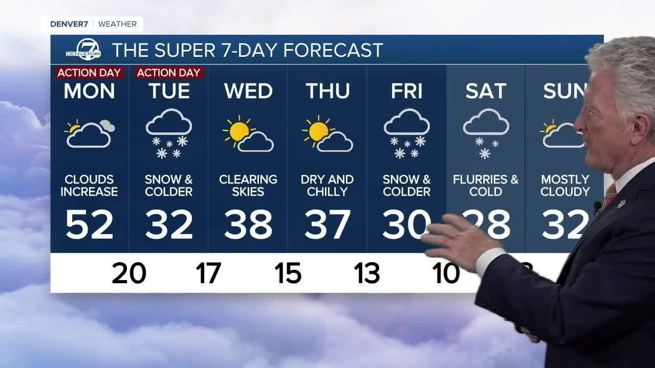
DENVER — A powerful storm is expected to roll into Colorado beginning Monday afternoon dropping up to a foot of snow in the mountains and 1” to 4" in the Denver area by the time it passes through the state.
Blizzard conditions are possible on the plains Monday evening into Tuesday morning, according to the National Weather Service office in Boulder.
It will be quite a departure from Sunday's sunny, warm conditions where highs in some cases reached the low 60s.
"We are bracing for our next very powerful cold front rolling in from the southwest," says Katie Lasalle, Denver7 meteorologist.
Monday will be a Denver7 Weather Action Day and we will publish a live blog of latest conditions.
The front will first bring snow, which could be heavy at times, to Colorado's southern mountains before moving into the northern and central high country through Monday night into the overnight hours Tuesday.
"Also the northeastern plains we’re expecting very gusty winds and snow heavy at times as well." Lasalle said.
Denver7 Chief Meteorologist Mike Nelson added "Blizzard conditions can be expect northeast of Denver and across the northeast quarter of Colorado on Tuesday – road closures will be likely along I-76 and vicinity from Fort Morgan to Julesburg."
A Winter Storm Watch goes into effect for a portion of northeast Colorado Monday night through Tuesday evening. The National Weather Service warns blizzard conditions could bring near zero visibility with winds as high as 60 mph.
Lasalle says the winds will become gusty through Monday night and early Tuesday as the snow arrives.
"That's when we're expecting this widespread snow to move into the I-25 corridor, the northeastern plains and all of the metro." she says.
"We're looking at around one to three inches possible through the day on Tuesday. The heaviest snow out west and over the northeastern plains is where we could even see some near blizzard-like conditions with very strong winds from the north."
- CHECK LATEST WATCHES, WARNINGS AND ADVISORIES

A Winter Weather Advisory goes into effect at 1 p.m. on Monday through at least 5 p.m. Wednesday, the weather service says. While 6 to 18" of snow is possible for the advisory area in the mountains, the National Weather Service in Boulder warns of uncertainty on totals and impacts as the storm unfolds.
After the storm system passes, the rest of the week will remain cool with highs only reaching the mid 30s in the Denver area for the rest of the 7-day forecast.
Stay with Denver7 Weather for the latest updates.
Latest snowfall forecast for Colorado. @MikeNelson247: Blizzard conditions can be expect northeast of Denver and across the northeast quarter of Colorado on Tuesday
— Denver7 News (@DenverChannel) December 12, 2022
Denver7 weather Action Day: https://t.co/xb844EMm0z pic.twitter.com/Dhf5TOk6rp
Weather Links
MORE: Closings and Delays | Latest forecast | Radars | Traffic | Weather Page | 24/7 Weather Stream
You can always watch 24/7 weather, radar and news updates on the free Denver7+ app on your TV. Denver7 News is always free and available on Samsung TV Plus. Just hit your guide button and scroll to channel 1035.