


DENVER — Heavy snowfall is set to dump in Colorado’s mountains over the weekend through Monday bringing much-needed accumulations across the high country.
“We’re looking at substantial amounts of snow, we’re talking about snowfall totals measured in feet,” said Denver7 meteorologist Stacey Donaldson. “If you’re a skier or snowboarder, this is going to be some amazing powder for our northern, central and southern mountains.”
A winter storm warning is in effect until 5 p.m. Sunday for portions of Jackson, Grand, Larimer, Boulder, Gilpin, Clear Creek, Summit and Park Counties where heavy snow is expected.
The National Weather Service (NWS) in Boulder said heavier snow will develop Saturday night into Sunday morning with 1 to 2 feet possible, including up to 30 inches of snow near Rabbit Ears Pass.
The NWS also warned of potential wind gusts up to 75 mph in Rocky Mountain National Park, Medicine Bow Range, Mosquito Range, Mountains of Summit County and Indian Peaks.

Snow will continue in Colorado’s high country Saturday morning with a break expected until the evening hours, with snow continuing overnight into Sunday morning.
“It looks like heavy snow on Sunday for the northern and central mountains,” said Donaldson.
Check latest Colorado winter weather alerts

Denver7 | Weather
Extreme wind chill forecast: Dangerous weather conditions in Colorado until Tues
By the time the Arctic front blows through, Colorado’s mountains will see substantial accumulations.
Through Monday, Colorado’s northern mountains will see between 18 to 36 inches of snow and 12 to 18 inches of accumulation expected in the southwest mountains, said Donaldson.
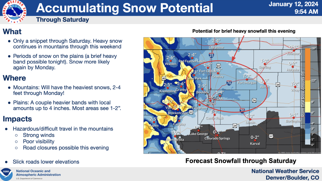
While the big weather story in the Denver metro area, Urban Corridor and eastern plains continue to be the dangerous wind chills over a long stretch of days, these areas could see snowfall accumulations between 2 to 4 inches, said Donaldson.
For those venturing out to Colorado’s high country, temperatures will be slightly warmer than what is expected along the Front Range and plains. Saturday and Sunday’s high temperature should be in the 20s in the mountains.

WEATHER LINKS: Closings and Delays | Latest forecast | Radars | Traffic | Weather Page | 24/7 Weather Stream
You can always watch 24/7 weather, radar and news updates on the free Denver7+ app on your TV.
Click here to watch the Denver7 live weather stream.