


Highlights
- Snow tapering off in the metro area, ending for most areas by midnight.
- The Palmer Divide is on track to get 6-12 inches of snow.
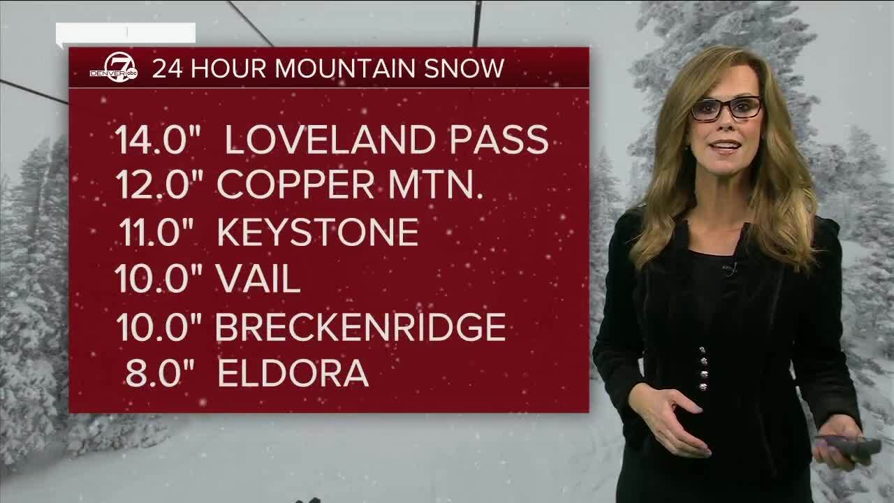
- Significant mountain snow continues through tonight, with travel impacts to the weekend ski traffic.
- The NWS upgraded the areas of eastern Boulder and Jefferson counties to a winter storm warning as up to 7 inches of additional accumulation is possible near the foothills.
DENVER — We've entered the final stages of a winter storm that brought several inches of snow to the Denver metro area Saturday. The National Weather Service in Boulder (NWS) lifted the Winter Weather Advisory that was in place for Saturday- since the snow is moving out.
Early on Saturday several inches of snow had already fallen in parts of the mountains, and heavy, wet snowfall fell in foothills and along the Palmer Divide. What began as rain in parts of the Denver metro below 6,000 feet early Saturday turned into accumulating snow across the Front Range.

A Dense Fog Advisory has also been issued for the Denver metro area for Saturday night into Sunday- visibility may be less than a quarter of a mile overnight. Be very careful driving with our icy roads along with low visibility.
Around noon Saturday, the NWS upgraded the areas of eastern Boulder and Jefferson counties to a winter storm warning as up to 7 inches of additional accumulation is possible near the foothills. The snow began to taper off around late afternoon Saturday for the metro area.

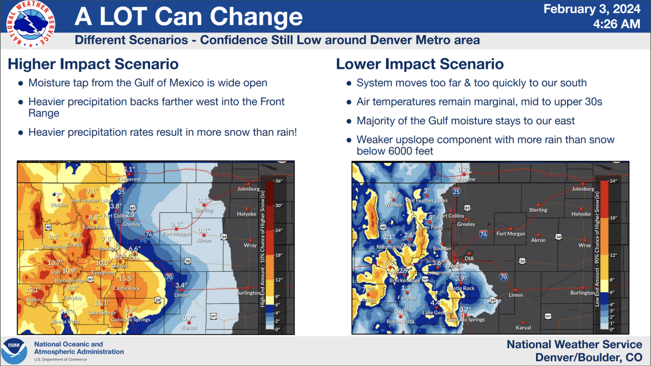
An NWS update early Saturday detailed high- and low-impact scenarios with the storm that could bring anywhere from a dusting to 8 inches in Denver. Even in the low-impact scenario, 6-12 inches of snow was in the forecast for parts of the mountains. In a high-impact scenario, most of the high country could see a foot or more, with even higher totals over the mountain passes.
In addition to the winter storm watch for Denver, multiple other winter weather alerts have been issued ahead of the storm including a winter storm warning through Sunday morning for higher elevation portions of Jackson, Grand, Larimer, Boulder, Gilpin, Clear Creek, Summit and Park Counties. The NWS said heavy snow is possible with accumulations between 8 and 16 inches.
A winter weather advisory for lower elevation areas of Jackson, Grand and Summit Counties where between 4 and 8 inches of snow is possible. The advisory includes the communities of Hot Sulphur Springs, Fraser, Granby, Gould, Kremmling, Grand Lake, Rand, Dillon, Walden and North Park.
“West of Denver and up into the foothills in portions of Douglas, Jefferson, Boulder, Larimer Counties is where we’re going to see some of the heavier snowfall. And definitely above 10,000 feet where we have a number of winter storm warnings,” said Denver7 meteorologist Lisa Hidalgo
Check the latest Colorado winter weather alerts.
The NWS has also upgraded the winter storm watch to a winter storm warning for Elbert, Central and East Douglas Counties where forecasters predicted between 5 and 10 inches of snow.
Communities under the winter storm watch include Fondis, Elbert, Kiowa, Castle Rock and Larkspur, with the NWS expecting the heaviest snow to fall in the Palmer Divide late Saturday morning into the evening hours.
“The Palmer Divide will also be one of those areas south of Denver where we could see some of those heavier totals,” Hidalgo added. “Castle Rock, Castle Pines, Larkspur, south toward Monument Hill could pick up around 5 to 10 inches and then lighter snow, more of a mix and mainly some sloppy conditions for the core of the metro area.”
The NWS warned travel conditions along I-25 south of Castle Rock could become treacherous on Saturday.
Winter weather timeline
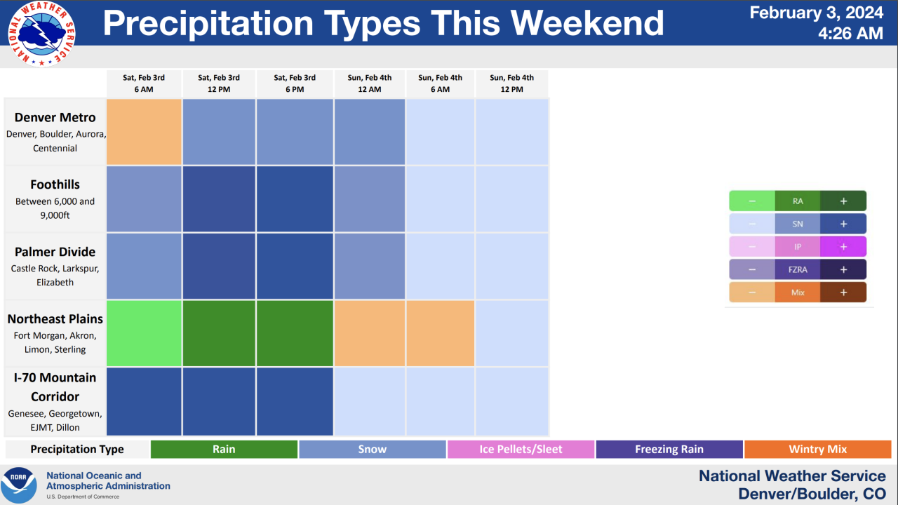
Much of the metro woke up to rain Saturday morning. By noon, the NWS expects that rain to turn to moderate snow, with light snow possible into Sunday morning.
In the mountains, foothills and Palmer Divide, heavier snow was expected early in the day Satuday with light to moderate snow continuing through the night.
The eastern plains may mostly see a soaking with this storm, though a rain/snow mix was possible overnight, according to the NWS.

WEATHER LINKS: Closings and Delays | Latest forecast | Radars | Traffic | Weather Page | 24/7 Weather Stream
You can always watch 24/7 weather, radar and news updates on the free Denver7+ app on your TV.
Click here to watch the Denver7 live weather stream.