


Widespread rain and snow is expected in Colorado and the Denver metro area as a strong storm system is set to roll through the state Tuesday into Wednesday, potentially impacting travel.
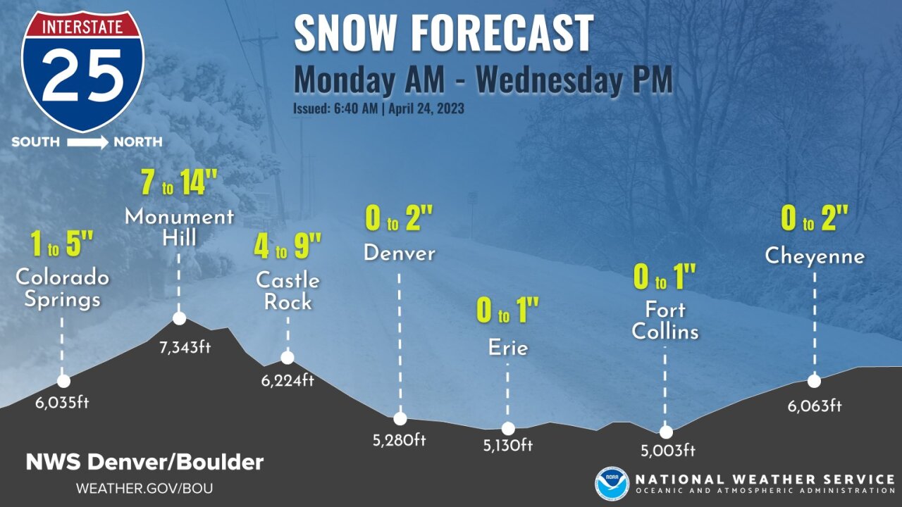
Up to 2 inches of rain mixed with snow is possible along the I-25 Corridor, including in the Denver metro, particularly in the southern and western parts of the area, according to the National Weather Service in Boulder.
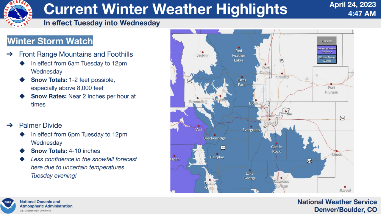
A winter storm watch will go into effect Tuesday extending through Noon on Wednesday with 1 to 2 feet of snow possible above 8,000 feet. The Denver metro is not included in the watch area, but does include Castle Rock to just north of Colorado Springs where 4 to 10 inches of snow accumulation is possible.
“The heaviest snow that we're going to see from this is going to be right at and east of the divide with this kind of pattern that is rolling in.“ said Denver7 morning meteorologist Lisa Hidalgo.
Hidalgo said the smallest elevation change could impact the snow totals along the Palmer Divide.
Other areas included in the winter storm watch include Rocky Mountain National Park, Medicine Bow range, Northern Front Range Foothills, Southern Front Range Foothills and South Park.
Check here to see the full list of communities under the watch.
TRAVEL IMPACTS
Travel could be impacted as heavy snow is expected for the Foothills and Front Range Mountains with most of the snow expected to fall Tuesday afternoon through the early morning hours on Wednesday, the NWS said.
The Palmer Divide (I-25 between Castle Rock and Colorado Springs) is anticipated to be impacted Tuesday evening and there is a potential for a flash freeze Wednesday morning across I-25 in Denver heading north, making travel in the metro area difficult, according to Colorado Department of Transportation (CDOT) officials, who added the public can also expect bursts of heavy snow across the Denver/Fort Collins corridor and northeast plains.
"Road conditions in the mountains will create difficult driving conditions during this storm and motorists are urged to avoid traveling in the high country, if possible," officials said Monday.
Road closures are also extremely likely, officials said, especially in areas that will see heavy snow and wind gusts.
RELATED: How to prepare and drive in Colorado when it snows, in case you forgot
CDOT will have crews plowing the roads ahead of the storm and will remain on the roads clearing them of snow and ice until the storm is out of the area and the roads are safe, a spokesperson said.
TIMING
After Monday afternoon high temperatures reach the mid 60s, a few showers are expected to roll off the foothills making for possible wet roads during the evening commute.
Another round of rain pushes through the overnight hours with snow picking up in the mountains.
Early Tuesday in the metro should see partly sunny skies with snow picking up into the mountains with the better chance of heavy rain and snow forming late Tuesday into the overnight hours Wednesday.
“This low pressure system will move into the perfect position where we get that upslope flow where we get a lot of moisture jammed up against the foothills,” said Hidalgo.
“Denver, south toward Castle Rock and north to Fort Collins and west of there is where we could see some of the heavier totals. First rain, then snow – so those totals are going to be tricky for us in town.”
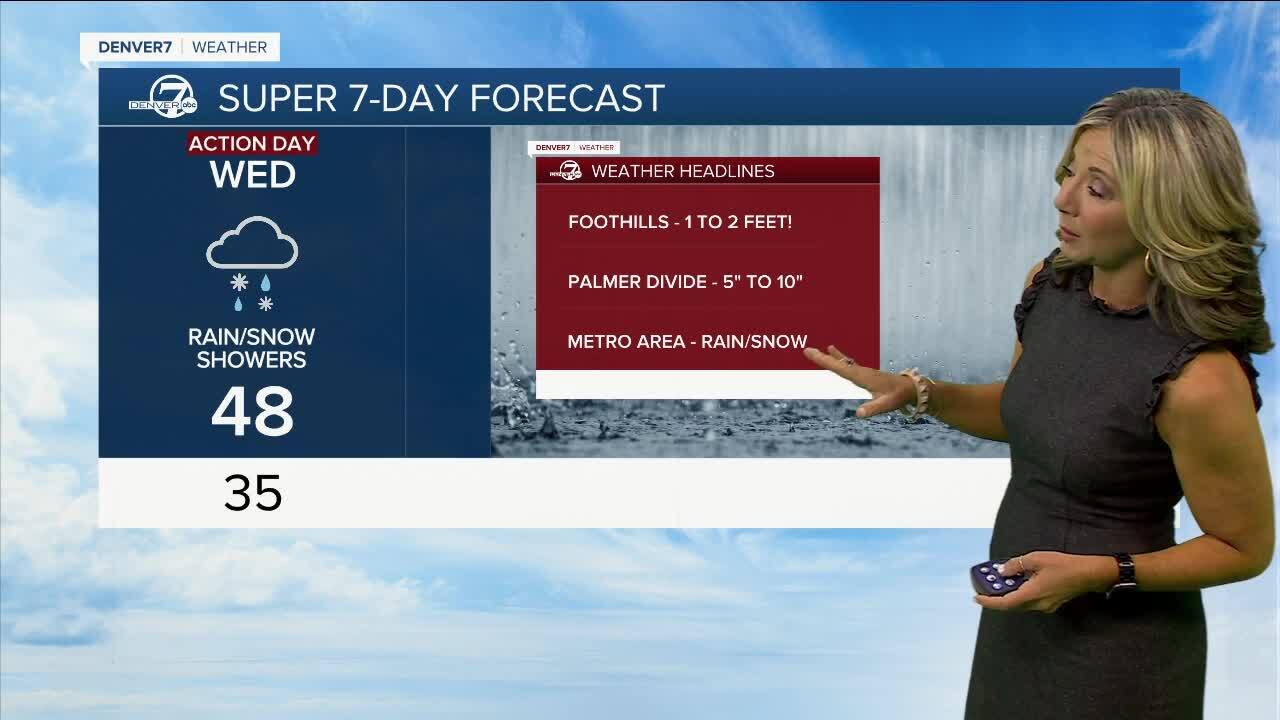
The spring storm system will push southeast late Wednesday with drier weather returning on Thursday.
Looking ahead, the weather drastically improves by the weekend with sun and warmer temps returning to Denver.
Saturday will see mostly sunny skies and a high of 62 degrees. Sunday it should be partly cloudy with a high temperature of 64 degrees.

MORE: Closings and Delays | Latest forecast | Radars | Traffic | Weather Page | 24/7 Weather Stream |
You can always watch 24/7 weather, radar and news updates on the free Denver7+ app on your TV.