


DENVER — A fast-moving blast of snow will roll into Denver late on Friday before quickly moving out of Colorado leaving behind a nice weekend for outdoor activities.
Denver’s snow totals shouldn’t amount to much, but up to 2 inches accumulation is possible along the I-25 corridor.
The system impacting the metro area is the second storm system moving through Colorado with portions of the mountains first seeing snow through Thursday.
A winter weather advisory is in effect through 5 a.m. Saturday for south and east Jackson, north and northeast Grand and northwest Boulder counties where between 6 and 14 inches of snow is possible according to the National Weather Service (NWS) in Boulder.
A winter weather advisory is also in effect through early Saturday morning for west Jackson and Grand Counties for snow accumulation up to 24 inches.
Check the latest Colorado winter weather alerts at this link.
The snow in Colorado’s mountain communities will stick around through Thursday with a few rain showers possible along the eastern plains before Denver’s weather is impacted later on Friday.
“Only 38 degrees tomorrow in Denver with a chance for snow late in the day,” said Denver7 Meteorologist Stacey Donaldson.

Denver’s snow timeline on Friday
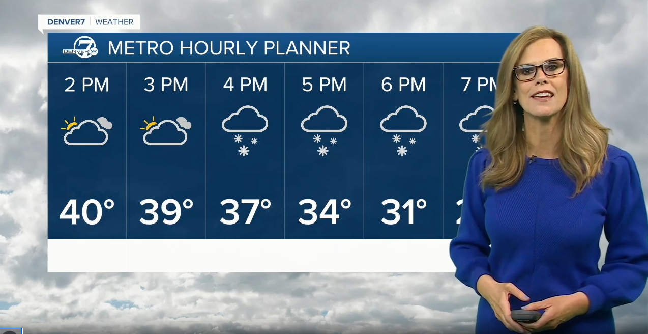
“At noon, not much happening around Denver, up toward Fort Collins a few flakes start flying and then it just races right down across the Front Range by about 7 o’clock Friday,” said Donaldson. “By early Saturday morning, it’s completely gone from the metro and pushing out of the state.”Donaldson said Denver’s weather forecast for snow shows very light amounts through Friday with higher snow totals possible west and north of Denver.
A few flakes are possible starting in the early afternoon hours and temperatures on Friday will only warm into the 30s.
As of Thursday afternoon, there were no winter weather alerts issued for Denver or the Front Range.
While Denver’s snowfall should remain light, the NWS warned cold temperatures could bring slick road conditions after the sun sets on Friday, potentially impacting the evening commute home.
The recent winter blasts in February have helped Denver get a little closer to normal seasonal snowfall totals, but the metro is still around 10 inches behind for the year.
So far in the 2023-2024 snow season, Denver's snow gauge at DIA shows 24.6 inches which is behind the cumulative normal at this point in the year of 34.9 inches.
But halfway through February, Denver is already ahead of what we normally see for the month.
Denver's February snow totals show 9.2 inches which is ahead of the 7.8 inches normally expected during the entire month.
To view the Denver snowfall statistics infographics in fullscreen mode click this link.
Denver’s weekend weather forecast shows mostly sunny skies and a slight warming trend. The afternoon high temperature in Denver on Saturday should reach the mid-40s and then by Sunday, temperatures will be around 10 degrees warmer, with a high of 55 degrees expected.
Even warmer weather is in store for Denver’s forecast by early next week with sunny and warm conditions through at least Wednesday.
Tuesday and Wednesday will see temps in Denver reaching the 60s.

DENVER WEATHER LINKS: Hourly forecast | Radars | Traffic | Weather Page | 24/7 Weather Stream
Click here to watch the Denver7 live weather stream.