


DENVER — The snow in Denver has come to a brief end before at least two more rounds roll through the metro area, starting up again Friday evening with the potential for localized heavier snow expected to stick around through the first half of the weekend.
"It does look like the track of the low pressure system is a little too far south to be a major snow storm for Denver and the Front Range as well as the mountains," said Denver7 Chief Meteorologist Mike Nelson.
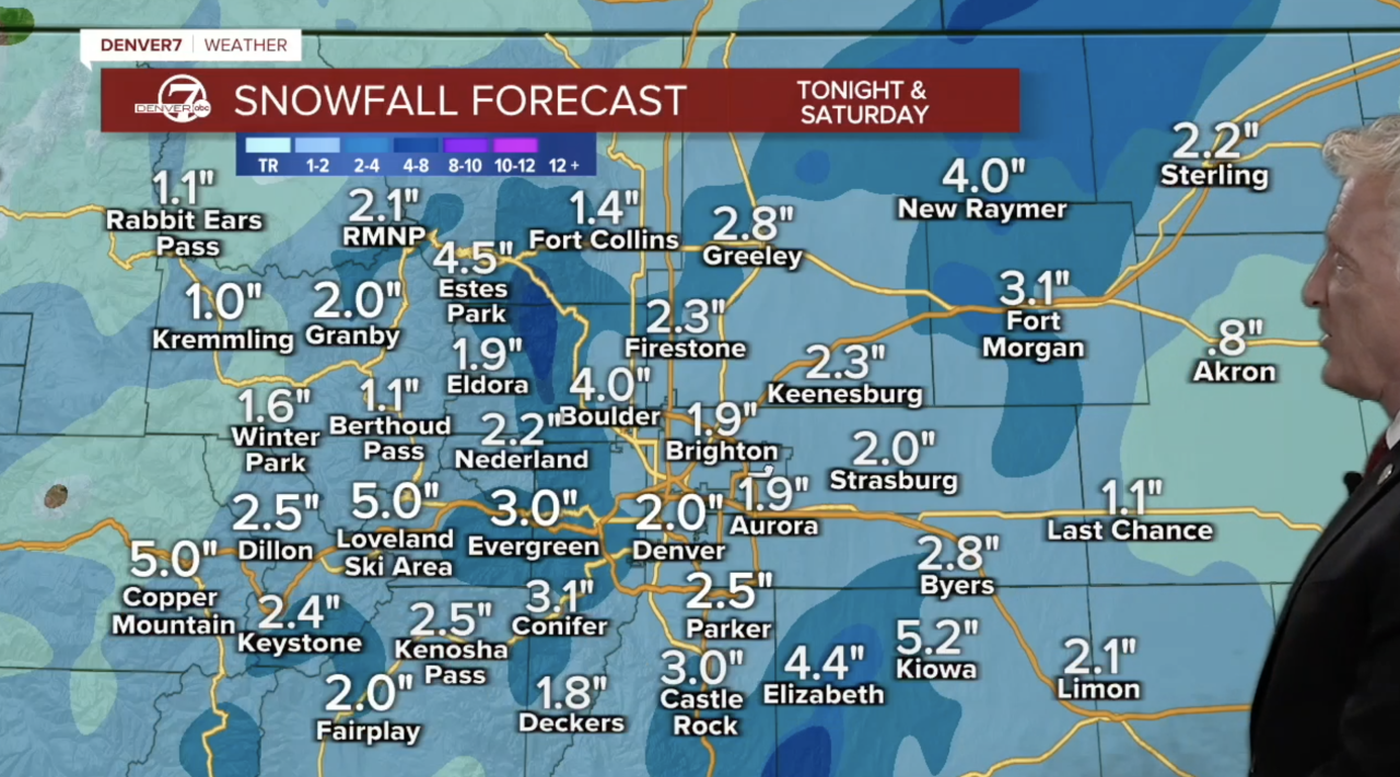
Denver’s updated forecast snow totals show a range of 3 to 6 inches possible across metro communities with isolated areas seeing up to 10 inches of accumulation, according to the National Weather Service (NWS) in Boulder.
In an update from earlier forecasts, Nelson predicted around 2 to 4 inches of snow for Colorado's plains.
“It’s going to be a snowy Saturday for us in Denver and for the entire Front Range but it will be sunny by the time we hit Sunday," said Denver7 Meteorologist Stacey Donaldson.
Friday afternoon, the NWS stressed this winter storm is not as intense as last weekend's storm and confidence is low in the forecast snow accumulation.
“If you`re a snow lover, model trends have not been your friend over the last 12-24 hours as guidance continues to trend towards a less impactful/less widespread snow event for Saturday into Saturday evening,” said the NWS in its Friday morning forecast discussion. "Uncertainty in this forecast has actually increased a little, as the evolution of the snow showers through tonight and Saturday remains in question. Snow on Saturday could focus just south/east of Denver. Stay tuned for updates," the NWS added.
Heavy snow is still possible, but in its Friday afternoon update, the NWS changed the winter storm watch to a winter weather advisory for the Denver metro area, Front Range, Palmer Divide and I-25 corridor.
Colorado's northeast plains were also added to the winter weather advisory starting at 5 p.m. Friday through 11 p.m Saturday
Communities under the winter weather advisory include Boulder, Brighton, Aurora, Evergreen, Loveland, Fort Collins, Arvada, Estes Park, Greeley, Littleton, Longmont, Fort Morgan, Sterling and stretches down toward Colorado Springs.
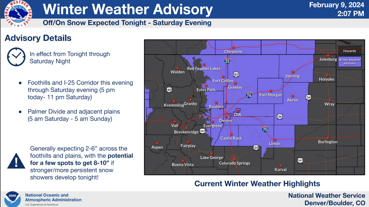
The NWS stressed there is still uncertainty as to where the heaviest snow could fall in the Denver metro area, but the higher snow accumulations could develop if “stronger snow showers develop Friday night,” said the NWS.
As for Denver’s snow forecast timeline, weather forecasters predicted moderate snow to develop between Friday evening and overnight into Saturday morning. Fort Collins, Loveland and communities in northern Colorado could also see more snow impacts and potential heavier accumulations Friday night into Saturday morning, according to the NWS.
Communities south of Denver, including Castle Rock and areas in the Palmer Divide could see slightly higher snow amounts in spots. However the storm plays out, most of the metro area should expect to see at least one inch of snow, the NWS said.
Wind and blowing snow is not a major concern with this storm system.
Check latest Colorado winter weather alerts at this link.
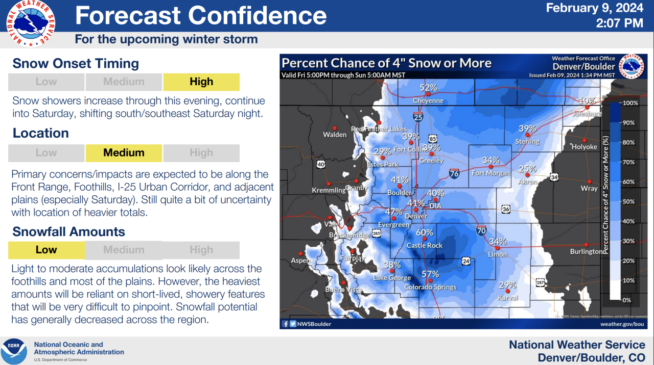
Weather models continued to show less potential for widespread higher snowfall accumulations. “The heaviest amounts will be reliant on short-lived banded features that will be very difficult to pinpoint. Forecast snowfall amounts have decreased across the region this morning,” the NWS wrote in its updated briefing.
Looking at Denver’s snow totals so far this season, the metro stands at around 14 inches behind the normal cumulative total heading into February.At Denver International Airport, Denver’s official weather reporting station, 20.9 inches of snow has fallen this year compared to 34.9 inches we’d normally see by this time of the season.
To view the Denver snowfall statistics infographics in fullscreen mode click this link.
Denver’s normal February monthly snowfall total is 7.8 inches and after last weekend’s snow storm, Denver’s snow gauge has recorded 5.5 inches.
Colder temperatures will settle across Denver for the weekend. After Friday’s afternoon high of 42 degrees, Saturday will barely warm to the freezing mark before skies clear out on Sunday.Sunday’s afternoon high temp in Denver is expected to be 35 degrees.
The overnight lows in Denver will dip into the mid to upper teens.After the weekend snow in Denver, next week conditions will dry out and warmer temps will arrive with afternoon highs warming into the low to mid 50s by Wednesday.


DENVER WEATHER LINKS: Hourly forecast | Radars | Traffic | Weather Page | 24/7 Weather Stream
Click here to watch the Denver7 live weather stream.