


DENVER – Severe storms could drop large, damaging hail over Colorado’s far northeastern plains with rain and thunderstorms possible for Denver Sunday afternoon as significant snow rolls over the high country where a winter weather advisory is in effect.
“Sunday afternoon, we do have the chance for seeing scattered thunderstorms, so some rain on the way for the Denver metro area with rain chances arriving mainly after 2 o’clock,” said Denver7 weather forecaster Katie LaSalle.
While Denver should see a few showers or isolated storms, the severe weather risk increases as you head farther north and east into the plains.

An area from Limon through Deer Trail up to Fort Collins is under a marginal risk for severe storms as Fort Morgan through Flagler and Burlington is under a slight risk.
Sterling, Akron and and Wray to Julesburg are under an enhanced risk of severe storms, according to the National Weather Service (NWS) in Boulder.
“Thunderstorms will develop across the lower elevations shortly after midday today, mainly north of I-70. As the storms move northeast, the environment will become more favorable for these to become severe,” wrote NWS forecasters.
There main storm risk is hail where some storms could drop large, damaging hail and an isolated tornado is also possible, according to the NWS, which said the greatest risk for severe weather will be between 2 p.m. and 9 p.m. on Sunday.

While the active weather pattern will break storms to the Front Range and plains, portions of Colorado’s mountains will see significant snow where a winter weather advisory is in effect until 6 a.m. on Monday for the highest elevations potentially impacting travel on mountain passes.
“More widespread snow really picks up steam in the High Country late tonight through early tomorrow with upwards of 5 to 10 inches of accumulation over 10,000 feet,” added LaSalle.

Today's Forecast
A severe weather outbreak for Colorado with tornadoes near Denver
Portions of Jackson, Grand, Boulder, Gilpin, Clear Creek, Summit and Park Counties above 9,000 feet are under the winter weather advisory.Areas of blowing and drifting snow are possible with wind gusts up to 50 mph in the highest elevations.
“Use caution if you are traveling through the high mountain passes,” wrote the NWS.
Check the latest Colorado weather alerts at this link.
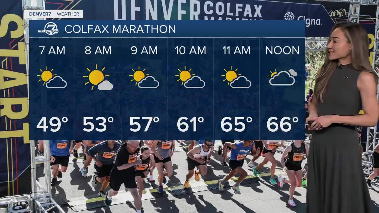
The Denver metro area is not under a weather alert where Sunday’s high temperature will reach the low 70s as thousands of runners take on the Colfax Marathon.
Stay with Denver7 for weather alerts and download the Denver7 mobile app to keep a track of Colorado's weather radar.
DENVER WEATHER LINKS: Hourly forecast | Radars | Traffic | Weather Page | 24/7 Weather Stream
Click here to watch the Denver7 live weather stream.