


DENVER — Denver’s predicted snow totals for Thursday’s storm could reach a foot or more in some locations as the powerful winter storm remains on track to dump heavy, wet snow starting late Wednesday and continuing throughout the day Thursday, likely causing dangerous travel conditions in the metro and across the state.
Downed tree branches and power lines leading to power outages are a concern with this storm. Multiple Denver-area and Colorado school districts announced closures for Thursday.
“This will likely be the biggest storm we’ve seen officially in Denver since March of 2021 when we had over 25 inches within 2 days,” said Denver7 Meteorologist Lisa Hidalgo. “Wet roads expected in the metro tonight, snow covered conditions tomorrow. Expect to see a much tougher drive tomorrow and we will likely see some delays and maybe some closures.”
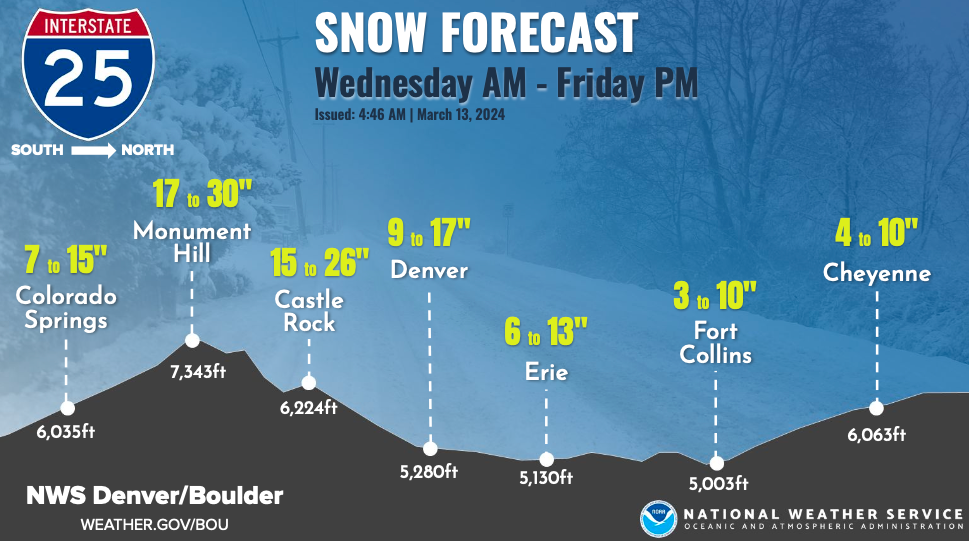
Denver’s overall snow totals look to be in the 8 to 16 inch range across metro communities with up to 20 inches in the western suburbs, according to the National Weather Service (NWS) in Boulder.

Updated Denver metro, Colorado closings and delays at this link.
“As you get closer to Denver it’s going to be closer to, if not over a foot of snow with some of those heavier totals on the west side of Denver, west of I-25 and south along the Palmer Divide,” said Hidalgo.
A plethora of winter weather alerts are set to go into effect across Colorado and not much has changed in terms of the latest forecast update as of Wednesday evening.
All Denver metro communities will go under a winter storm warning starting at 9 p.m. Wednesday through 6 a.m. Friday where in addition to the heavy snow, wind gusts up to 35 mph are expected.
“Travel will be very difficult to impossible, especially late tonight through Thursday night. Scattered power outages will be possible,” said the NWS.

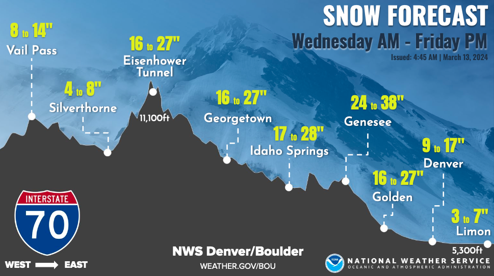
A winter storm warning will also go into effect starting at Noon Wednesday for Colorado’s higher elevations including portions of Jackson, Larimer, Boulder, Grand, Gilpin, Clear Creek, Summit, Park, Larimer and Douglas Counties where snow could accumulate between 18 to 36 inches.The NWS said the eastern slopes along the Front Range could see up to 4 feet of snow.
Castle Rock, Kiowa, Larkspur and other communities south of Denver will go under a winter storm warning at 9 p.m. Wednesday where heavy, blowing snow accumulating between 14 to 24 inches is possible.
“Near blizzard conditions are possible over the Palmer Divide late tonight through Thursday,” added the NWS.
Check latest Colorado winter weather alerts at this link
DENVER SNOW TIMELINE
After warming to near 50 degrees Wednesday afternoon, showers are expected to develop in Denver before the major snow event.
“What we do see precipitation-wise this afternoon is first rain then switching over to that snow tonight,” said Hidalgo. “By this afternoon, in time for the commute, you’re likely going to see some wet roads and it might become a little slushy where we see more of a mix along the Palmer Divide and then also up into the Foothills.”
.
Light snow showers are possible in the metro between 6 p.m. and midnight.
“Overnight it switches over to all snow across the metro a bit of a mix out east,” said Hidalgo. “The brunt of our snow is going to be throughout the day Thursday but it’s going to keep coming.”
The heaviest snow is expected to fall between midnight through 6 p.m. Thursday with up to 1 to 2 inches of snowfall per hour possible in Denver for much of the morning, according to the NWS.
In Colorado’s foothills, the heavy snow is expected to start at 6 p.m. on Wednesday where up to 3 inches per hour of snowfall is possible.
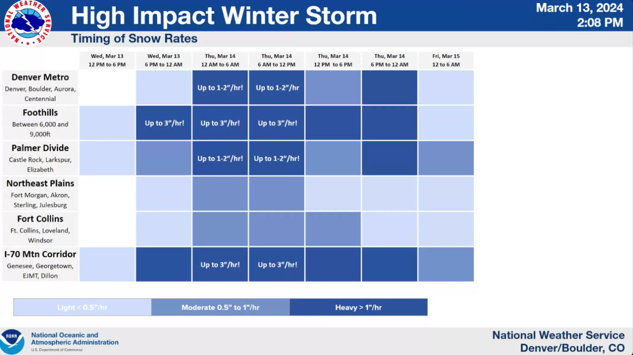
On the Palmer Divide and through Castle Rock, heavy snow should begin overnight through Thursday morning with snowfall rates up to 2 inches per hour.
The NWS said highway closures were expected with this storm as the I-70 mountain corridor will see heavy snow Wednesday evening through late Thursday.
The NWS added motorists should expect difficult to impossible travel conditions along I-70 from Denver to the Eisenhower Tunnel and I-25 from Denver to Colorado Springs.
Along Colorado’s plains, snowfall totals were expected to be less than the metro but the NWS said there is some possibility of heavier snow “as far east as Fort Collins through Limon.”
POTENTIAL SNOW TOTALS ACROSS DENVER METRO, OTHER COLORADO COMMUNITIES
The NWS provides a probabilistic snowfall tool that shows low-end, expected and high-end snowfall accumulations. While the tool is "experimental", the NWS says it can give an overall look at possible snow totals.
Here are potential expected snowfall totals:
- Downtown Denver: 13"
- Denver International Airport: 11"
- Boulder: 18"
- Georgetown: 25"
- Castle Rock: 24"
- Kiowa: 17"
- Central City: 29”
- Winter Park: 20"
- Walden: 3"
- Lakewood: 21"
- Fort Collins: 6"
- Limon: 4"
- Sterling: <1"
- Fort Morgan: <1"
- Fairplay: 9"
- Breckenridge: 6"
- Vail Pass: 8"
- Akron: 2"
- Greeley: 2"
- Alamosa: 4"
- Colorado Springs: 11"
- Durango: 2"
- Pueblo: 4"
- Trinidad: 8"
The NWS’ prediction tool also provides high-end potential snow totals, here’s the latest:
- Downtown Denver: 20"
- Denver International Airport: 17"
- Boulder: 29"
- Georgetown: 28"
- Castle Rock: 32"
- Kiowa: 26"
- Central City: 35”
- Winter Park: 25"
- Walden: 7"
- Lakewood: 29"
- Fort Collins: 14"
- Limon: 10"
- Sterling: 3"
- Fort Morgan: 5"
- Fairplay: 13"
- Breckenridge: 8"
- Vail Pass: 11"
- Akron: 6"
- Greeley: 8"
- Alamosa: 7"
- Colorado Springs: 22"
- Durango: 7"
- Pueblo: 9"
- Trinidad: 14"

Local
Denver weather in March: Snowiest month, blizzards and the start of spring
While this powerful storm will bring heavy snow, it is not expected to plunge temps well below freezing.
Denver’s 7-day forecast shows Thursday’s morning low dropping to around 27 degrees and the high temperature around 35 degrees.
Friday’s morning low temperature in Denver will be around 24 degrees.
After morning flurries on Friday, skies are expected to clear out through the day and temperatures will slowly begin to rebound.
"Gradually see things dry up early friday morning few lingering light snow showers on Friday with sunshine breaking out late in the day," said Hidalgo.
Saturday and Sunday in Denver, expect a mix of partly cloudy and sunny skies with temperatures warming into the upper 40s before rebounding to nearly 60 degrees and plenty of sunshine by Monday.
So how will this snowstorm impact Denver's overall snow totals for the 2023-24 winter season? While snow totals this season have lagged behind normal totals, a couple of storms in February helped the metro rebound, but this big March should make a big difference.
"It looks like this next winter storm is going to be the biggest one we've seen in three years in Denver," said Hidalgo.
Denver normally sees 11.5 inches of snow in March, according to NWS data, meaning if this storm were to drop 12 inches or more at DIA, the metro could officially hit its monthly normal snowfall total in just one storm.

Denver7 | Weather
March snow in Colorado: A reminder of just how much a foot of snow weighs
How does this storm compare to other big snowstorms? Many of you will remember the big snow dumper of March 2021.
"To the date, on March 13 of 2021, we had just over 7 inches and the following day close to 20 inches of snow. It doesn't look like we'll see that much officially out at the airport, but we are going to see some pockets up through the foothills heavier than that," said Hidalgo
To view the Denver snowfall statistics infographics in fullscreen mode click this link.

DENVER WEATHER LINKS: Hourly forecast | Radars | Traffic | Weather Page | 24/7 Weather Stream
Click here to watch the Denver7 live weather stream.