


DENVER — How much snow can you expect in Denver on Tuesday as a major winter storm rolls through the state?
Snow is expected Tuesday morning potentially impacting the I-25 corridor through metro Denver and you can expect very strong winds from the north.
SNOW TIMELINE
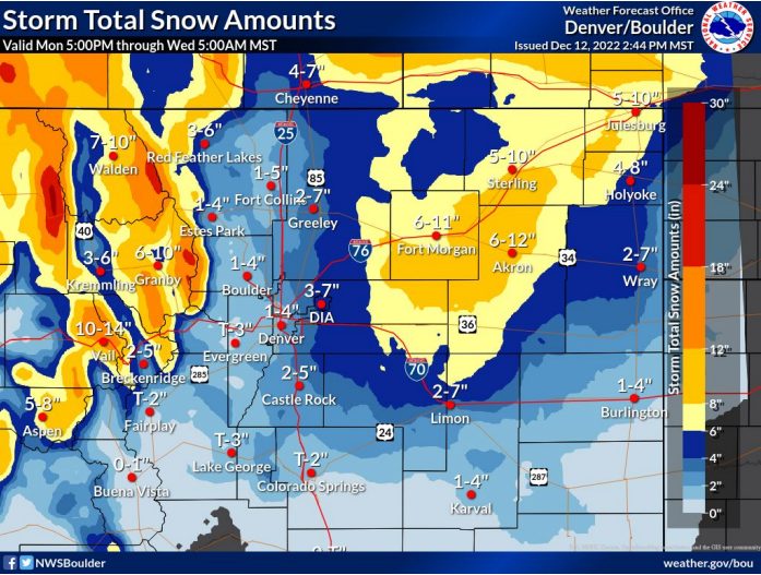
The latest forecast calls for 2 to 4 inches of snow by the time it’s all said and done. The Denver metro area will be under a Winter Weather Advisory starting at 9 p.m. Monday lasting through at least 3 p.m. Tuesday.
Communities in the advisory include Fort Collins, Denver, Castle Rock and Greeley. Some snow could develop overnight and could be heavy at times Tuesday morning according to the National Weather Service in Boulder.
The commute to work Tuesday could be dicey in Denver with potentially slick road conditions in some areas.
The biggest weather impacts should be in the mountains and on the plains north and east of Denver. Blizzard conditions are possible east of Denver and toward Akron, Sterling and Fort Morgan, according to the NWS.
Heavy snow up to 10 inches and gusty winds could combine with very low visibility hampering travel in these area Tuesday morning and throughout the day. The blizzard will also impact eastern Wyoming and western Nebraska.
The NWS is recommending drivers to avoid traveling east and northeast of Denver until after the storm passes.
Here is a roundup of the other winter weather advisories currently affecting Colorado:
- Fort Collins, Denver, Castle Rock, and Greeley. The worst conditions will be east of Interstate 25 and also north of Fort Collins: 9 p.m. Monday to 3 p.m. Tuesday.
- Hugo, Limon, Agate and Matheson: Begins midnight Monday, ends midnight Tuesday
- West Elk and Sawatch mountains: 11 a.m. Monday, ends at 11 p.m. Tuesday
- Gore and Elk Mountains/Central Mountain Valleys: 11 a.m. Monday, ends at 5 p.m. Wednesday
- Elkhead and Park Mountains: 11 a.m. Monday, ends at 5 p.m. Wednesday
- Northwest San Juan Mountains: Ends at 11 p.m. Monday
- Flat Tops: Ends at 5 p.m. Wednesday
- Debeque to Silt Corridor and Central Colorado River Basin: Ends at 5 a.m. Tuesday
- Upper Yampa River Basin: 11 a.m. Monday, ends at 5 p.m. Wednesday
- Central Yampa River Basin: 11 a.m. Monday, ends at 5 p.m. Wednesday
- La Garita Mountains above 10,000 feet: Ends at 11 p.m. Monday
- Western Mosquito Range and eastern Sawatch Mountains above 11,000 feet: 11 a.m. Monday, ends at 5 a.m. Wednesday
- Lake County below 11,000 feet and western Chaffee County between 9,000 and 11,000 feet: 11 a.m. Monday, ends 5 p.m. Tuesday
Check the latest winter weather alerts/advisories from the National Weather Service.

WEATHER LINKS
Closings and Delays | Latest forecast | Radars | Traffic | Weather Page | 24/7 Weather Stream
You can always watch 24/7 weather, radar and news updates on the free Denver7+ app on your TV.