


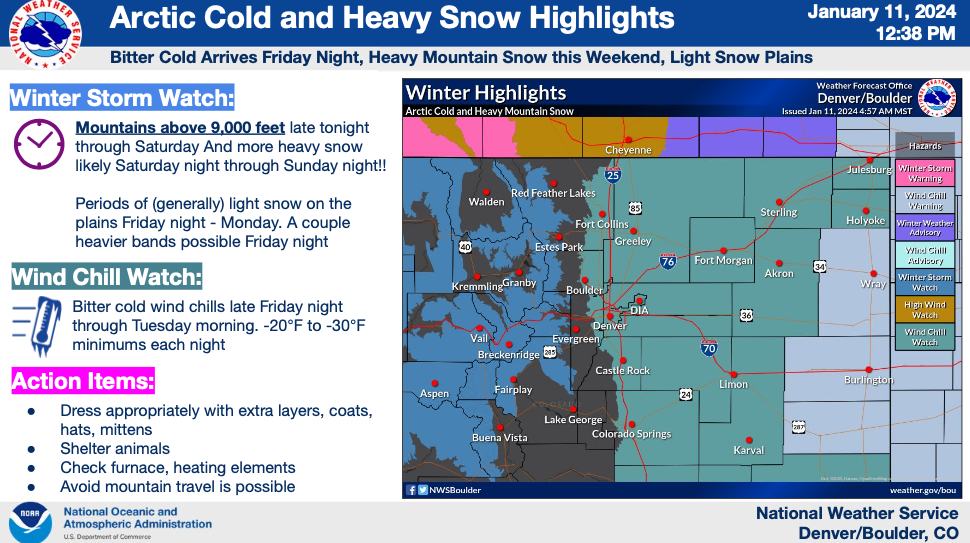
DENVER — A major blast of Arctic air will blow through Colorado this weekend through Monday not only dropping low temperatures well below zero, but also bringing dangerously cold wind chills of 20 to 30 degrees below zero for several days.
It's a type of storm system Colorado only sees one to two times a year.
The nosedive in Colorado’s temperatures will be accompanied by heavy snow in the mountains and light to moderate snow in the Denver area, the Front Range and the eastern plains.
While some of the higher elevations could see up to two feet or more of snow, the plunge in the wind chills for an extended period of time remains the biggest concern.
“A lot of negative feelings in this forecast,” said Denver7 Chief Meteorologist Mike Nelson. “The Arctic front arriving late Friday pours southward Saturday with very cold air coming in and we’ll get periods of snow winding into the mountains and bitter cold across all of Colorado.”
Denver metro temperature timeline
Friday will bring the best conditions over the next 5 days with a high of 28 degrees and partly cloudy skies expected in Denver. Then after the Arctic front blows through on Friday, the overnight low into Saturday will drop to -2 degrees only warming up to 12 degrees with light snow on Saturday.
Temperatures plunge even further on Sunday with Denverites waking up to a low temperature of only -7 degrees and warming up (if you can call it that) to barely above zero degrees. A chance of flurries sticks around Sunday in the metro area.
The overnight low Sunday into Monday morning will drop to around -5 degrees and the afternoon high is expected to be 15 degrees.
While the thermometer readings will drop, the combination of wind and actual temperatures will come together to bring dangerous wind chill readings that will impact anyone outside, even if just for a few minutes.
The extreme wind chills will create an environment in which frostbite is a concern to anyone outside, even if just for a few minutes.
Colorado wind chill forecast
The National Weather Service (NWS) in Boulder on Thursday updated the wind chill forecast which showed the potentially dangerous conditions would extend into Tuesday morning.
The wind chill was expected to drop below zero degrees in the metro area beginning in the overnight and early morning hours on Saturday and remain well below zero through at least 6 a.m. Tuesday.
Other areas along the Front Range were expected to see the wind chill drop below zero degrees earlier on Friday evening.
NWS forecasters warned the temperature outlook had been lowered with every update since Monday and it was probably expected temps could be colder than predicted.
"Limit yourself outside as much as humanly possible," said Greg Heavener, NWS Warning Coordination Meteorologist. "Temperatures won't recover to above freezing until Tuesday at the earliest."
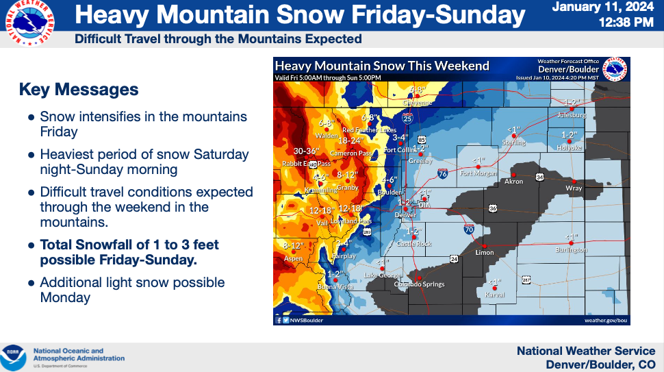
As temperatures tumble, the NWS added a prolonged period of snow, at times heavy, will continue over the weekend into Monday.
“Snowfall totals over the next few days will likely be around 2 to 4 inches for the metro area and it looks like the brunt of that is going to fall this weekend into Monday,” said Denver7 Meteorologist Lisa Hidalgo. “Obviously some much heavier snow for the mountains, we could be adding on a few more feet in spots by next Monday.”
The NWS said narrow bands of snow could develop along isolated areas Colorado's northeastern plains potentially dropping 1 inch of snowfall per hour. While the snow was not expected to be "wet and sloppy", Heavener said slippery conditions could develop on roads due to the prolonged period of below freezing temperatures.
Light to moderate snow is expected Friday in Colorado's mountains with accumulations picking up both Saturday and Sunday.
The NWS shared these potential snowfall totals for Colorado’s northcentral mountain communities:
- Bear Lake RMNP: 26”
- Cameron Pass: 26”
- Eisenhower Tunnel: 20”
- Fremont Pass: 16”
- Granby: 14”
- Rabbit Ears Pass: 35”
- Vail Pass: 19”
The above totals are the “best forecast” from the NWS, but the actual range of accumulations for each location could be much lower or higher.
Multiple winter weather alerts have already been issued ahead of the Arctic front including a winter storm warning in effect starting at 11 p.m. through 5 p.m. Saturday for portions of Jackson, Grand, Larimer, Boulder, Gilpin, Clear Creek, Summit and Park Counties.
The NWS said heavy snow, accumulating between 6 and 14 inches was possible and wind gusts up to 70 mph at higher elevations.
Up to 24 inches of snowfall was possible in the Park Range.
The Denver metro area will go under a wind chill warning Friday at midnight until 11 a.m. Tuesday. The warning includes the cities of Arvada, Littleton, Boulder, Brighton, Castle Rock, Aurora, Highlands Ranch, Golden as well as a large portion of east central, north central and northeast Colorado, said the NWS.

Check latest Colorado winter weather alerts
If you're looking for any sign of good news in terms of temperatures, seasonable averages return but not until Wednesday of next week when Denver is expected to see a high of 40 degrees and milder conditions.

WEATHER LINKS: Closings and Delays | Latest forecast | Radars | Traffic | Weather Page | 24/7 Weather Stream
You can always watch 24/7 weather, radar and news updates on the free Denver7+ app on your TV.
Click here to watch the Denver7 live weather stream.