


DENVER — A second round of snow will come to an end this morning across I-25 corridor, but there are a few weather impacts with wet and slushy conditions reported across the metro.
While Denver is not under any weather alerts, a winter weather advisory remains in effect for portions of Elbert and Douglas Counties as well as the High Country.
We're tracking the latest weather conditions, alerts and travel impacts in the Colorado weather blog below. Refresh this page for updates.
LINKS: Closings and Delays | Latest forecast | Radars | Traffic | Weather Page | 24/7 Weather Stream
Friday, January 9
7:20 a.m. | Hwy 285 reopened | A semi-truck was blocking both lanes of southbound Hwy 285 between Parmalee Gulch and Hwy 8. The highway is now back open.

7:02 a.m. | New I-70 crash | A new crash on I-70 westbound near Kipling is impacting the right lanes.
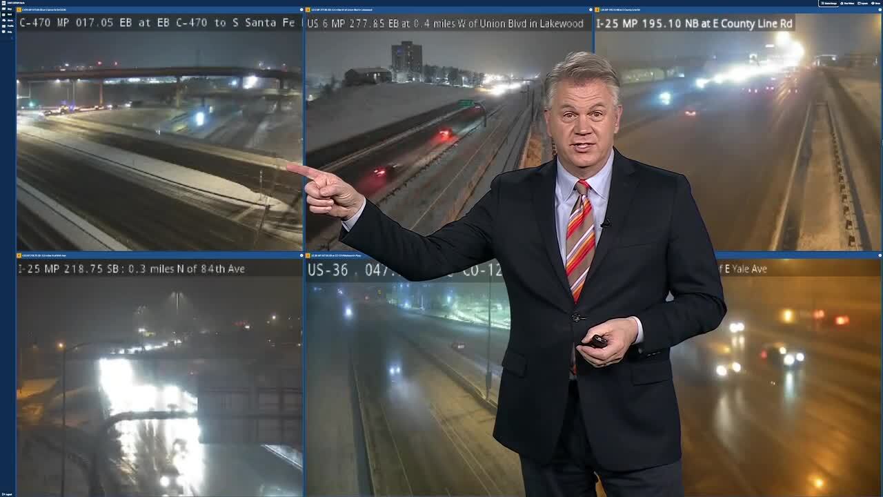
6:54 a.m. | I-70 crash | Denver7 Traffic Expert is tracking a new wreck on I-25 southbound at I-70, which is off to the side. He said there's also a new crash on I-76 westbound near 104th/Hwy 85 that has several lanes blocked.

6:40 a.m. | New crashes reported | A last blast of snow is bringing new problems to the roads. A new crash has been reported on I-25 southbound after Ridge Gate and before Castle Pines Parkway. There's also a new one on the eastbound I-70 lanes near York with slowing from I-25.

6:30 a.m. | Snowier roads north | A band of snow has rolled across the northern sections of the metro and Denver7 Traffic Expert Jayson Luber said he's noticing slower traffic on the north side of the metro and in the Boulder area.
Slower travel times should be expected on Hwy 36 and 93. Here's a look at downtown Boulder.

6:15 a.m. | Some road improvement | Here's an update from Denver7 Traffic Expert Jayson Luber: "I continue to see improvement on the drive as the snow pulls away to the south. New problem reported out in Lakewood at Colfax and Kipling in lanes."

6:07 a.m. | RTD N Line | If you take RTD's N line, be advised there is up to a 20 minute delay due to a signal problem this morning. Updates here.
6:00 a.m. | Crash update | Denver7 Traffic Expert is monitoring a crash on 84th at I-25. He said no matter where you travel in the metro area this morning, pay extra attention to bridges which "are still very slick."

5:45 a.m. | Slick conditions south | Denver7 reporter Laura Lennon is monitoring conditions on I-25 south near Castle Rock and said she saw a driver spin out on the interstate. Roads there are slick in areas. Watch her live report in the video player below.
5:30 a.m. | A look at roads |Denver7 Traffic Expert Jayson Luber has been tracking road conditions. You'll likely find wet and slushy roads in the Denver area with more hazardous travel on the south and west sides of the metro area. Luber said it's mostly wet in the Denver Tech Center.
"It doesn't have to be too terrible or snow covered to be slick," he said, adding that drivers should pay extra attention on bridges which will likely be slick.
5:10 a.m. | Forecast update |Meteorologist Chris Tomer says some snow is still falling on west and south sides of Denver, with bands hanging on along the Palmer Divide as conditions will dry out the metro area later this morning and afternoon.

5:00 a.m. | Latest closings | Just a few weather-related delay early this morning below:
- Anythink LibrariesOpening at 11:00 AM
- Elbert School District 200Delayed 2 hours
- Valor Christian High SchoolOpening at 9:30 AM
Thursday, January 8
10:30 p.m. | Forecast update | Snow showers will stay hit-or-miss through this evening, but coverage will pick up overnight as a cold front slides through from the south.
Denver7 meteorologist Stacey Donaldson said most areas along the I-25 corridor, including Denver, can expect around a half inch to 2 inches of snow by Friday morning.
Watch the latest update in the video player below:
3:30 p.m. | Forecast update | A second storm system will roll through Colorado bringing more cold air and snow for the mountains and Front Range. Period of snow should be expected Thursday evening and overnight into Friday morning. Denver7 meteorologist Stacey Donaldson said to expect tough travel conditions in the High Country and into southern Colorado.
The snow will clear out Friday morning, said Donaldson.

12:30 p.m. | Heavy snow band | The NWS said to expect heavy snow along C-470 in the southern Denver metro area.
"Use caution as this band of heavy snow moves across. It won't last more than 20 minutes, but some slush/snow on roads with reduced visibility," wrote NWS forecasters.

12:30 p.m. | Forecast update | A band of snow is rolling across the Denver metro area and the NWS said to expect "several lulls or periods of no snow" during the afternoon hours.
"Roads will be mostly wet at lower elevations (below 6,000 ft) during the day, colder temps/more snow will create poor travel conditions tonight into Friday morning commute, possibly starting for late pm commute," added the NWS.

Click here to watch the Denver7 live weather stream.