


DENVER — A few thunderstorms are turning severe on Sunday, particularly on Colorado’s northeastern plains, where large hail up to 2 inches in diameter and damaging wind gusts are a concern.
The severe weather potential returns Monday with isolated tornadoes a possibility.
The Denver7 news team is tracking the latest Colorado weather alerts and conditions across northeastern Colorado and the Denver metro area.

Today's Forecast
Denver weather: Severe thunderstorm watch for NE Colorado until 8 p.m.
Refresh this page for updates and keep checking back for new details.
LINKS: Latest forecast | Radars | Traffic | Weather Page | 24/7 Weather Stream
Sunday, July 6
8:15 p.m. | Storms pushing out, severe t-storm watch trimmed | Most of Northeastern Colorado is now out of a severe thunderstorm watch, which expired at 8 p.m. Sunday, but the following counties remain in a severe t-storm watch until 10 p.m.:
- Bent
- Crowley
- Kiowa
- Otero
- Prowers
- Pueblo
6:54 p.m. | Severe storm Washington County| A line of storms from Burdett to Sterling and Akron is triggering a severe thunderstorm warning where quarter sized-hail and 60 mph wind gusts are possible. The line is moving SE at 15 mph and the warning lasts until 7:45 p.m.

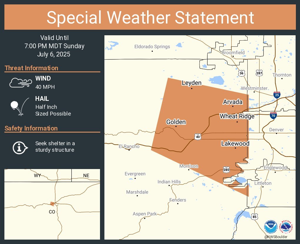
6:50 p.m. | Storm west of Denver| A strong cell will impact southwestern Denver, NW Arapahoe and SW Adams Counties where penny sized-hail is possible and 40 mph wind gusts.
The storm was over the Wheat Ridge community, said the NWS.

6:13 p.m. | Jefferson County storm| half inch-sized hail and 50 mph wind gusts radar-indicated on a strong storm near Golden.
"At 612 PM MDT, Doppler radar was tracking a strong thunderstorm near Golden, or 16 miles west of Denver, moving southeast at 20 mph," read the NWS alert.
The storm is expected to impact NE Jefferson County until 7 p.m.
Locations impacted: Lakewood, Arvada, southern Westminster, northern Littleton, Wheat Ridge, Golden, Morrison, Red Rocks Park, Edgewater, Mountain View, Pleasant View, and Genesee.
6:10 p.m. | Strong line impacting NE Colorado| Half inch-sized hail and 50 mph wind gusts are possible along a line of storms pushing through northeastern Colorado.
"At 6:05 PM MDT, Doppler radar was tracking an area of strong thunderstorms extending from near Peetz to 6 miles southeast of Roggen, or extending from 26 miles north of Sterling to 27 miles west of Fort Morgan, moving southeast at 30 mph," read the NWS alert.
A severe thunderstorm watch remains in effect until 8 p.m. for many Colorado counties.

5:45 p.m. | Severe storm near Colorado Springs| Up to 2 inch-sized hail was possible with a storm over SW Colorado Springs. The cell is moving south at 10 mph, said NWS Pueblo.
The warning is in effect until 6:15 p.m.

5:37 p.m. | Severe t-storm warning Yuma County| Ping pong-sized hail is possible in a severe storm located 9 miles north of Wray, said the NWS.
The storm is moving SE at 10 mph and could contain 60 mph wind gusts.
5:02 p.m. | Severe thunderstorm warning continues | LEast Central Logan and West Central Phillips Counties are under a severe thunderstorm warning until 5:45 p.m. for a cell near Haxtun, moving NW at 5 mph.
Two inch hail and wind gusts up to 60 mph are possible with this storm.
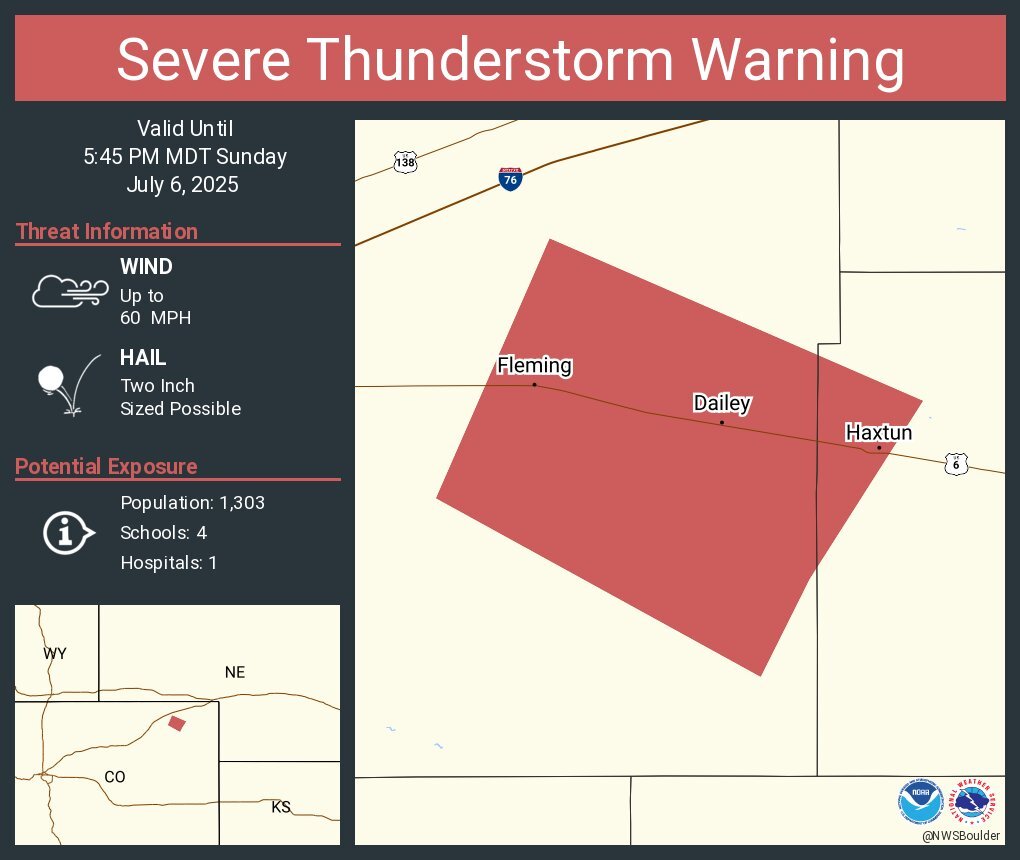

4:27 p.m. | Severe thunderstorm warning | Two inch-sized hail and 60 mph wind gusts are possible in a cell located near Haxtun, said the NWS.
East Central Logan and Western Phillips Counties are in the warning until 5 p.m.
4:15 p.m. | Large hail possible | A severe thunderstorm warning has been issued for a cell over Haxtun for potential quarter sized-hail.
East Central Logan and Western Phillips Counties are in the warning until 5 p.m.

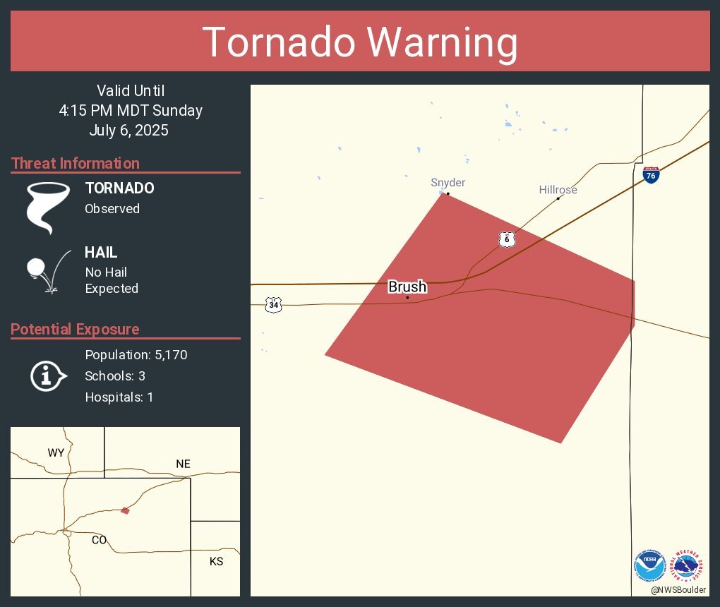
4:04 p.m. | Tornado warnings cancelled | The NWS cancelled the tornado warning for East Central Morgan County and that a "tornado which occurred south of Hillrose has dissipated."
Local storm reports indicated multiple sightings of a landspout tornado.
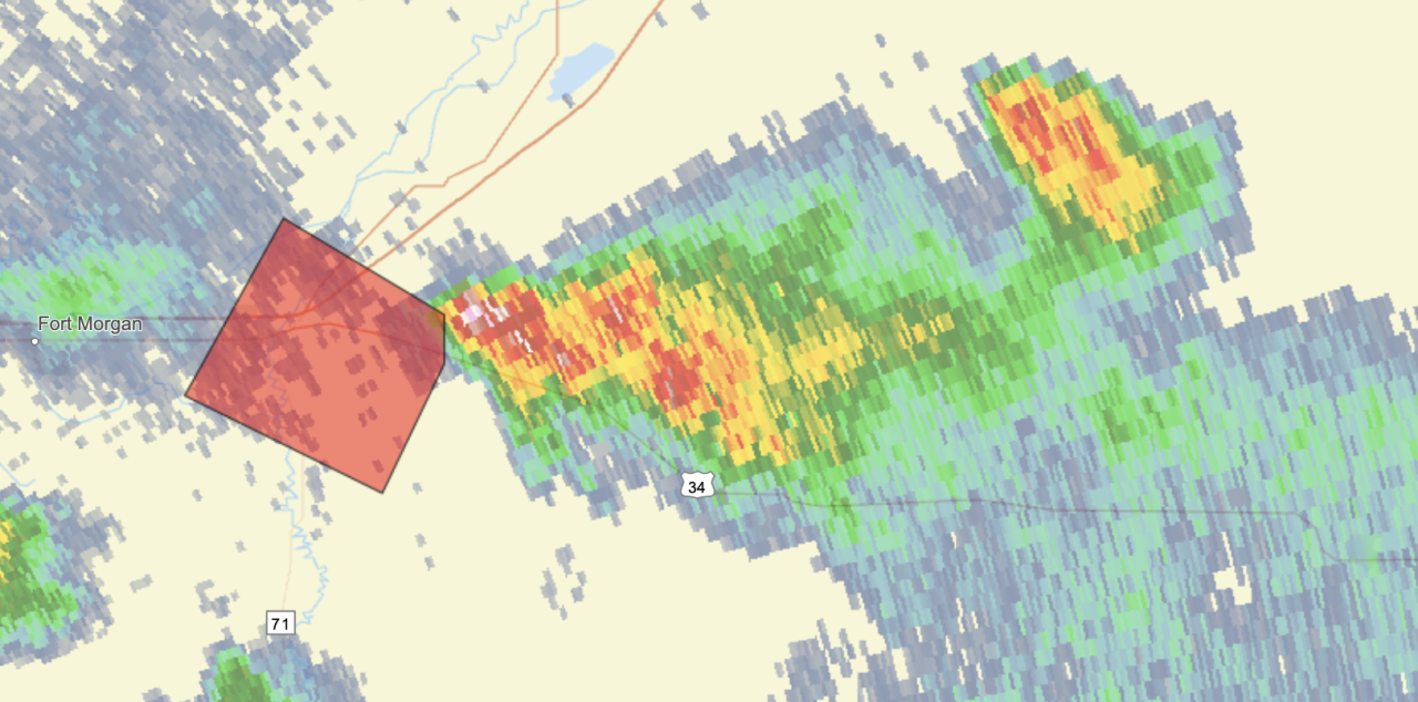
3:51 p.m. | Tornado warning Brush, Colorado | The NWS said in its alert a tornado was observed in the Brush, Colorado area.
Radar image from NWS Boulder:
3:30 p.m. | Severe thunderstorm warning | The NWS has issued a severe thunderstorm warning for a cell 9 miles north of Haxtun for a cell that could produce half dollar-sized hail and wind gusts up to 60 mph. The storm was moving NE at 10 mph, said the NWS.
Portions of East Central Logan, NW Phillips and SW Sedgwick Counties are included in the watch until 4:15 p.m.

1:20 p.m. | Severe thunderstorm watch until 8 p.m. | Several counties in northeastern Colorado, including communities along the edge of the Denver metro, are under a severe thunderstorm watch for the potential of large hail — up to 2 inches in size — and wind gusts up to 75 mph.

12:45 p.m. | Possibility of watch | The Storm Prediction Center said strong winds were a potential concern this afternoon in northeastern Colorado, adding of a possibility of a weather watch at some point today.

Click here to watch the Denver7 live weather stream.