


DENVER — While widespread severe weather is not expected Friday, a few storms could become strong to severe Friday afternoon with the main threat being wind gusts up to 65 mph.
Isolated heavy rain is also possible in some storms, particularly in far northeastern Colorado where a flood watch and severe thunderstorm watch are in effect.
Refresh this page for updates and keep checking back for new details.
LINKS: Latest forecast | Radars | Traffic | Weather Page | 24/7 Weather Stream
Friday, July 11
5:54 p.m. | 2 inch-sized hail possible | Large hail is possible in a line of severe storms from Grover to 8 miles NW of Briggsdale, said the NWS.
A severe thunderstorm warning remains in effect for NE Weld County until 6:45 p.m.
The line is moving SE at 20 mph.

5:47 p.m. | Boulder County severe storm | Half dollar-sized hail is radar indicated in a severe storm near Sunshine in Boulder County.
The cell, 33 miles south of Fort Collins, is moving SE at 10 mph, said the NWS.
The severe thunderstorm warning is in effect until 6:15 p.m.

5:45 p.m. | Yuma County severe storm | Quarter sized-hail and 60 mph wind gusts are possible in a severe storm 9 miles south of Highland Center, which is 19 miles north of Yuma. The storm is moving SE at 15 mph.
The warning is in effect until 6:30 p.m.
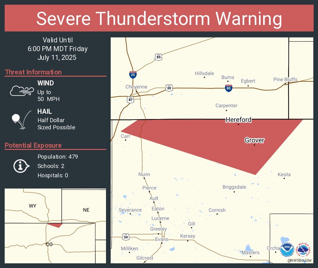
5:34 p.m. | 1 inch hail reported near Rockport | North Central Weld County remains under a severe thunderstorm warning until 6 p.m. for a cell 7 miles SW of Hereford moving east at 25 mph.
A trained spotted reported 1 inch sized-hail and the NWS said up to ping pong-sized hail was possible.
Grover and Hereford are the communities impacted.
5:16 p.m. | Severe t-storm near Hereford | Half dollar-sized hail and 50 mph wind gusts are possible in a storm 9 miles west of Hereford, which is 40 miles north of Greeley, warned the NWS.
North Central Weld County remains under a severe thunderstorm warning until 6 p.m.
The cell is tracking SE at 25 mph.
4:50 p.m. | Ping pong ball-sized hail | The NWS said ping pong ball-sized hail is radar indicated in a severe storm in far NE Larimer County and NW Weld County.
The cell was near Natural Fort moving SE at 25 mph.

4:35 p.m. | Severe thunderstorm watch | Several northeastern Colorado counties are under a severe thunderstorm watch until 11 p.m. Friday.
Large hail up to 2 inches in size and 75 mph wind gusts are the main concern with any severe storms.
Counties in the watch include:
- Larimer
- Logan
- Morgan
- Phillips
- Sedgwick
- Washington
- Weld
- Yuma

4:15 p.m. | Strong storm in Adams, Arapahoe Counties | 40 mph wind gusts and half inch-sized hail are possible in a cell located 7 miles NE of Byers, said the NWS.
The storm is moving east at at 20 mph.
3:30 p.m. | Half inch-sized hail | The NWS is tracking a line of strong storms from Manila Village to Deer Trail in Eastern Arapahoe and SE Adams Counties.
40 mph wind gusts and half inch-sized hail are possible in the are through 4 p.m., said the NWS.
The storms will impact Bennett, Deer Trail, Byers and Strasburg.

3:02 p.m. | Strong storm near Byers | Penny-sized hail and 40 mph wind gusts are possible in a storm 8 miles south of Byers, said the NWS. The cell is moving NE at 10 mph.
2:46 p.m. | Severe thunderstorm watch possible | The NWS Storm Prediction Center said there is a 60% probability a severe t-storm watch will be issued for northeastern Colorado, possibly including the Denver metro.
"Hail and damaging gusts likely this evening," wrote forecasters.

2:30 p.m. | Flood watch starting at 6 p.m. | The NWS warned of possible "excessive rainfall" overnight through Saturday morning for counties in far northeastern Colorado.
"Excessive runoff may result in flooding of rivers, creeks, streams, and other low-lying and flood-prone locations. Extensive street flooding and flooding of creeks and rivers are possible," wrote NWS forecasters

Click here to watch the Denver7 live weather stream.