


DENVER – An arctic blast is sending wind chills plunging to -20 degrees or more in parts of northeastern Colorado as Denver will remain below freezing for days and light snow falls in the metro area, first over the next 24 hours, and again possibly during Broncos game on Sunday.
Denver's wind chills will drop below zero overnight tonight and the actual air temperature will remain below freezing until at least next Monday, triggering Denver to launch its cold weather shelter plan.
Periods of heavier snow are expected on Friday in the High Country where a winter weather advisory is in effect before the Denver metro area sees a better shot at snow later in the evening.

Today's Forecast
Frigid wind chills across E. Colorado, snow overnight in Denver metro
“We’ll have flurries off and on for our Friday and then we’ll have a wave of snow tonight and early Saturday,” said Donaldson. “It looks like we’ll have more accumulation during that time frame than this Friday afternoon.”
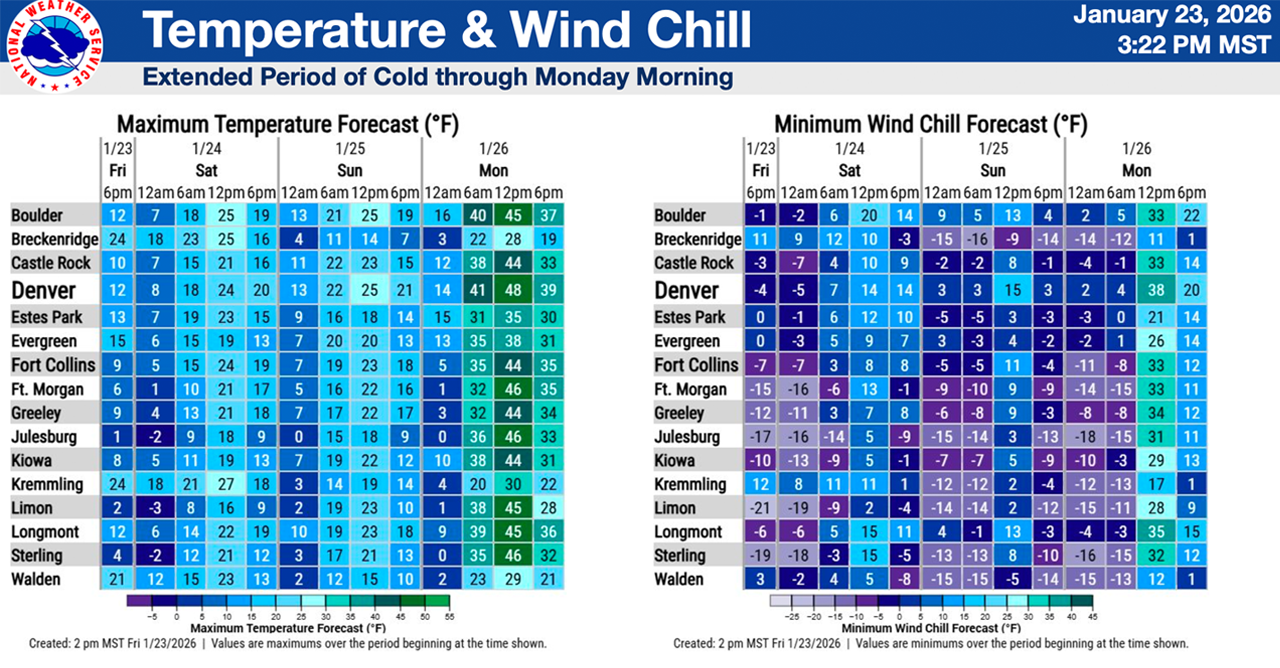
A large portion of Colorado’s northeastern plains remain under a cold weather advisory until Sunday morning for dangerously-low wind chills plunging to 20 or more degrees below zero, “which means frostbite would be possible in less than 30 minutes. Dress warmly in several layers of clothing, including a hat and mittens, and avoid prolonged outdoor exposure,” added NWS forecasters.
By 2 p.m. Friday, the NWS extended the cold weather advisory to include Fort Collins, Greeley and Loveland. Here's the latest alert.

Colorado wind chill forecast
The worst of the wind chills in the Denver metro should happen overnight into Saturday morning where the NWS forecasts the lowest wind chill of around -5 degrees but they will again dip to the single digits over the next 48 hours.
Colorado’s far plains will take the brunt of the brutal cold as wind chills in Limon will make the outside air temperature feel like its -20°, according to the NWS.
“Livestock and pets will be vulnerable to the cold, so ensure adequate sheltering during this extended period of cold weather. Make sure outdoor animals have a warm and dry shelter, food, and unfrozen water,” said the NWS.
In the image below, you can track the latest NWS wind chill forecast through the weekend. It was last updated around 2 p.m. Friday.

The snow will gradually clear through the day on Saturday and motorists should pay extra attention to bridges and overpasses as temperatures remain below freezing for an extended period of time.
“Hazardous travel conditions are expected to impact the Friday evening commute and Saturday AM ski traffic,” said National Weather Service (NWS) forecasters in Boulder, who issued a winter weather advisory until 5 p.m Saturday for the central mountains where between 5 and 11 inches of snow is possible.
Check latest Colorado winter weather alerts
Denver7's Donaldson added, "most lower-elevation spots should pick up around an inch, maybe two inches in a few isolated areas (Friday into Saturday), so we’re not talking about a big snowstorm. It looks like it'll be just enough to slow things down and make roads slick late Friday, early Saturday morning."
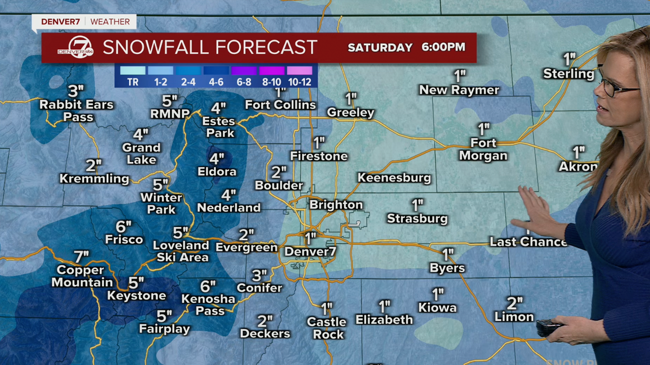
Colorado snow totals
Here are possible “expected” and “high-end” snow totals across Colorado and the Denver metro area from the NWS.
- Allenspark: 5” to 6”
- Arvada: 1” to 3”
- Aurora: 1” to 3”
- Berthoud Pass: 10” to 12”
- Boulder: 2” to 5”
- Breckenridge: 7” to 8”
- Brighton: 1” to 2”
- Broomfield: 1” to 3”
- Castle Rock: 2” to 3”
- Centennial: 1” to 3”
- Commerce City: 1” to 2”
- Denver: 1” to 2”
- DIA: 1” to 2”
- East Portal: 10” to 12”
- Eldora: 6” to 7”
- Fort Collins: 1” to 3”
- Fort Morgan: 1” to 2”
- Georgetown: 4” to 5”
- Golden: 1” to 4”
- Granby: 5” to 6”
- Highlands Ranch: 1” to 3”
- Idaho Springs: 2” to 5”
- Keystone: 8” to 9”
- Lakewood: 1” to 3”
- Larkspur: 2” to 4”
- Limon: 1” to 3”
- Littleton: 1” to 3”
- Longmont: 1” to 3”
- Loveland Pass: 10” to 12”
- Nederland: 4” to 5”
- Parker: 2” to 4”
- Rabbit Ears Pass: 5” to 7”
- Sterling: 1” to 2”
- Vail Pass: 10” to 12”
- Winter Park: 11” to 13”
Here are links to cold weather shelter information and other resources for Denver metro communities.
- Arapahoe County
- Arvada
- Commerce City
- Denver
- Douglas County
- Fort Collins
- Jefferson County
- Littleton
- Lakewood
- Longmont
- Westminster
The City of Denver has activated its cold weather shelter plan.
"All shelter sites are pet-friendly and provide food, showers, and blankets. Transportation will run daily from downtown shelters to cold weather shelter sites. Security will be present at each site, and shelters will deactivate once weather improves," wrote the city in a news release.
Here's additional information from the city on places to find shelter:
- For individual men – Denver Rescue Mission Lawrence Street Community Center, 2222 Lawrence St.
- For individual women – Samaritan House, 2301 Lawrence St.
- For youth/young adults ages 12-24 – Urban Peak, 1630 S. Acoma St.
- For families - Inn at the Highland, 2601 Zuni St. For additional support or questions contact the Connection Center at 303-295-3366.
- 24/7 shelter is being provided at 2601 W. 7th Ave., 375 S. Zuni St., and 4411 Peoria St.
- Additional shelter is now being provided at 4849 Bannock St, and The Aspen shelter at 4040 Quebec St. will open today at 1 p.m.

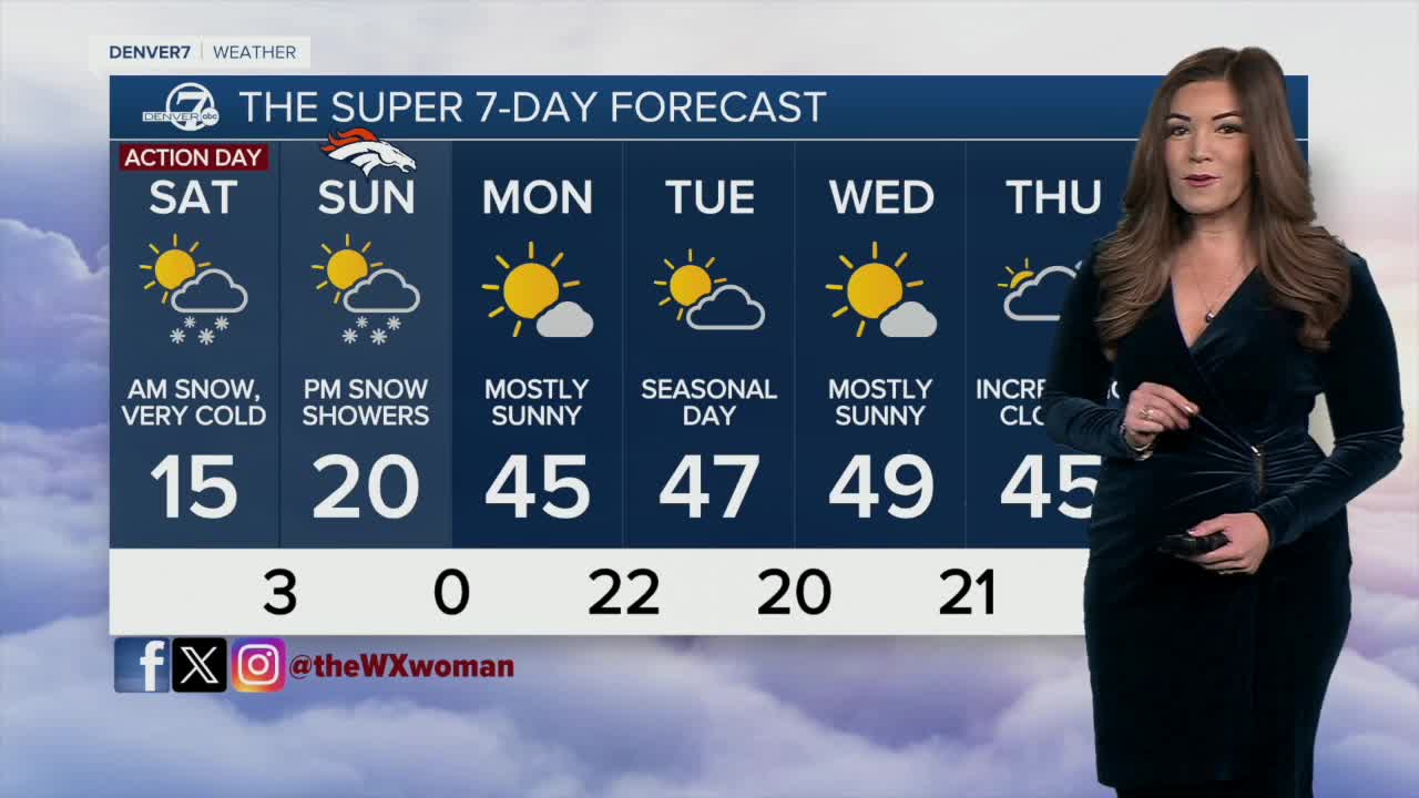
Broncos game day forecast
Denver7 meteorologist Danielle Grant said along with layering up for the really cold temps, if you're headed to Empower Field at Mile High to watch the Broncos take on the Patriots Sunday, you'll also want to prepare for light snow.
"Say it ain't so! I think tailgating it's just going to be cold with a little bit of sunshine," said Denver7 meteorologist Danielle Grant. "Right there around kickoff, the clouds start to push in and we could be looking at low 20s, but not for long. Probably right around the second or third quarter, a little bit of light snow."
Sunday's high in Denver will only reach around 22 degrees and when you factor in the wind chill, temps will feel like around 15 degrees before plunging to the single digits by the end of the game.

DENVER WEATHER LINKS: Hourly forecast | Radars | Traffic | Weather Page | 24/7 Weather Stream
Click here to watch the Denver7 live weather stream.