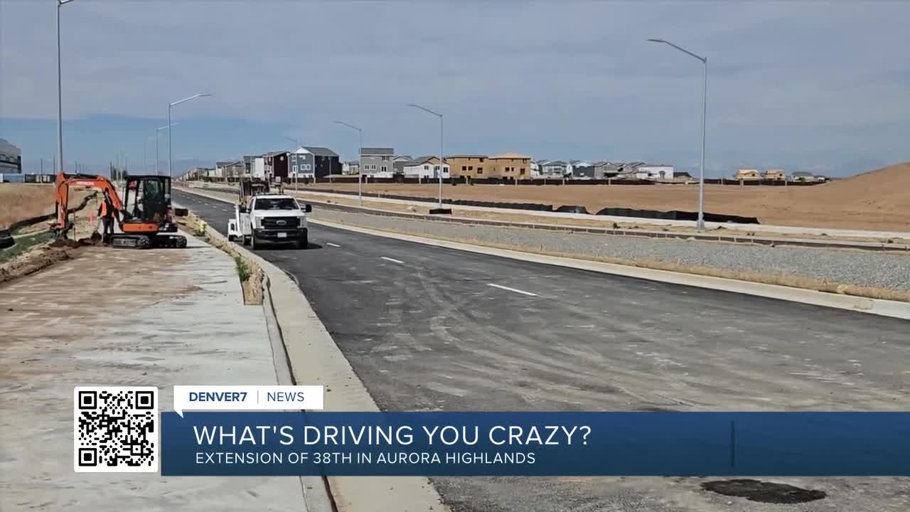


AURORA, Colo. — Jackie from Green Valley Ranch writes, “What's driving you crazy? I work at a school in Aurora Highlands out near DIA. Every day I have to drive south on Piccadilly to E. 26th Ave just to circle back to the Aurora Highlands Parkway. When is E. 38th going to open over the tollway and connect with Aurora Highlands Parkway?”
You are going to have to wait until about Thanksgiving break next school year, Jackie. I’m told it will be about seven months until this connection finally opens. I went out there to take a look last week, walking the 1,000-foot extension of 38th Ave. from Tibet Road to the point the pavement abruptly stops right before a fairly large ravine.
The Aerotropolis Regional Transportation Authority (ARTA) is the entity building this roadway. ARTA governs how the build-out of the roughly 3,000 acres south of Denver International Airport are being developed. I also walked the 400-foot extension of pavement from where the new 38th Ave. bridge crosses over E-470 to that same ravine. The paved sections are beautiful. The pavement was very smooth and I watched as the final street lights were being completed. What was striking to me was the gap between the two road segments. It is about 600 feet long over a drainage area that has a small stream, a water collection area, lots of plains vegetation and a concrete walking/biking trail.
Looking at the Mile High Flood District Map of the area, the ravine is home to First Creek Tributary T and W. Both tributaries meet right here before flowing into First Creek in Green Valley Ranch. This waterway is the significant drainageway flowing from south to north serving as a vital component of Green Valley Ranch East’s natural environment, according to urban planning, civil engineering and landscape architecture company Terricina Design.
“Joining First Creek, this tributary, is a crucial role in the area’s stormwater management solutions. Trib ‘ T’ is a thriving ecosystem, showcasing the importance of preserving and protecting natural habitats within urban environments, ensuring a sustainable future for both humans and wildlife alike,” Terricina Design said
MORE: Read more traffic issues driving people crazy
The delay in bridging this tributary gap for ARTA came down to numerous rejections and revisions of their original flood plain mitigation plan and structure type that was submitted to the Federal Emergency Management Agency (FEMA). The authority was planning on putting in a ConSpan concrete arch bridge system, but is now going to construct a less expensive and less challenging box culvert system that should allow the tributary to flow under the roadway unobstructed and build the roadway over top of that.
During my research of this ravine, I listened to a July 2023 ARTA board meeting where it was stated that the Authority was waiting on the final Conditional Letter of Map Revision (CLOMR) approval from FEMA for this First Creek Tributary T crossing. A CLOMR is a decision from FEMA stating whether a proposed project, if built as designed, will meet National Flood Insurance Program (NFIP) standards. It is a necessary document requested before construction to ensure a project will not negatively affect flood hazards and is a required step for projects encroaching on floodplains.
ARTA stated in that same meeting that numerous businesses and nearby developers were anxiously anticipating quick completion of this connection to E470. Unfortunately, when ARTA heard back from FEMA, the comments they received were “substantial,” requiring them to submit a new CLOMR for consideration. At the ARTA November 2023 board meeting, it was announced that FEMA commented back with another rejection of their revised flood control plan. What happened, according to the meeting, was FEMA did not approve the ARTA plan mainly based on physical changes within this floodplain that would affect the hydrologic or hydraulic characteristics of the flooding source. The consultant for ARTA, working on this plan at the time, was told by FEMA to modify modeling to match the updated flow conditions even though — as the ARTA meeting notes outlined — this concern was vetted prior to submission with City of Aurora, Mile High Flood District and FEMA’s hydraulic consultants.
Another modified plan was submitted to FEMA in January 2024. That too was rejected and yet another CLOMR was submitted to FEMA in May 2024. That was the one that was finally approved. With that approval, the process of hiring a contractor commenced. The board selected the construction company HEI to complete this final part of construction, although it wasn’t until spring 2025 that the roadway extension work began. That work was just completed this spring.
I talked to a someone who did some early work on this project and I was told the numerous rejections from FEMA were “miserable” but also an important part of the process needed to get through before starting any work.
I reached out to the ARTA for a status update. ARTA’s program manager David Center told me they are very pleased that construction on the placement of the box culverts will start this week. “
All documents are approved and they are ready to move to construction,” Center said.
Construction will include placing two box culverts instead of the original ConSpan bridge structure that will allow water from Tributaries T and W to flow north. A separate box culvert will be installed for pedestrian use just like one that is already in place to the north along the concrete walking trail. Center told me while all the revisions requested by FEMA and the eventual change of structure type added time to this part of the project, the change will be more cost efficient and pedestrian friendly than the ConSpan, a bridge or any other structure they could have used.
The work schedule has construction starting this week with the expectation of completion and the road open by early November. I’m told that timeline could change depending on weather or other unforeseen factors.
When I asked Center if he was excited to see the final part of this project move forward, he told me, “Everyone is excited to have it open.”
Denver7 Traffic Expert Jayson Luber says he has been covering Denver-metro traffic since Ben-Hur was driving a chariot. (We believe the actual number is over 25 years.) He's obsessed with letting viewers know what's happening on their drive and the best way to avoid the problems that spring up. Follow him on Facebook, Twitter or Instagram or listen to his award winning Driving You Crazy podcast on any podcast app including iTunes, iHeartRadio, Spotify, Podbean, or YouTube.
WHAT'S DRIVING YOU CRAZY? DENVER7'S JAYSON LUBER ANSWERS YOUR QUESTIONS.
-
When are they going to fix the bumps on I-76 from Julesburg to Sterling?
-
Someone should probably look into the crumbling Manilla Road, I-70 overpass
-
Why are DIA's close-in parking lot accessible spaces roped off?
-

Why are you allowed to use the crosswalk on only one side of 120th and Chase?
-

Driving You Crazy: The roundabouts on Lowry Boulevard make no sense


