


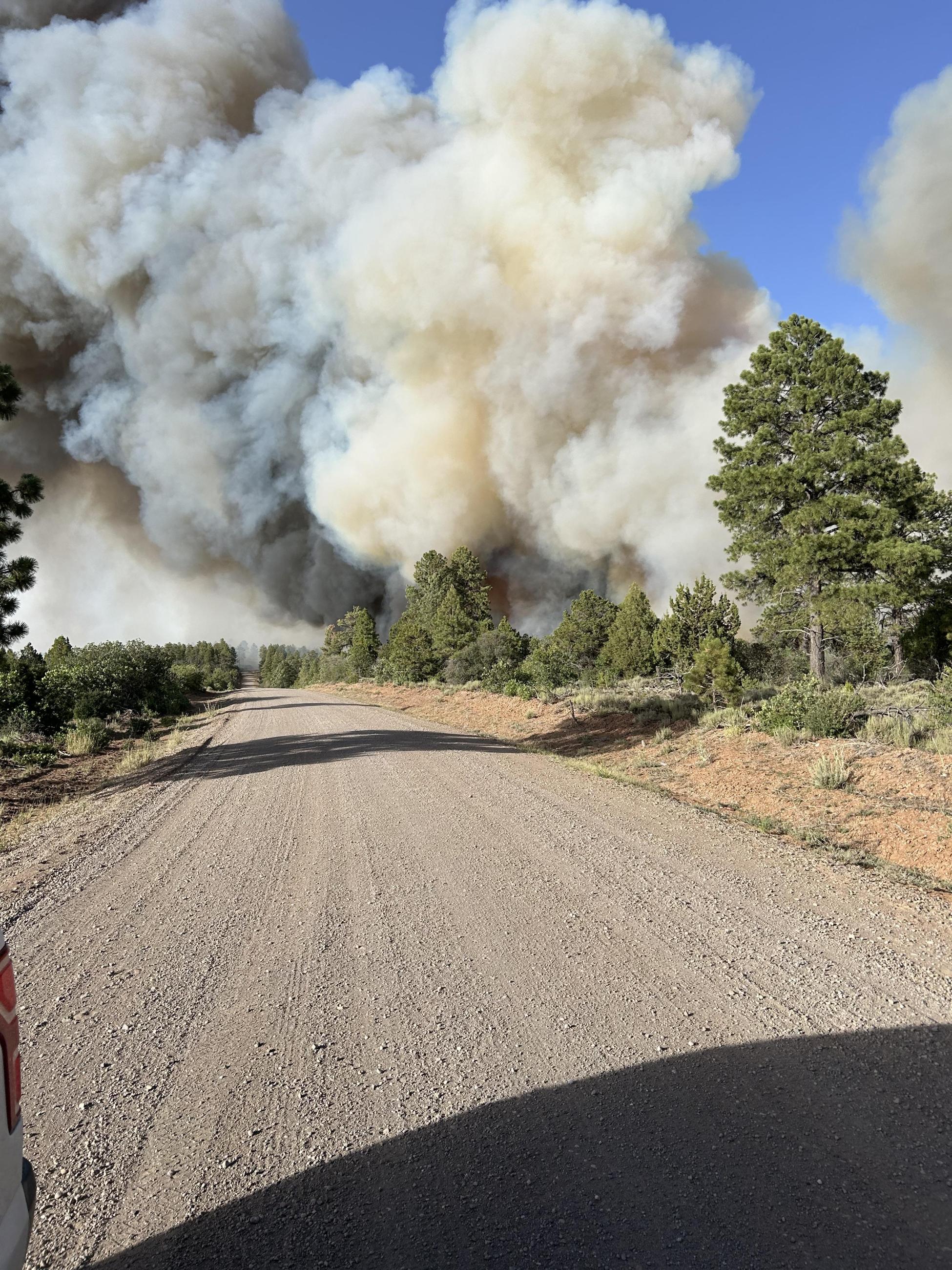
The 50,000-acre Aspen Acres Fire remains 0% contained and has destroyed more than 180 structures in southern Colorado this week.
Denver7 is covering this wildfire, as well as the others that continue to burn around Colorado's mountain and Western Slope.
WATCH: Colorado Gov. Jared Polis is set to speak about the wildfires in Colorado shortly.
We covered these wildfires in-depth each day this week: Here are our stories from Monday, Tuesday and Wednesday.
Below are the latest details on each of the wildfires.
All of the below information on Colorado's wildfires will be updated as we learn more. All fire perimeter maps below are courtesy of Watch Duty.
Aspen Acres Fire
- 📍Custer and Pueblo counties
- Size: 50,186 acres (as of Thursday, 11:15 a.m.)
- Containment: 0% (as of Thursday, 11:15 a.m.)
- Start date: June 29
- Cause: Human, under investigation
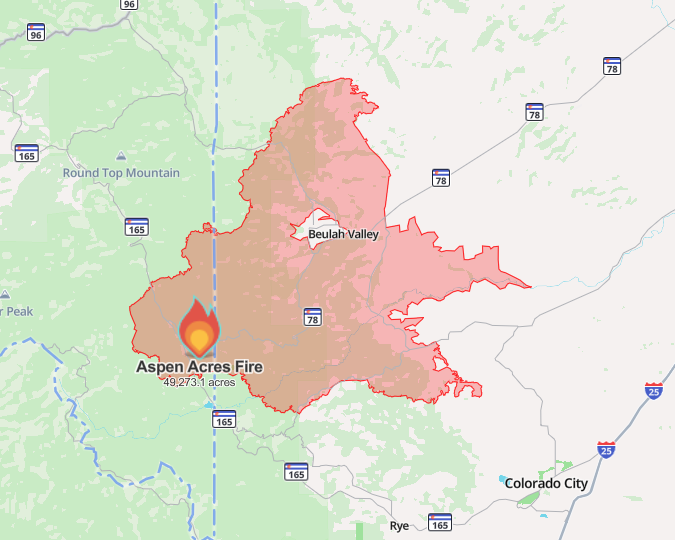
The Aspen Acres Fire, burning in Custer and Pueblo counties about 15 miles northwest of Colorado City, is the largest wildfire currently burning in Colorado.
The sheriffs of the two counties confirmed the fire has destroyed about 180 structures — 125 in Pueblo County and 55 in Custer County. Residents who were evacuated are not yet allowed back to their homes to assess the damage.

One firefighter was injured in Custer County on Monday, the sheriff's office said.
EVACUATIONS AND CLOSURES | The following areas remained under an evacuation order, as of Thursday morning:
Mandatory evacuations:
- Lazy Acres
- Bishops Castle
- 12 Mile Road
- S. Pines Drive
- San Isabel
- Rye
- Beulah (including 12-mile, North Creek, S. Pine Drive, Beulah proper and east to Waterbarrel Road)
- 3R Road to Crow cutoff
- 3R Road east to Water Barrel Road
- Burn Mill Road to I-25
- Crow Cutoff west to Boulder Avenue
- Red Creek Ranch area, north of Highway 78, south of Highway 96, and west of Siloam Road
- Wetmore, and north of the town to the county line, as well as from the Pueblo County line to McKenzie Junction (includes Highway 96 in this area)
- Colorado City north of 165, west of Crow Cutoff to Table
- Red Creek Area from Siloam Road East to the area of Red Creek Springs Road West and Highway 96 West
- Pre-evacuations:
- Southern Fremont County, including properties along Highway 67
An evacuation center, disaster assistance center and livestock evacuation center are set up. Here's a breakdown of what each can provide.
Incident Commander Philip Daniels explained on Wednesday that it will be several days before evacuees are allowed back to their homes.
Highway 165, Highway 78, and Highway 96 are closed in this area. Highway 78 is closed between Highway 165 and Rock Creek Road, and Highway 67 is closed between Wetmore and milepoint 3.

The historic Horseshoe Lodge in Pueblo Mountain Park sustained significant damage, Pueblo County Sheriff David Lucero said.
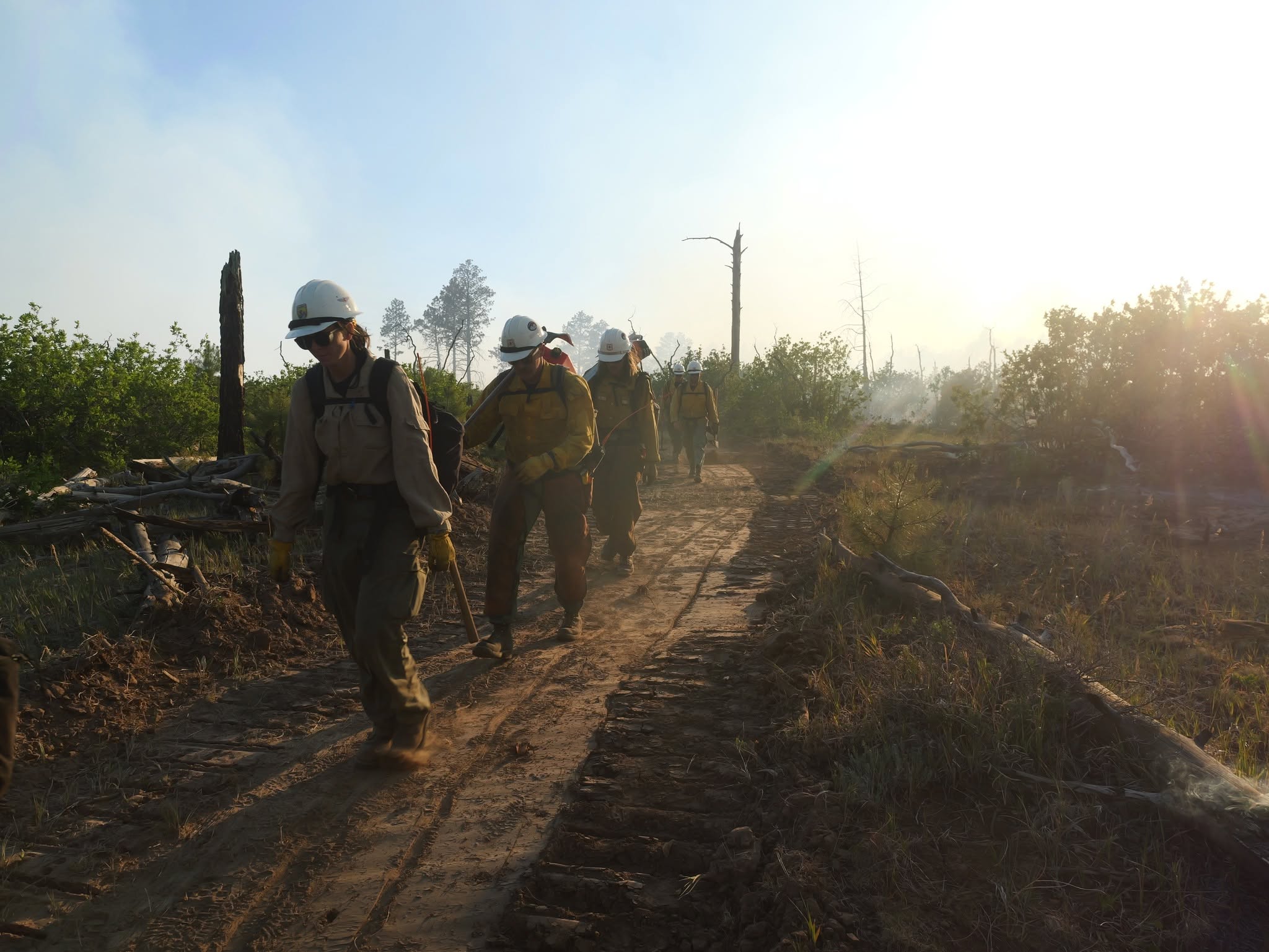
THURSDAY UPDATES | More firefighters will arrive on Thursday, ahead of another day of extreme fire behavior expected, the incident management team said. The fire may spot up to a mile ahead of the front at times, the team said.
A red flag warning is in effect from 10 a.m. to midnight Thursday. A dedicated incident meteorologist will arrive on Thursday.
Colorado Gov. Jared Polis will visit Pueblo County on Thursday to meet with Coloradans impacted by the Aspen Acres Fire and thank first responders and volunteers.

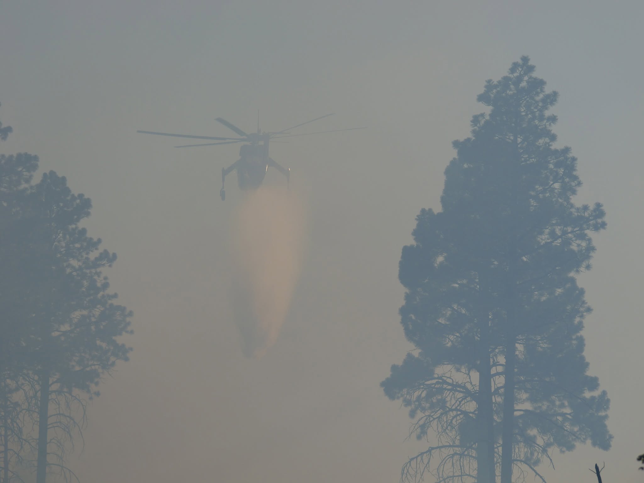
SUMMARY OF FIRE HISTORY | The Aspen Acres Fire had "significant activity" Wednesday afternoon and spread farther west into forests and east toward Siloam Road. The southeast part of the fire saw "extreme fire behavior," according to the incident command team. Several large and very large airtankers flew over the fire on Wednesday.
Gov. Polis verbally declared a disaster emergency for this fire on June 29. Later that day, FEMA authorized the use of federal funds to help with firefighting costs for this fire.
Ferris Fire (includes Far Draw Fire & Doe Canyon Fire)
- 📍Montezuma and Dolores counties
- Size: 27,382 acres (as of Thursday, 10 a.m.)
- Containment: 0% (as of Thursday, 10 a.m.)
- Cause: Lightning

The Ferris Fire began burning in far northern Montezuma County before making a massive run north into Dolores County, growing to reach almost halfway through the county.
The fire is expected to reach the Dolores River to the west on Thursday and crews are prepared to try to prevent the fire from jumping and expanding on the opposite shore.
Crews on the ground have the assistance of aircraft on Thursday morning, but the incident management team said they are preparing for the sixth straight day of red flag weather conditions. While winds are expected to gradually decrease over the next few days, temperatures will rise. A "super scooper" aircraft from Alaska is expected to arrive Thursday and may start pulling water from the McPhee Reservoir on Friday.

EVACUATIONS AND CLOSURES | Evacuations have been in place since Saturday for this wildfire. Several new ones have been added since. Here is the latest on evacuations for the Ferris Fire:
- Mandatory evacuations
- Lone Dome Road
- Bradfield Campground
- Campground down Highway 504 to the McPhee Dam
- Glade Ranch subdivision
- "Set" status/evacuation warning
- Dolores River Canyon to Road 15
- From Road P on the south to Road H.6 on the north
Anybody who evacuated is welcome to come to the Pleasant View Fire Station at 15235 Road CC.
THURSDAY UPDATES | Firefighters on the northwest side of the Ferris Fire are identifying roads and natural barriers to create indirect fireline. They do not expect the fire to make a big run to the north on Thursday, according to the incident management team.
A hotshot crew will join the effort on Thursday along the fire's northeast corner near Benchmark Lookout. Firefighters are already constructing fireline here to stop the fire's spread toward the Glade Ranch subdivision, which has already been evacuated.
Multiple aircraft will work around the blaze Thursday, including three heavy and one light helicopter, large air tankers and single-engine airtankers.
A community meeting is planned Friday at 6 p.m. at the Dove Creek Public Service Center, located at 8477 Road 7.7 in Dove Creek.
SUMMARY OF FIRE HISTORY | The Ferris Fire began burning near Narraguinnep Canyon, about 15 miles northwest of Dolores, on June 27. The nearby Doe Canyon Fire and Far Draw Fire merged with the Ferris Fire, so the blaze is now being managed as the Ferris Fire.
Crews have been prioritizing the northeast corner of the fire, which is closest to private land, according to the official Ferris Fire Facebook page.
On Wednesday, the fire backed down Doe Canyon and other nearby canyons leading to the Dolores River
Dolores Volunteer Fire & Rescue has responded to this fire and is accepting donations.
Stage 2 fire restrictions went into place for the San Juan National Forest on Wednesday, prohibiting all campfires.
Gold Mountain Fire
- 📍Ouray County
- Size: 18,005 acres (as of Thursday, 10 a.m.)
- Containment: 0% (as of Thursday, 10 a.m.)
- Start date: June 27
- Cause: Unknown; possibly a tree fell on a power line
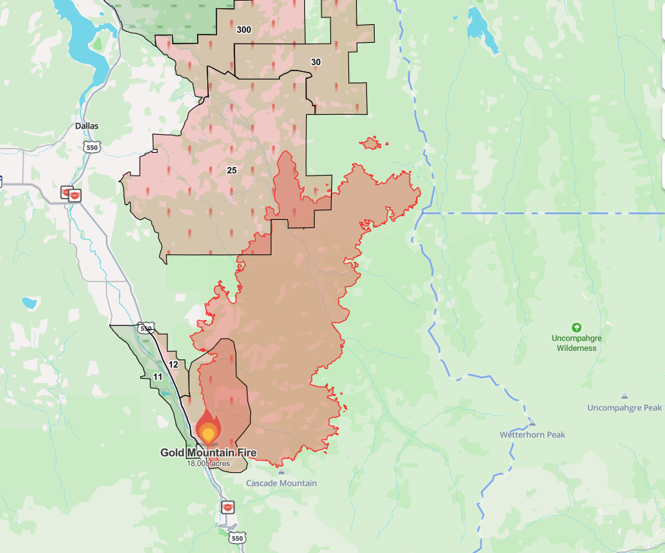
The Gold Mountain Fire burning in Ouray continues to inch its way farther north and northeast toward the far southwest corner of Gunnison County, which has issued an evacuation warning.
On top of already-dangerous conditions, firefighters have faced the challenge of steep terrain around this wildfire. The incident command team said Thursday that the crews had been successful keeping the fire away from values at risk along the US 550 corridor.
A red flag warning is in effect from noon to 8 p.m. Thursday in this area.
EVACUATIONS AND CLOSURES | Evacuations have been in place since Sunday. Here's the latest:
Mandatory evacuations:
- Lake Lenore and Panoramic Heights areas
- Redstone Road
- Peck’s Trailer Park
- Cedar Hill Cemetery, east of US 550
- Anybody recreating in the area of Cow Creek on U.S. Forest Service land past the intersection of County Road 12
- Lower Cow Creek, east of County Road 12 and County Road 12A to the Owl Creek U.S. Forest Service boundary
- Pre-evacuations:
- Ouray County: From Whispering Pines to Black Lake neighborhood along County Road 17
- Ouray County: East of US 550 from County Road 8A north to County Road 4 and east to Cimarron Ridge and the USFS boundary
- Gunnison County: Area just north of Hampton Lake and Fish Creek Reservoir
- Gunnison County: East of County Road 864A and west of Big Blue Creek, up to the Bureau of Land Management boundary
- Gunnison County: South of the intersection of County Road 883 and County Road 864
- Montrose County: Area south of the P77 Road/Cimarron Road intersection and any properties on P77 Road one mile north of that intersection
Click here for an interactive map of all current evacuations. An evacuation center has been set up at the Ridgway Secondary School, located at 1200 Green St. in Ridgway.
Colorado Parks and Wildlife has closed public access to the Cimarron State Wildlife Area in Montrose County due to this fire.
THURSDAY UPDATES | Firefighters are continuing to reinforce the existing fireline north of Ouray and east of US 550 to prevent the flames from spreading to the south. This has been a successful effort so far, the incident management team said Thursday morning. Crews on the west side and north side are looking for ways to connect and build fireline, but the terrain in these areas is steep and treacherous and not always safe for firefighters to work in.
Fire behavior may increase headed into the later afternoon, the management team reported. The Ouray County Emergency Management group warned drivers to be careful on US 550 and Highway 62, as the fire may be distracting.
A red flag warning will expire at 8 p.m. Thursday.
SUMMARY OF FIRE HISTORY | Ouray County declared a state of emergency on Sunday, June 28 for this fire, which originated on U.S. Forest Service land two miles northeast of the City of Ouray.
The fire pushed east across the Cow Creek drainage and up Stealey Mountain on Tuesday, as it also made a run northeast toward Owl Creek Pass, according to an incident management team.
US 550 north of Ouray was closed for some time, but reopened on Wednesday at 1 p.m. However, drivers should be prepared for emergency road enclosures at any time. Stopping or standing on the highway in this area is not permitted.
The Ouray Volunteer Fire Department is responding to this fire and is accepting donations here. The Ouray County's emergency response team reports there is an immediate need for drinks, including bottled water, sodas, sports drinks and other non-alcoholic beverages. Here's how to help.
Colorado Gov. Jared Polis verbally declared a disaster emergency in response to the Gold Mountain Fire on Sunday.
Willow Fire
- 📍Lake County, west of Leadville
- Size: 2,207 acres (as of Thursday, 10 a.m.)
- Containment: 0% (as of Thursday, 10 a.m.)
- Start date: June 28
- Cause: Unknown
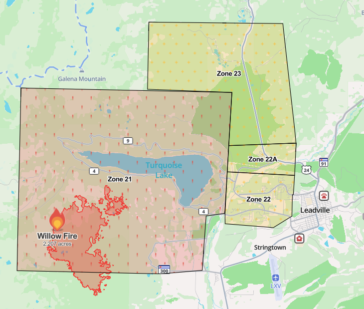
The Willow Fire is slowly growing southwest of Turquoise Lake and west of the City of Leadville. While the area around the lake is under evacuation orders, Leadville proper remains under an evacuation warning.
A community meeting is planned for Thursday at 6 p.m. at the Lake County High School auditorium, located at 1000 W. Fourth St. in Leadville.
Fire officials said "a full suppression strategy remains underway" for this fire. No structures have been lost and nobody has been injured in this fire.
EVACUATIONS AND CLOSURES | An interactive map of current evacuations is here. Here is a breakdown of the ones in place:
- Mandatory evacuations are in place for:
- County Roads 4, 9, 9D, 5A, 48, and 99
- All trails from the Fish Hatchery
- All campgrounds around Turquoise Lake
- All trails up to treeline and Colorado Trail sections in this area (search and rescue teams helped with this effort)
- Hagerman Pass
- Pre-evacuation orders:
- Homes in the Grand West area, Mountain View East and West, Turquoise Lake Estates, Silver Hills Subdivision
- Homes on County Roads 9, 17, and 4
- Northeast Leadville
An evacuation center is located at the Colorado Mountain College Leadville campus.
Half Moon Road and its camping areas are also closed as a precaution ahead of the holiday weekend.
Multiple roads are closed in the area for first responders, including Turquoise Lake Road, Highway 300 at County Road 5 and County 5A (Fish Hatchery Loop), County Road 9 and County Road 99 intersection (Leadville Junction), and County Road 4 and County Road 48 (Turquoise Lake Dam entrance).
THURSDAY UPDATES | Firefighters are working to connect potential containment lines around the northwest side of the fire as they continue to strengthen structure protection around Turquoise Lake, according to the incident management team. Aircraft will help support ground operations and weather conditions allow Thursday.
A few spot fires on the north side of the fire merged on Tuesday and crews are working to contain this as well.
A red flag warning is in effect Thursday and a fire weather watch will likely go into place Friday.

SUMMARY OF FIRE HISTORY | On Sunday afternoon, the Lake County Office of Emergency Management announced evacuations for the Willow Fire, which is burning on U.S. Forest Service land south of Turquoise Lake and west of the City of Leadville. It is about two miles northwest of the Leadville National Fish Hatchery.
Denver7 reached out to the the U.S. Fish and Wildlife Service on Wednesday to hear how hatchery staff is protecting the fish in its care. Their full statement is below:
"The U.S. Fish and Wildlife Service, in partnership with Colorado Parks and Wildlife, mobilized an evacuation effort to relocate greenback cutthroat trout and Hayden Creek cutthroat trout from the Leadville National Fish Hatchery due to the nearby Willow Fire. The fish were safely transported to one of three Colorado state-owned hatcheries: Roaring Judy, Durango, and Mt. Shavano. Because of their unique genetic significance, the fish were housed in isolated facilities at each hatchery to protect them from potential disease exposure and prevent genetic mixing with other populations.
We will continue to work closely with our state partners to help ensure the safety of personnel while safeguarding these important native trout for future conservation efforts."
Colorado Gov. Jared Polis verbally declared a disaster emergency for this fire on Monday morning. Sign up for emergency alerts here.
Snyder Fire/Snyder Mesa Fire
- 📍Mesa County on Colorado-Utah border
- Size: 30,193 acres (as of Thursday, 10 a.m.)
- Containment: 49% (as of Thursday, 10 a.m.)
- Start date: June 26
- Cause: Lightning
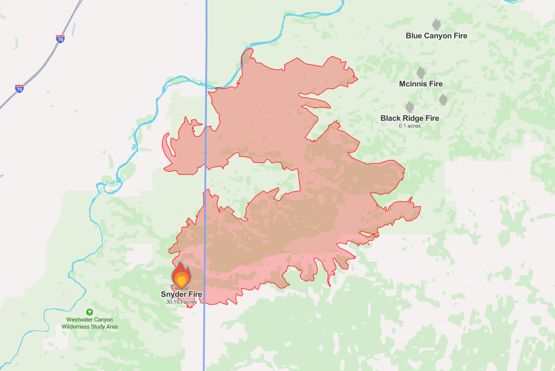
Growth at the Snyder Fire on the Colorado-Utah line has been minimal, despite critical fire conditions this week. Firefighters were able to increase containment to 49% by Wednesday evening, and most of this containment is along the northeastern edge, as well as the southwestern corner.
"In the absence of flare-ups, little to no fire growth is anticipated," the incident management team said Thursday.
Three firefighters died fighting this fire during a burnover incident on Saturday. They have been identified as Emily Barker, 38, Nick Hutcherson, 27, and Sydney Watson, 27.

Wildfire
Family grieves 'brave' and 'kind' firefighter killed in Snyder Fire
EVACUATIONS AND CLOSURES | No evacuations are in place.
Road closures remain on A 2/10 Road at DS Road in Glade Park and BS Road at 11 5/10 Road in Glade Park, according to the Mesa County Sheriff's Office.
Emergency closures are in place along the Colorado River downstream of Fruita until the Utah state line. An operations section chief said Tuesday that they had to rescue almost 120 people over the weekend from the area. Anybody floating the Colorado River must end their trip at the Fruita boat ramp, as there are no river takeout points between Fruita and the Utah state line, officials said.
This closure is expected to last through the Fourth of July weekend.

Wildfire
120 people, 6 dogs, 1 cat rescued as Snyder Fire approached Colorado River
THURSDAY UPDATES | More resources will arrive Thursday to help on the southeastern side of the Snyder Fire.
A community meeting is planned at the Glade Park Community Center on Thursday at 6 p.m. This will be livestreamed on the Snyder Fire 2026 Facebook page.
SUMMARY OF FIRE HISTORY | Firefighters were able to gain some containment at the Snyder Fire burning in Mesa County on the Utah-Colorado line on Tuesday evening as activity was "relatively low," according to the incident management team.
That containment increased to nearly 50% on Wednesday evening.
The Upper Colorado River Interagency Fire Management Unit reported that lightning started this fire.
Gov. Polis verbally declared a disaster emergency in response to this fire on Saturday, June 27.
Big Sheep Fire
- 📍 Huerfano County
- Size: 1,152 acres (as of Thursday, 11 a.m.)
- Containment: 50% (as of Thursday, 11 a.m.)
- Start date: June 29
- Cause: Unknown

The Big Sheep Fire, also called Sheep Head Fire, in Huerfano County increased slightly overnight to 1,153 acres but containment has stayed at 50% since Tuesday evening.
It is burning west of Big Sheep Mountain and north of La Veta Pass in Huerfano County. It started on Monday.
EVACUATIONS AND CLOSURES | The Huerfano County Sheriff's Office said Monday evening that the area "between the fire and Highway 69 and to Farisita" is under a pre-evacuation notice as a precaution. These orders remain in place Thursday.
THURSDAY UPDATES | A Colorado State Incident Management Team will take over operations Thursday.
SUMMARY OF FIRE HISTORY | The Big Sheep Fire is burning west of Big Sheep Mountain and north of La Veta Pass in Huerfano County.
It started on Monday. Evacuations were briefly ordered on June 29 before they were downgraded to pre-evacuation status.
Click here to sign up for alerts for this fire.
Editor's Note: The Dry Creek Fire and 11 Fire are both 100% contained and therefore not on this list anymore.