Wildfires continue to burn around Colorado's Western Slope but containment has increased for several of them as firefighters continue to strengthen the lines around each blaze.
The forecast looks hot and dry in western Colorado this week, so Denver7 will keep an eye on fire updates and bring you the latest on any changes to size, containment and evacuations.
Earlier this month, Colorado Gov. Jared Polis issued a disaster declaration for the fires.
- See all of Denver7's wildfire coverage here
South Rim Fire
Location: Black Canyon of the Gunnison National Park in Montrose County
Start date: July 10
Size: 4,232 acres
Containment: 41%
Cause: Lightning
Latest update: The south rim of the Black Canyon of the Gunnison National Park is still closed as firefighters continue their work on the South Rim Fire.
The National Park Service (NPS) announced on Sunday that the north rim of the canyon will reopen to the public on Wednesday. Visitors will once again be able to access trails, overlooks and the North Rim Campground, which is open on a first come, first-served basis. If they have any questions, park staff will be available from 10 a.m.-3 p.m. each day.

The South Rim Fire was one of three wildfires that were ignited on July 10 after dry lightning early in the morning struck in the national park. The other two are the Warner Fire, which has been suppressed by the Bureau of Land Management, and the North Rim Fire.
The park superintendent declared an emergency park closure and all visitors were evacuated. The NPS said nobody was injured or killed during the evacuation. The park officially closed on July 11.
The South Rim Fire went on to destroy multiple structures in the park, including a maintenance building, a welding shop, storage buildings, campgrounds and vault toilets. No private homes or buildings have been lost.
Aerial firefighting resources used Blue Mesa Reservoir to help put out the flames.
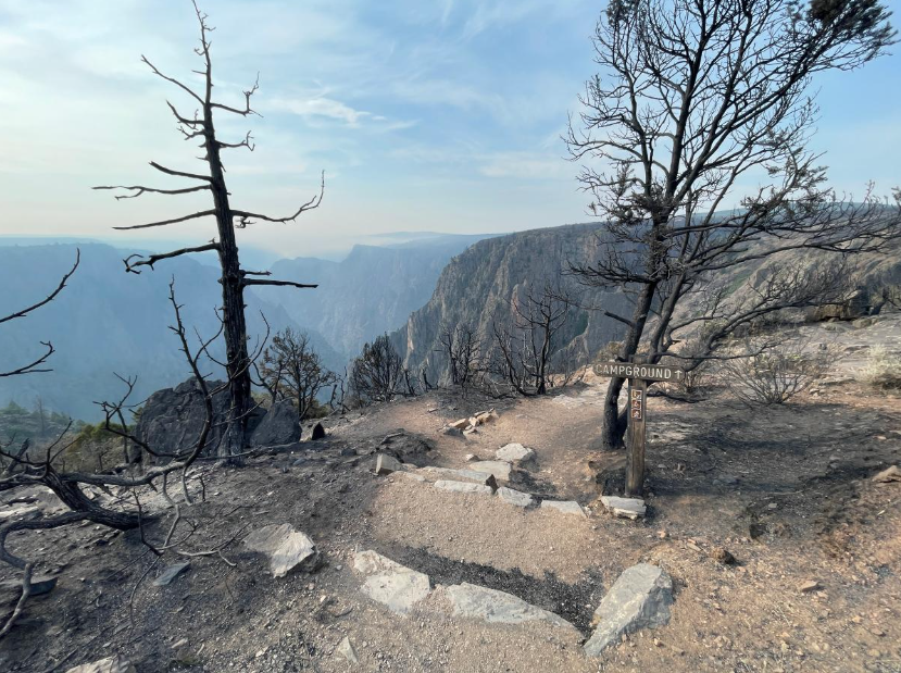
The canyon has vertical cliffs, which made fire suppression difficult, along with the fact that the national park is full of highly flammable pinyon-juniper forest, officials said.
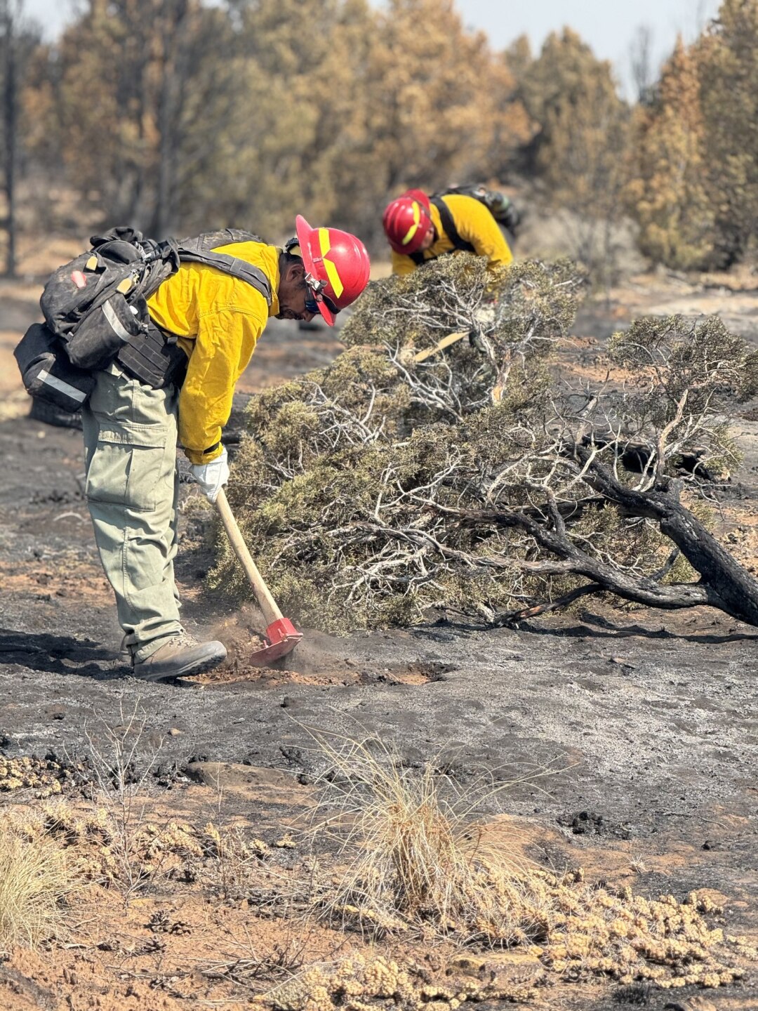
On Monday, Denver7's Anusha Roy spoke with David Vitwar. one of the firefighters on the front lines of this fire. He described the difficult terrain around the fire and the challenges they have overcome. Hear from Vitwar in the video below.
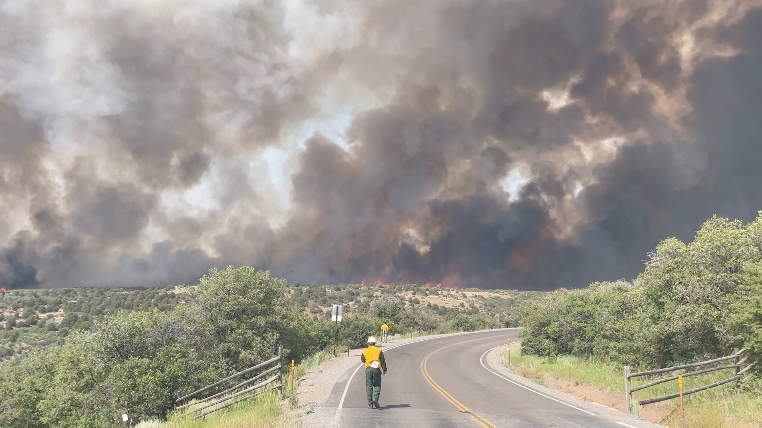
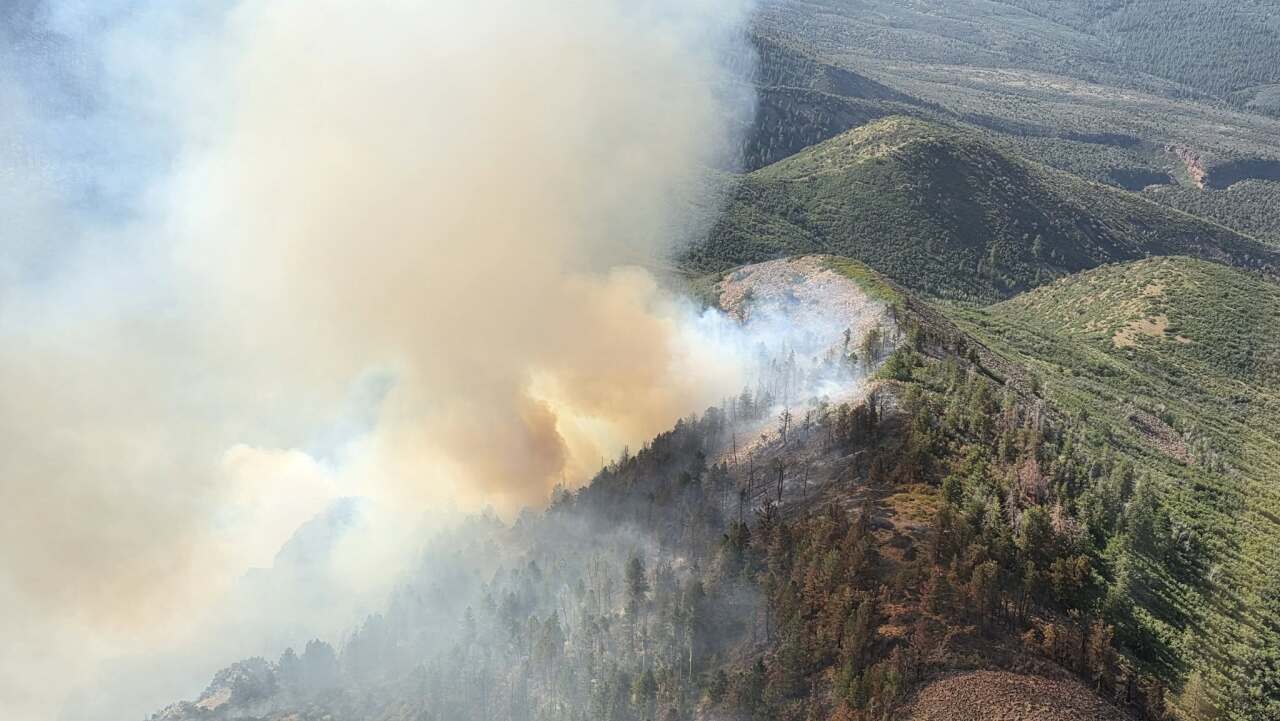
Turner Gulch Fire
Location: Eight miles northeast of Gateway
Start date: July 10
Size: 20,044 acres
Containment: 54%
Cause: Lightning
Latest update: Fire personnel are continuing to work on Tuesday to fully suppress this fire. The southwest side of the fire, where terrain is steep and treacherous, continues to be the most active. Fire officials said it is too dangerous to put firefighters on the ground here, so they are relying on firefighting aircraft.
Hot and dry conditions are expected on Tuesday. Wind gusts up to 20 mph are possible, and will become more erratic if thunderstorms build in the afternoon.
As of noon on July 27, all evacuation alerts have been downgraded to pre-evacuations. This included private lands in the Big Creek and Divide Forks Campground, the Uncompahgre National Forest from Forest Road 406 to 409, and the Ute Creek Evacuation area. View the evacuation map here.

The 466-acre Wright Draw Fire broke out in this same area. As of July 27, fire officials said they had seen no residual heat using infrared equipment around the burned area. No future updates are expected on this fire.
Rim Road Fire
Location: Southern Ute Indian Reservation
Start date: July 26
Size: 114 acres
Containment: 25%
Cause: Under investigation
Latest updates: Firefighters continue to make progress at the Rim Road Fire and reported no new growth on Sunday. The fire is burning in timber and brush as crews work to strengthen the containment lines.
All evacuation notices were lifted at 1 p.m. Monday.
Sowbelly Fire
Location: Dominguez-Escalante National Conservation Area (about 15 miles west of Delta)
Start date: July 10
Size: 2,274 acres
Containment: 95%
Cause: Lightning
Latest update: The management team for this fire posted a final update on July 25, saying fire and medical support personnel were pulled from the area as "minimal heat remains." Patrols remained around the burn area for a few days to monitor for any new fire activity.
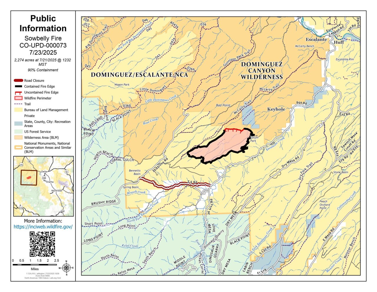
First responders used hand line instead of dozers to try to limit the long-term impact on the ecosystem while also suppressing the fire.
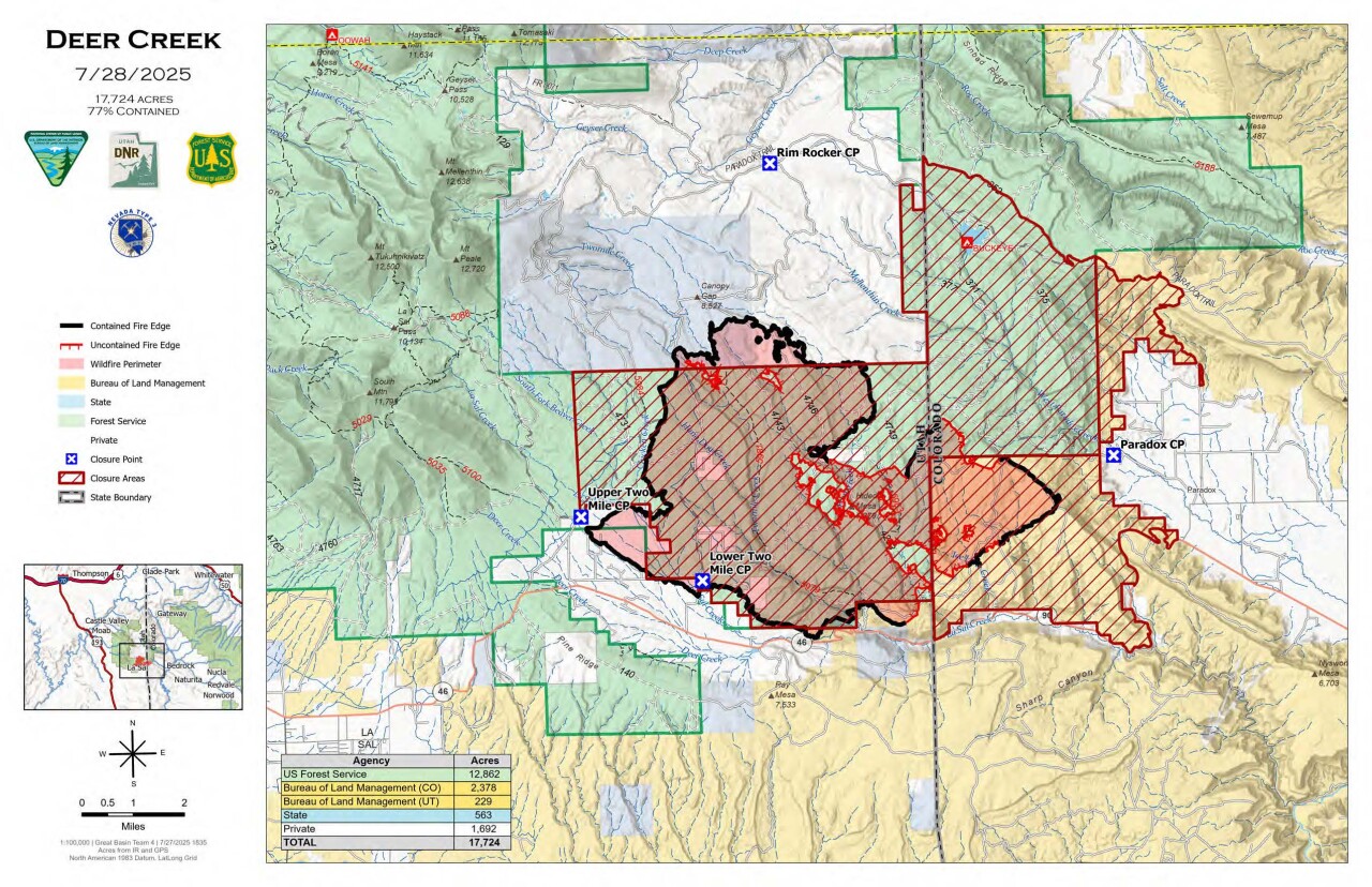
Deer Creek Fire (Utah and Colorado)
Location: Started in La Sal in San Juan County, Utah and has moved east into Colorado
Start date: July 10
Size: 17,724 acres
Containment: 77%
Cause: Under investigation
Latest update: The Deer Creek Fire, which started in Utah and then burned across the state line, has remained stable in the past 24 hours. Hot show crews arrived on Sunday and are working "on the interior islands of patchy fuels to assist and support the continued air attack operations," according to Utah Fire Info.
Evacuations and pre-evacuation orders are in effect for Utah residents.