


The threat of flooding remains through at least midday Friday in the Denver metro and northeastern plains as a storm continues to bring heavy precipitation to Colorado.
Showers and storms, plus excessive runoff may result in the flooding of rivers, creeks and low-lying, flood-prone areas. Burn scars will also be susceptible to flash flooding. We could see another 0.5 1 to 1 inch of rain through Friday. A flash flood watch that covered the Denver metro, surrounding areas and the northeastern Colorado plains expired, but localized flood warnings remain in effect.
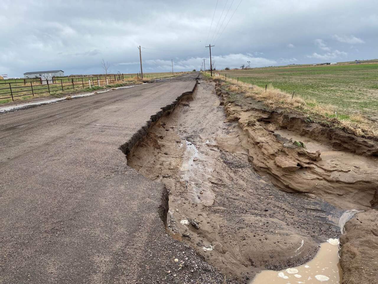
Friday, AirTracker7 surveyed flooding conditions across the region and you can view the raw footage in the player below.
LEARN MORE: Hourly forecast | Radars | Traffic | Weather Page
FRIDAY, MAY 12
3:43 p.m. | AURORA ROADS REOPEN | All lanes are back open at Alameda and Havana in Aurora after floodwaters took down the lights at the intersection last night. 6th and Powhattan is still closed and it is unsure when it will be reopened, officials say.
FINAL UPDATE: Power has been restored and all lanes are now open at Alameda and Havana 🙌
— Aurora Police Dept (@AuroraPD) May 12, 2023
6th and Powhattan is still closed and it is unsure when it will be reopened. https://t.co/knnSa2jw7K
3:28 p.m. | BOAT RAMPS CLOSED AT CHERRY CREEK | Cherry Creek State Park boat ramps will be closed tonight for water level assessment. We will elevate the reservoir's levels Saturday morning for safety. The road closure is still in place. The dog off leash area remains closed due to standing water, CPW officials say.
2 p.m. | WELD COUNTY ROAD CLOSURES | The following road closures are in effect in Weld County due to flooding.
- County Road 4 between County Road 15 to County Road 17
- County Road 6 from County Road 23 to Highway 85
- County Road 8 from County Road 23 to Highway 85
- County Road 10 from Highway 79 to County Road 71
- County Road 10 from County Road 81 to County Road 83
- County Road 14 from County Road 85 to County 87
- County Road 15 between County Road 2 to County Road 4
- County Road 16 between County Road 71 to County Road 73
- County Road 16 between County Road 73 to County Road 77
- County Road 17 between County Road 34 to County Road 38
- County Road 42 between County 45 to County Road 47
- County Road 48 between County Road 43 to County 45
- County Road 50 between County Road 59 to County Road 61
- County Road 57 between County Road 76 to County Road 78
- County Road 61 from Highway 34 to County Road 50
- County Road 63 between Highway 34 to County Road 52
- County Road 72 between County Road 33 to County Road 35
- County Road 74 from Hwy 392 to County Road 79
- County Road 76 between County Road 51 to County Road 53
- County Road 81 from Highway 52 to County Road 10
- County Road 85 between Highway 52 to County Road 14
- County Road 89 from Highway 52 to County 14
- County Road 100 between County 89 to County 390
1:36 p.m. | HOW THIS STORM RANKS | With Denver shattering Thursday's rainfall total record that was set back in 2011, the NWS ranked how yesterday's single-day rainfall total compares to previous records. Here's what the data shows:
- May 5, 1876: 6.50"
- May 6, 1973: 3.27"
- April 13, 1967: 3.25"
- June 11, 1970: 3.16"
- April 26, 1972: 3.04"
- May 7, 1969: 2.95"
- August 23, 1921: 2.93"
- May 11, 2023: 2.92"
- July 30, 1997: 2.71"
- September 21, 1902: 2.70"
- July 25, 1998: 2.69"
Click here for a full report of rainfall total observations in Denver and across Colorado.
11:34 a.m. | ROAD CLOSURES IN ADAMS COUNTY | Adams County authorities have released an updated map of road closures in the area.
An updated map of the new road closures is now available, see below. pic.twitter.com/yBGgea6CId
— Adams County Government (@adamscountygov) May 12, 2023
11:23 a.m. | COMMERCE CITY FLOODING | Highway 2 is closed from E. 96th Ave. to E. 104th Ave. due to flooding, according to Commerce City police. There is no ETA for reopening.
10:36 a.m. | WATER RESCUES DUE TO FLOODING | A man was rescued from flood waters early this morning near 56th Ave. and Jackson Gap St. in Aurora, according to Aurora Fire-Rescue.
The man was reportedly stranded inside his truck which was flooded up above the threshold of the doors and the man inside.
"Firefighters offer a reminder to keep distance from flowing creeks, streams and rivers. Flood waters are unpredictable and dangerous."
10:13 a.m. | BRIGHTON ROAD CLOSURE | Telluride Street in Brighton is closed from Bridge to Huerfano Streets, the city tweeted. Telluride Street is also closed at Chavez to Longs Peak Streets.
10:07 a.m. | RAIN TOTALS IN AURORA | Denver7 Chief Meteorologist Mike Nelson says parts of southeast Aurora have received up six-and-a-half inches of rain in the past 48 hours.
That is SIX & a HALF inches of rain in my gauge in SE Aurora! 48 hour storm total! @DenverChannel @NWSBoulder @CoCoRaHS #cowx pic.twitter.com/raH6uQKK1Z
— Mike Nelson (@MikeNelson247) May 12, 2023
9:58 a.m. | WELD COUNTY ROAD CLOSURES | The following road closures are in effect in Weld County due to flooding.
- County Road 6 from County Road 23 to Hwy 85
- County Road 8 from County Road 23 to Hwy 85
- County Road 16 from County Road 71 to County Road 73
- County Road 16 from County Road 73 to County Road 77
- County Road42 from County Road 45 to County Road 47
- County Road 48 from County Road 43 to County Road 45
- County Rod 50 from County Road 59 to County Road 61
- County Road 61 from Hwy 34 to County Road 50
- County Road 57 from County Road 76 to County Road 78
- County Road 74 from Hwy 392 to County Road 79
- County Road 76 from County Road 51 to County Road 53
- County Road 100 from County Road 89 to County Road 390
9:55 a.m. | AURORA ROAD CLOSURE | Both east and westbound traffic is closed at the intersection of Havana and Alameda because of floodwaters, said the Aurora Police Department. Several vehicles have already become disabled in the water, police tweeted.
9:50 a.m. | LAKEWOOD ROAD CLOSURE | A portion of southbound Wadsworth near 2nd avenue is expected to experience some lane closures over the next 24 hours, according to the city of Lakewood. Check here for alternate routes.
9:15 a.m. | FLOOD WARNING | The National Weather Service has issued a flood warning for Sand Creek in Adams and Denver Counties. The flood warning is in effect until 6 p.m. The NWS said to expect flooding along the creek including bike paths and E. 60th Ave.
9:00 a.m. | HUGE TREE DOWN | Longmont shared on Facebook a photo of a large tree down on 9th Avenue between Coffman and Pratt. Longmont Public Safety said Eastbound 9th Avenue is open, but the westbound side is closed. Delays are expected in the area.

8:51 a.m. | EAST ALAMADA AVE. FLOODING | Denver7's Micah Smith says flooding has shut down East Alameda Avenue from Havana to Mississippi in Aurora. Video below:
Major flooding has shutdown East Alameda from Havana to Mississippi in Aurora. #Denver7 pic.twitter.com/dI1Upd6gfo
— Micah Smith (@MicahSmith_TV) May 12, 2023
8:31 a.m. | ADAMS COUNTY TRAILS CLOSED | Due to continued flooding, all trails in Adams County are closed until further notice, according to the county's office of emergency management. The city of Arvada shared photos of a flooded Ralston Creek Trail near Lamar Street.

8:09 a.m. |RTD R-LINE UPDATE | A power outage is impacting RTD's R-Line. Bus shuttles are replacing some stops, but RTD says due to shuttle availability, a bus is only running between Florida and Aurora Metro Station. Check the latest RTD alerts here.
Hey R-Line Riders. You are going to be looking for street bus routes rather than using the R-Line shuttle until the power comes back on. https://t.co/LRRZTKUOLm
— Jayson Luber (@Denver7Traffic) May 12, 2023
7:50 a.m. | ROCKY MOUNTAIN ARSENAL WILDLIFE DRIVE CLOSED | Until further notice, Wildlife Drive at the Rocky Mountain Arsenal is closed due to high water and flooding at First Creek.
7:40 a.m. | CHERRY CREEK FLOOD WARNING | The NWS has issued a flood warning for Cherry Creek near Parker downstream to Cherry Creek Reservoir. The flood warning is in effect until 3 p.m.
The NWS said to expect 'considerable lowland/meadow flooding' along this stretch of Cherry Creek.

7:24 a.m. | I-70 ROAD DAMAGE | If you're headed eastbound on I-70 at 6th Avenue watch for road damage impacting lanes. Denver7's Traffic Expert Jayson Luber says drive times are mostly normal this morning, but there is some minor road flooding.
Look at the bottom right of this video. It appears there is some bridge damage on EB 70 at 6th Ave and that caused one driver to crash and others to slow down and avoid something on the road surface in that right lane and center lane. pic.twitter.com/5pwvX2tnw9
— Jayson Luber (@Denver7Traffic) May 12, 2023
7:01 a.m. | LATEST RAIN TOTALS |Between 2 to 4 inches of rain has fallen in the past 24 hours. Rain is expected to let up by midday. Here's a look at a few Colorado rain totals.

6:50 a.m. | RTD LINES |Shuttle buses are replacing the R Line due to a power shortage. Service is impacted at these stops:
- Florida station
- Aurora Metro Center Station
- 2nd Ave & Abilene Station
- 13th Ave Station
5:16 a.m. | FLOOD WATCH UPDATE | The National Weather Service extended a Flood Watch until 12 p.m.
A Flood Watch continues until 12 PM this afternoon. Additional rainfall from scattered rain showers will occur through this afternoon but should decrease in coverage through this evening. #COwx pic.twitter.com/wExToKJE2B
— NWS Boulder (@NWSBoulder) May 12, 2023
THURSDAY, MAY 11
5:27 p.m. | AVOID CHERRY CREEK | Denver Parks and Rec. is recommending residents avoid the Cherry Creek Trail due to flooding.
With continued heavy rain and high water, DPR recommends that all trail users avoid Cherry Creek Trail until rain subsides. Please use caution on all other trails, especially along waterways, and turn around if you encounter flooded areas.
— Denver Parks & Recreation (@denverparksrec) May 11, 2023
4:44 p.m. | ARAPAHOE COUNTY FLOODING | Multiple roads are closed in Arapahoe County due to high water levels. This includes:
- CR 30 from CR 137 to CR 149
- CR 145 from Hwy 36 to CR 6
- CR 173 from Hwy 40 to CR 2
- CR50 from Patrick Trail to CR137/Kiowa-Bennett
- CR42 from CR181 to CR177
- CCSP main road from 12 Mile to Cottonwood Creek
3:49 p.m. | COMMERCE CITY FLOODING | E. 60th Avenue is closed near the I-270 overpass under the railroad bridge due to flooding. It's not known when it will be able to reopen.
3:30 p.m. | ADAMS COUNTY FLOODING | Multiple roads in Adams County have flooded and are now closed to the public. This includes:
- 26th Avenue between Yulle Road and Wolf Creek Road
- 64th Avenue between Piggott Road and Wolf Creek Road
- Piggott Road from 80th Avenue to 88th Avenue
- Old Victory ROad from Highway 36 to Highway 79
- 72nd Avenue from Bradbury-Krebs Road to Xmore Road

3:29 p.m. | SEVERE THUNDERSTORM WARNING | A severe thunderstorm warning is in effect for Kiowa until 4 p.m.
3:17 p.m. | LANDSPOUT POSSIBLE | A special weather statement was issued for Haswell, where a landspout and hail up to half an inch in diameter is possible. This is valid until 3:45 p.m.
2:42 p.m. | FLOOD WARNING | Arapahoe County and Denver County, including Cherry Creek, Willow Creek and Big Dry Creek, are under a flood warning until 8:30 p.m.
2:09 p.m. | TORNADO WARNING | A tornado warning is impacting Holyoke and Amherst until 2:30 p.m.
1:40 p.m. | LANDSPOUT POSSIBLE | A special weather statement was issued for Pueblo County, where a landspout and hail up to half an inch in diameter is possible. This alert is in effect until 2:15 p.m.
12:50 p.m. | TORNADO WARNING | A tornado warning is in effect for Laird near Wray until 1 p.m.
11:44 a.m. | LOOKING AHEAD IN KIOWA COUNTY | The NWS out of Pueblo said between 2-5 p.m. today, there is a chance for an isolated strong thunderstorm or isolated tornado in Kiowa County. Hail may be two inches in diameter and wind gusts may reach 70 mph. While this is a lower confidence forecast, NWS is asking residents to stay careful this afternoon.
11:21 a.m. | TORNADO WATCH | A tornado watch has been issued for the far eastern plains of Colorado, as well as parts of Kansas and Nebraska, until 7 p.m.
10:53 a.m. | DAMAGE AT CHERRY CREEK STATE PARK | Recent heavy rainfall caused road damage in Cherry Creek State Park, resulting in closures. All park entrances and the dog park are still open. The closure is illustrated below.

10:20 a.m | FLOOD THREATS | A moderate flood threat is in effect for the northeast plains and a low flood threat has been issued for the Front Range, urban corridor and Palmer Divide.
10:38 a.m. | TORNADO WARNING | The National Weather Service has issued a tornado warning for Arapahoe until 11 a.m. The population in the area is 121.
7:56 a.m. | FLOOD WARNING | The National Weather Service in Pueblo has issued a flash flood warning for south-central El Paso County until 11 a.m. This impacts Colorado Springs, Security and Fountain.
3:45 a.m. | FLOOD WATCH | A flood watch will impact the northern foothills, Denver metro area north to Fort Collins and the northeast plains until late tonight.
WEDNESDAY, MAY 10
6:57 p.m. | TORNADO WARNING | The National Weather Service issued a tornado warning for parts of Stoneham and Willard counties until 7:30 p.m.
6:09 p.m. | SEVERE THUNDERSTORM WARNING | The National Weather Service issued a severe thunderstorm warning for sections of Washington County including Akron and Otis until 6:45 p.m.
5:50 P.M. | TORNADO WARNING | A tornado warning is in effect for Morgan County and Washington County until 6:45 p.m. The storm produced a spotter-confirmed tornado, according to the National Weather Service.
5:34 P.M. | TORNADO WATCH | The National Weather Service said a tornado watch remains in effect for all of Northeastern Colorado through 9 p.m. Strong to Severe storms will continue moving north across the area.
5:20 p.m. | SEVERE THUNDERSTORM WARNING | A severe thunderstorm warning is in effect for Adams County and Morgan County until 6 p.m.
5:10 p.m. | SEVERE THUNDERSTORM WARNING | A severe thunderstorm warning is affecting Amherst until 6 p.m.
5:02 p.m. | SEVERE THUNDERSTORM WARNING | Hoyt is under a severe thunderstorm warning until 5:45 p.m. A storm in this area may carry two-inch hail.
4:56 p.m. | SEVERE THUNDERSTORM WARNING | Kiowa is under a severe thunderstorm warning until 5:45 p.m.
4:52 p.m. | TORNADO WARNING | Strasburg and Byers are under a tornado warning until 5:30 p.m.
4:35 p.m. | SEVERE THUNDERSTORM WARNINGS UPDATES | Security, Fountain and Wigwam are under a severe thunderstorm warning until 5 p.m. This storm will have wind gusts up to 70 mph and two-inch hail.
Another warning is in place until 5:15 p.m. for Deer Trail and Peoria.
4:30 p.m. | UPDATE ON TORNADO WARNINGS | All tornado warnings in Colorado have expired.
4:28 p.m. | SEVERE THUNDERSTORM WARNINGS | Elizabeth and Kiowa are under severe thunderstorm warnings. Strasburg, Bennett and Byers are under a similar warning until 5 p.m.
4:14 p.m. | SEVERE THUNDERSTORM WARNINGS |The NWS has issued a severe thunderstorm warning in Colorado Springs, Woodland Park, Monument and Palmer Lake until 4:45 p.m. A similar warning is impacting Cripple Creek and Midland until 4:30 p.m., and Pueblo West and Wigwam until 4:45 p.m.
4 p.m. | TORNADO WARNING | Centennial, Foxfield and Watkins are under a tornado warning until 4:30 p.m.
3:58 p.m. | TORNADO WARNING | A new tornado warning is affecting Arapahoe County, Douglas County and Elbert County until 4:30 p.m. Golfball-sized hail was reported in Elbert County.
3:33 p.m. | TORNADO WARNING | Elizabeth and Franktown are under a tornado warning until 4 p.m. In addition, a separate warning is in effect for Centennial, Parker and Lone Tree until 4 p.m.
3:30 p.m. | TORNADO WARNING | Louviers, Sedalia and South Platte are under a tornado warning until 4 p.m. This impacts about 44,000 people.
3:22 p.m. | SEVERE THUNDERSTORM WARNINGS | New severe thunderstorm warnings are in effect for Castle Rock, Parker and Castle Pines until 4 p.m. These warnings affect more than 250,000.
3:12 p.m. | TORNADO WARNING | A new tornado warning is now impacting Midland and Divide until 3:45 p.m.
3 p.m. | NEW TORNADO WARNINGS ISSUED | Multiple new tornado warnings have been issued by the NWS.
One is for Teller County, south of Westcreek. A second one applies to Castle Pines, Lone Tree and Louviers. A third warning is for Westcreek.
All of these warnings expire at 3:30 p.m.
FIRST ALERT: TORNADO WARNING for Douglas County #COwx pic.twitter.com/7CGrkl4sQi
— Mike Nelson (@MikeNelson247) May 10, 2023
2:53 p.m. | DENVER AIRPORT UPDATE | The Denver International Airport said inbound flights are delayed at their origin point an average of two hours and 35 minutes. According to Flight Aware, about 500 flights are delayed and 92 are canceled.
2:50 p.m. | SEVERE THUNDERSTORM | A severe thunderstorm warning is in effect for Teller County until 3:15 p.m.
2:45 p.m. | TORNADO WARNING EXPIRES | The tornado warning that was in effect for Park County, Jefferson County, Douglas County and Teller County has now expired.
2:15 p.m. | TORNADO WARNING | A tornado warning is now in effect for Park County, Jefferson County, Douglas County and Teller County. According to an alert from the NWS, radar indicated rotation in a storm.
The warning specifically impacts southwestern Douglas County, east-central Park County and southwestern Jefferson County, the NWS said.
Tornado Warning including Douglas County, CO, Jefferson County, CO, Park County, CO until 2:45 PM MDT pic.twitter.com/1t8KgYSEjS
— NWS Boulder (@NWSBoulder) May 10, 2023
It expires at 2:45 p.m.
A separate warning for Teller County was issued shortly after and is in place until 2:45 p.m.
Tornado Warning including Teller County, CO until 2:45 PM MDT pic.twitter.com/N1kZGZIKLC
— NWS Pueblo (@NWSPueblo) May 10, 2023
Both warnings apply to the same area north of Lake George.
2 p.m. | TORNADO WATCH | A tornado watch is now in effect for much of central and northeast Colorado, as well as parts of Kansas and Nebraska. According to the alert, tornadoes are possible in the area. Scattered hail the size of an apple is likely, NWS said. Wind gusts may reach up to 75 mph.
This affects more than 3.5 million people. The watch expires at 9 p.m.
Click below to learn more about this warning and what to expect the rest of the afternoon and evening.

Local
Tornado watch for Denver metro, northeastern plains through 9 p.m.
12:20 p.m. | HAIL DAMAGE COSTS | Colorado has historically had the second-most hail-related insurance claims in the U.S. Click below for a look back at our costliest hail storms and the average price for repairs.

Local