


DENVER – Southern Colorado’s snowpack is already on its last legs, reaching levels for this point in May only seen twice in the past 20 years – 2002 and 2018, which were both marked by large and destructive wildfires and widespread drought.
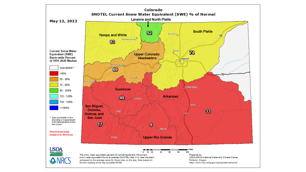
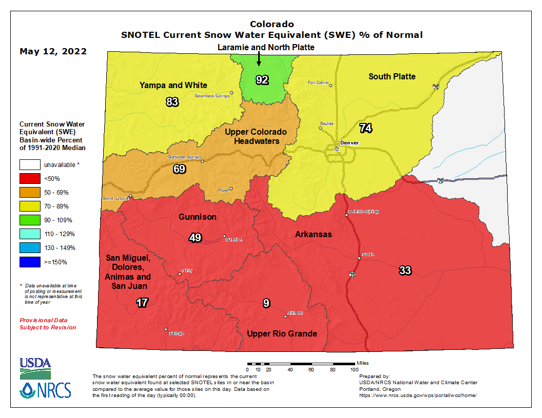
The Upper Rio Grande basin was at just 9% of median levels Thursday compared to the past 30 years – with just 0.6 inches of snow-water equivalent (SWE) remaining, according to U.S. Department of Agriculture data.
That is about comparable with mid-May snowpack in both 2018 and 2002, which were the worst years for snowpack melt in the Upper Rio Grande basin between 1991 and 2020. However, this year differs from those years in that the snowpack peaked around 7 inches of snow-water equivalent those two years, while it reached about 11.5 inches this winter before the quick melt-off.

The San Miguel, Dolores, Animas and San Juan basin was at 18% of median snowpack levels Thursday, with 1.4 inches of snow-water equivalent remaining. In 2002, the worst year in the basin in terms of snowpack melt since 1991, the snowpack reached that level on April 26.
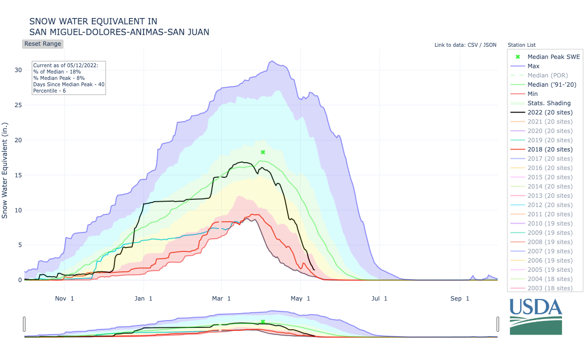
In 2018, which was also comparable in terms of where the snowpack sits as of mid-May in that basin, the snowpack reached 1.4 inches of SWE on May 8.
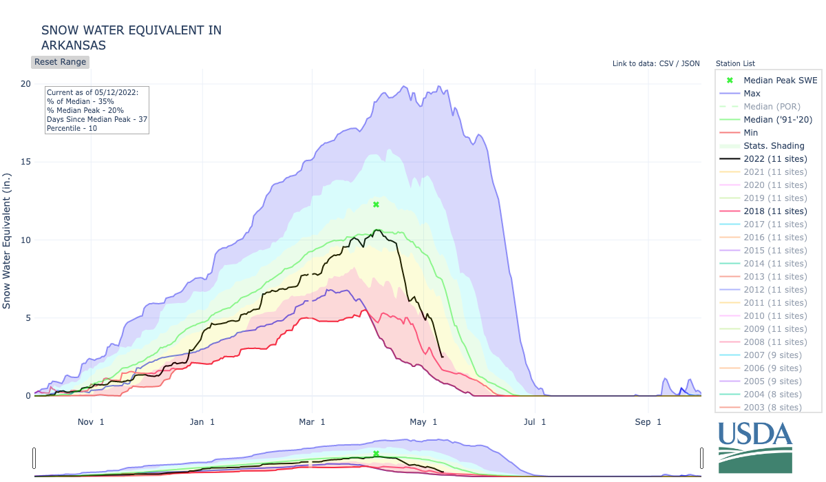
The Arkansas basin was 35% of median levels compared to the past 30 years as of Thursday, sitting at 2.5 inches of snow-water equivalent, according to the USDA data. This time in 2020, it was at similar levels. In 2018, the basin’s snowpack reached 2.4 inches of SWE on May 7, and in 2002, the worst year over the 30-year period, it reached 2.5 inches SWE on April 16.
The Gunnison basin was at 49% of median snowpack levels Thursday, with 4.3 inches SWE left. The Gunnison basin reached the same levels on May 6, 2018, and April 28, 2002, which was the year the snowpack there was gone the earliest.
The Upper Colorado River basin was at 66% of median snowpack levels as of Thursday.
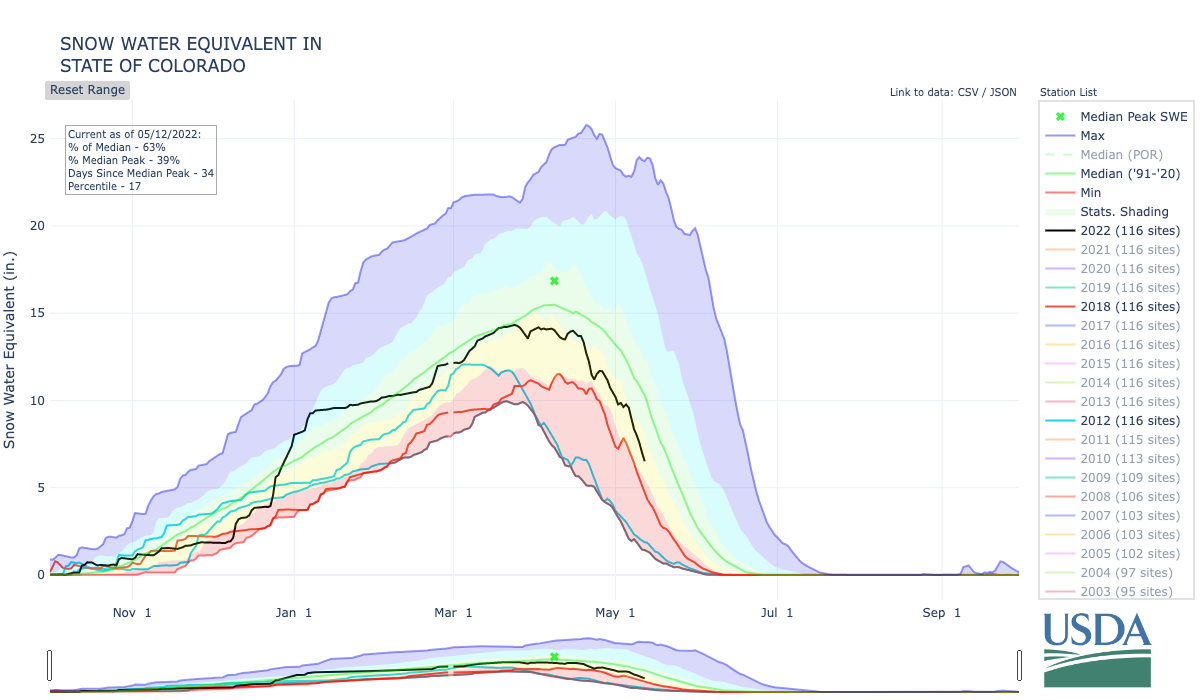
The snowpack in the northern half of the state is faring better than southern Colorado’s, with the South Platte (76%), Yampa and White (84%) and Laramie and North Platte (92%) basins all above three-quarters of median levels as of Thursday. Statewide, the snowpack was at 64% of median as of Friday.
Colorado’s drought has continued to worsen as well, and it will not see any favors with the quick melting of the snowpack.
All of Colorado is at least abnormally dry, and 92% of the state is experiencing moderate or worse drought, according to the U.S. Drought Monitor. Fifty-seven percent of the state is seeing severe drought or worse conditions, and 6% of the state — at the southeastern and southwestern corners and in a pocket on the eastern edges of Adams, Arapahoe and Elbert counties — is now seeing extreme drought conditions.
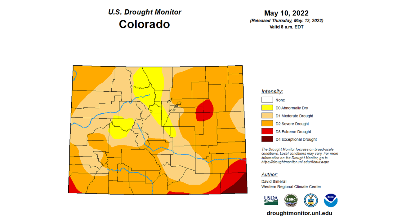
The eastern half of Baca County is currently the only area of the state seeing exceptional drought.
But as with the snowpack, the drought conditions are shaping up similarly to 2018 and 2002, when the quick melting of the snowpack and drought conditions caused conditions ripe for large wildfires throughout the summer.
By late April 2002, 100% of the state was seeing severe drought or worse conditions. By late July that year, all of the state was seeing extreme or exceptional drought, which persisted into September. But 100% of Colorado would stay in severe or worse drought until March 2003.
That summer, the Hayman Fire would burn nearly 140,000 acres in the Pike National Forest, destroying hundreds of structures and homes to the tune of more than $42 million. It remains the fourth-largest wildfire in recorded state history and was the largest until the three major fires of 2020 – Cameron Peak, East Troublesome and Pine Gulch.
The Missionary Ridge Fire also burned more than 71,000 acres in the Durango area, destroying nearly four-dozen homes and structures. Several other fires that summer would burn more than 12,000 acres each across the state.
In May 2018, three-quarters of the state was seeing moderate or worse drought conditions, and about half of Colorado was in severe or worse drought. But by late summer, about two-thirds of Colorado was seeing severe or worse drought, and about half of the state was experiencing extreme or exceptional drought conditions.
That summer, the Spring Fire burned 108,045 acres – turning into what at the time was the second-largest fire in state history. It destroyed more than 140 homes and damaged more than 120 others. The 416 Fire burned 54,000 acres near Durango and at the time was the sixth-largest in state history.
The MM117 Fire in El Paso County burned 42,000 acres and destroyed 23 homes; the Badger Hole Fire burned 33,609 acres in Colorado and another 17,000 in Kansas; and multiple other fires burned more than 12,000 acres in other parts of the state.
There have already been dozens of wildfires so far this spring across the state, fueled by a mixture of drought, waning snowpack, a lack of precipitation, and gusty winds caused by La Niña and the shifting jet stream.
April brought record dry conditions for most of northeast Colorado, the bottom 10th percentile for all of the eastern half of the state and areas of the southwest mountains, according to the Colorado Climate Center.
It was also the windiest April on record since the 1990s for many areas of northeast Colorado,, according to the Colorado Climate Center.


