



DENVER — Heavy rain, large hail and damaging wind gusts are possible Tuesday across Northeastern Colorado, as both severe thunderstorm and flash flood watches have been issued.
Most of the I-25 corridor is included in the severe thunderstorm watch, which is in effect until 8 p.m. A flood watch goes into effect at 3 p.m. and extends across east central and northeast Colorado until 10 p.m.
- Seeing severe weather in your community? Send us a photo or video at newstips@denver7.com.
Denver7 is tracking the latest on these showers and storms, as well as any watches and warnings, in our live weather blog below.
LINKS: Latest forecast | Radars | Traffic | Weather Page | 24/7 Weather Stream
2:26 p.m. | Severe thunderstorm warning | This warning is in place until 3 p.m. for the area around Calhan and Ramah.
2:18 p.m. | Severe weather in northern Colorado | A special weather statement is in place for Longmont and Hygiene until 2:45 p.m. Tuesday. Winds may reach 50 mph and penny-sized hail is possible.
2:03 p.m. | Severe thunderstorm warning | This warning, which impacts Woodland Park, Monument and Palmer Lake, is in place until 2:45 p.m.
2 p.m. | Severe thunderstorm warning | This warning is in place until 2:30 p.m. for an area north of Elizabeth and Kiowa in Elbert County.
1:53 p.m. | Severe thunderstorm warning | The area including and west of Lyons is now under a severe thunderstorm warning until 2:30 p.m. Quarter-sized hail is possible and winds may reach 50 mph.
1:51 p.m. | Flash flood warning | A flash flood warning is in effect until 5 p.m. for a part of Mesa County that is south and southwest of Whitewater, near the Colorado National Monument.
1:35 p.m. | Flash flood warning | The area around Elbert, between Black Forest and Elizabeth, is under this warning until 4:30 p.m. Tuesday. This impacts about 1,300 people. Anybody in low-lying areas should move to higher ground.
1:32 p.m. | Severe thunderstorm warning | The NWS has issued this warning for the areas of Pine Grove and Bailey, west of Buffalo Creek, until 2 p.m. Tuesday.
1:27 p.m. | Latest from National Weather Service | The threat of flash flooding will stay in place over parts of northeast Colorado Tuesday afternoon and evening. A few storms may become severe. The NWS said the state will see similar conditions again on Wednesday.
1:22 | Severe thunderstorm warning | The area around and including Rush is under a severe thunderstorm warning until 2 p.m. Winds may each 60 mph.
1:06 p.m. | Severe thunderstorm watch This watch applies to much of the eastern plains. Hail may reach the size of ping pong balls and scattered wind gusts could blow up to 70 mph. Frequent lightning possible. This watch impacts more than 2,881,000 people, the NWS reports.
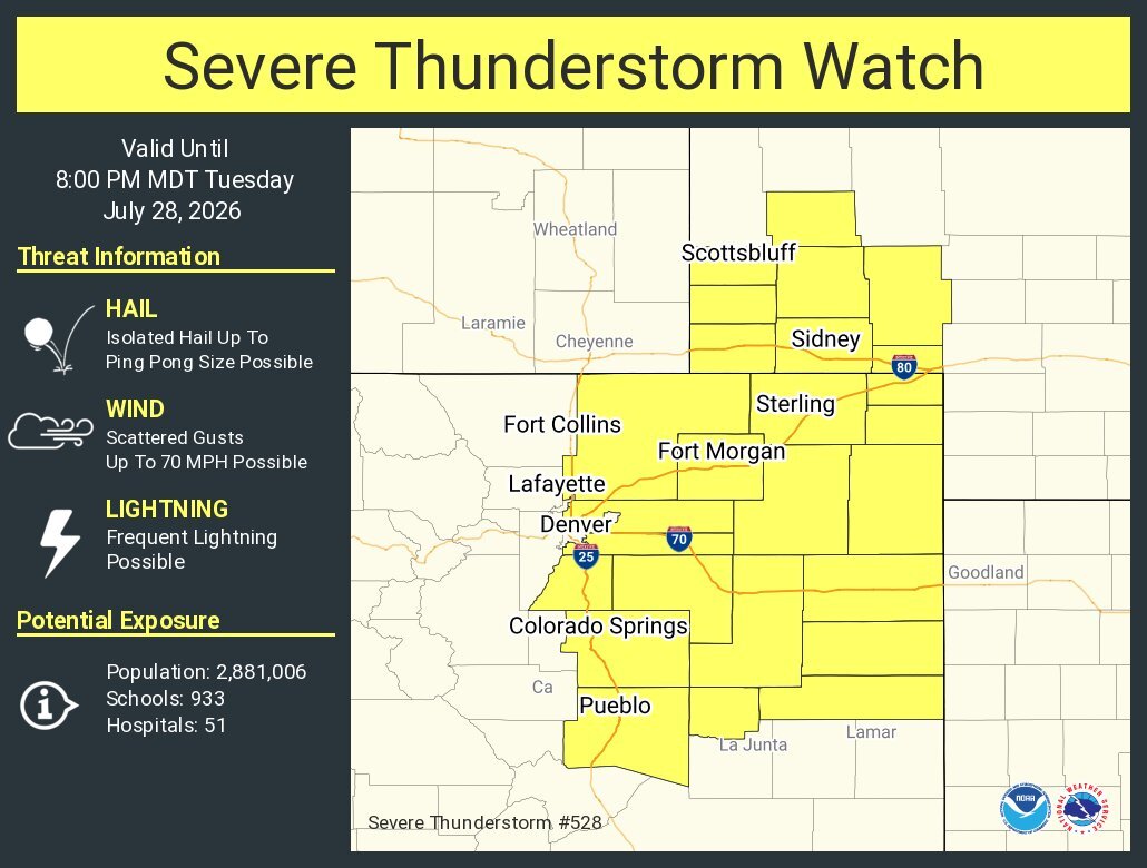
Denver County is not currently under the watch, but many other metro areas are included. Here's the list of counties.
1:06 p.m. | NOCO Alert | NOCO Alert, the emergency notification system for Larimer County, shared more details about a flash flood warning in place for the county. It said the warning impacts the "Buckhorn Creek Basin within the Cameron Peak burn scar area, to include North Fork Fish Creek, Eld Creek, Cedar Creek, Redstone Creek."
1:04 p.m. | Wind and hail around Elbert County | The NWS says a special weather statement has been issued for Elbert County until 1:45 p.m. Winds may reach 50 mph and hail the size of pennies is possible.
1:01 p.m. | Flash flood warning | Flash flooding is likely for an area including and west of Masonville, north of Glen Haven and Drake. Residents are encouraged to move to higher ground if they are in a low area.
1 p.m. | Flash flood warning | This warning continues until 4 p.m. for the community of Beulah and surrounding areas.
3:22 a.m. | Flood watch on Tuesday | The NWS reports that thunderstorms with “torrential rainfall” is possible over parts of northeast Colorado late Tuesday afternoon and evening. The greatest risk of flash flooding will stay east of Interstate 25. Some areas may see rainfall of 2 inches or more in 30 to 45 minutes, the NWS said.