

DENVER — After torrential rainfall caused widespread flooding in parts of the southern metro Denver area Saturday, the threat of isolated flooding continues Sunday.
A flash flood warning remains in effect for south-central Elbert County until 5:30 p.m. after Doppler radar detected thunderstorms producing heavy rainfall across the area.
- Seeing severe weather in your community? Send us a photo or video at newstips@denver7.com.
Denver7 is tracking the latest on these showers and storms, as well as any watches and warnings, in our live weather blog below.
LINKS: Latest forecast | Radars | Traffic | Weather Page | 24/7 Weather Stream
Sunday, August 16
3:50 p.m. | Burn scar flash flood warning | A flash flood warning is in effect for the Aspen Acres burn scar in Beulah, southwest of Pueblo. Several roads are flooded at this time. Authorities say this is a dangerous and life-threatening situation, and they urge people to not attempt to travel through moving or standing water.
3:00 p.m. | Flash flood warning | A flash flood warning remains in effect for south-central Elbert County until 5:30 p.m. after Doppler radar detected thunderstorms producing heavy rainfall across the area. Between 1 and 2 inches of rain have already fallen, with up to an additional inch possible. Flash flooding is already occurring or could begin shortly.
Saturday, August 15
5:05 p.m. | Latest on weather | Denver7's Maggie Bryan and Meteorologist Stacey Donaldson have the latest on today's flooding, hail and storms.
4:45 p.m. | DougCo plow clears streets after hail, flooding | A Douglas County plow cleared the road at the intersection of Meridian Boulevard and Oswego Street after flooding and hail, SMFR shared in a post.
Thanks to a plow from @douglascountyco the intersection of Meridian Boulevard and Oswego Street will be opening soon. Thanks to @dcsheriff for their assistance with traffic control. pic.twitter.com/3nSR0RLeX2
— South Metro Fire Rescue (@SouthMetroPIO) August 15, 2026
3:36 p.m. | Flash flood warning | A flash flood warning is in effect for western Adams, wester Arapahoe and eastern Denver counties through 5:45 p.m.
3:05 p.m. | Flooded intersections |South Metro Fire Rescue and Douglas County sheriff's office are responding to stranded drivers in Meridian Village at "multiple flooded intersections," according to a post from SMFR.
"These conditions are dangerous and life-threatening," SMFR officials wrote in the post.

NWS officials said just before 3 p.m. that rainfall gauges were indicating up to 2 inches of rain "in a short period of time" for the east metro.
2:57 p.m. | DIA ground stop | Departures to Denver International Airport are grounded until 4 p.m. due to thunderstorms. There have been 554 delays and 61 cancellations Saturday at DIA, per Flight Aware.
2:39 p.m. | Elbert County storms with possibility for tornadoes | Elbert County Emergency Management officials said the area could see another round of thunderstorms this afternoon and evening, "with the potential for heavy rainfall, large hail, damaging winds, and isolated tornadoes."
Officials said flooding is also a concern.
Emergency officials provided the following tips for remaining weather-aware:
• Never drive through a flooded roadway
• Avoid low-water crossings and areas already experiencing flooding
• Have multiple ways to receive weather warnings
• Secure outdoor items that could be affected by strong winds
• Consider moving vehicles and equipment under cover due to the potential for large hail
• If a warning is issued for your location, be prepared to take action immediately
2:36 p.m. | Severe thunderstorm warning | A severe thunderstorm warning for an area including Aurora is in effect through 3:15 p.m.
2:20 p.m. | Severe thunderstorm warning |Centennial, Parker and Lone Tree are under a severe thunderstorm warning until 2:45 p.m.
2:10 p.m. | Special weather statement | A special weather statement has been issued for Denver, Lakewood and Arvada through 2:45 p.m.
1:45 p.m. | Flash flood warning | A flash flood warning that includes part of Douglas County is in effect through 4:45 p.m.

1:30 p.m. | Severe thunderstorm warning | Denver, Lakewood, Littleton and other areas of the Denver metro are under a severe thunderstorm warning until 2 p.m.
11:30 a.m. | Severe storm threat | Severe thunderstorms this afternoon and evening are expected to bring damaging winds, heavy rainfall and large hail to the eastern plains and east of the I-25 corridor, according to NWS.
10 a.m. | Flood watch | A flood watch is set to take effect throughout much of the Denver metro and eastern plains from 2-10 p.m. Saturday. Read Denver7 Meteorologist Danielle Grant's forecast for the day here.

Friday, August 14
7:45 p.m. | Flash flood warning | The flash flood warning for part of Elbert County has been extended through 9 p.m.
5:39 p.m. | Flash flood warning | Northwestern Weld County is under a flash flood warning until 8:30 p.m. as storms could drop an additional 1.5" of rain. Here's the NWS alert.
4:56 p.m. | Flash flood warning | Elbert County is under a flash flood warning until 8 p.m. NWS alert here.
4:44 p.m. | Flash flood warning | A flash flood warning that includes Evans and La Salle is in effect until 7:45 p.m.
4:42 p.m. | Severe thunderstorm warning | A severe thunderstorm warning that includes parts of Elbert County is in effect through 5:15 p.m.
4:20 p.m. | Ground stop extended | The groundstop on departures to DIA has been extended through 5:30 p.m.
4:11 p.m. | Flash flood warning | Areas of Lochbuie, Hudson and Keenesburg are under a flash flood warning until 7:00 p.m.
4:09 p.m. | DIA ground stop | Departures to Denver International are grounded through at least 5 p.m. due to thunderstorms.
4:01 p.m. | Flash flood warning | Northwestern Adams and South Central Weld Counties are under a flash flood warning until 7 p.m.
3:58 p.m. | Severe thunderstorm warning | Central and Eastern Arapahoe Counties are under a severe thunderstorm warning until 4:15 p.m. for a cell near Deer Trail, moving east at 10 mph. 60 mph wind gusts and small hail are possible.
3:38 p.m. | Flash flood warnings | In addition to the flash flood warning in effect for parts of the Denver metro, NWS has issued the following flash flood warnings:
- Including Las Animas County until 6:45 p.m.
- Impacting Cache La Poudre River, Cow Creek, Pendergrass Creek, Black Creek, Grouse Creek, Eld Creek, Sheep Creek, Redstone Creek, Pennock Creek, North Fork Big Thompson River, South Fork Cache La Poudre River, Miller Fork, Buckhorn Creek, Big Thompson River and North Fork Fish Creek in Larimer County through 6:30 p.m.
- Including Larimer County until 6:30 p.m.
3:31 p.m. | Denver metro flash flood warning | A flash flood warning is in effect for Denver, Lakewood, Littleton and other areas of the Denver metro through 6:30 p.m.
3:20 p.m. | Severe thunderstorm warning for Denver metro | Quarter-sized hail and 60 mph wind gusts are possible in a cell near Englewood, moving north at 10 mph, according to the NWS.
Western Arapahoe and Denver Counties are under the warning until 3:45 p.m.

3 p.m. | Special weather statement | NWS has issued a special weather statement through 3:30 p.m. for the Denver metro, including Lakewood and Centennial. Nickel-sized hail and 50 mph winds are possible.

2:50 p.m. | Sever storm warning | A severe thunderstorm warning is in effect for Strasburg and Byers until 3:30 p.m.
2:20 p.m. | Flash food warning | Portions of Douglas and Elbert Counties are under a flash flood warning until 5 p.m., according to the NWS in Boulder. Officials told anyone in Castlewood Canyon State Park and Cherry Creek Basin south of Franktown to move to higher ground immediately.

2:08 p.m. | Severe t-storm warning | Quarter-sized hail and 60 mph wind gusts are possible with a storm 5 miles SE of Franktown. The NWS in Boulder issued a severe thunderstorm warning for NW Elbert and East Central Douglas Counties until 2:45 p.m.

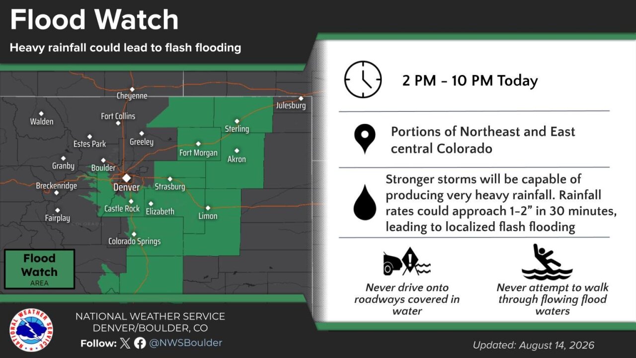
11:30 a.m. | Flood watch in effect | A flood watch has been issued for portions of the plains, the Palmer Divide and Southern Front Range Foothills from 2 p.m. until 10 p.m. tonight.
Counties in the flood watch include Elbert, Lincoln, eastern Adams and Arapahoe, Washington, Morgan, Logan and northeastern Weld.