


DENVER – If you’re planning on hitting I-70 for a trip to one of Colorado’s ski resorts this weekend, be advised heavy snow and high winds could potentially make for treacherous travel conditions starting Friday night and especially Saturday morning.
A winter storm warning will go into effect Friday evening at 11 p.m. through at least 11 p.m. Saturday.
“The snow picks up in intensity Friday night into Saturday morning, so that Saturday morning drive up into the mountains is likely going to get really tricky early,” said Denver7 chief meteorologist Lisa Hidalgo. “For the eastern plains, we’re mainly going to see dry conditions but may see a spotty shower Saturday.”

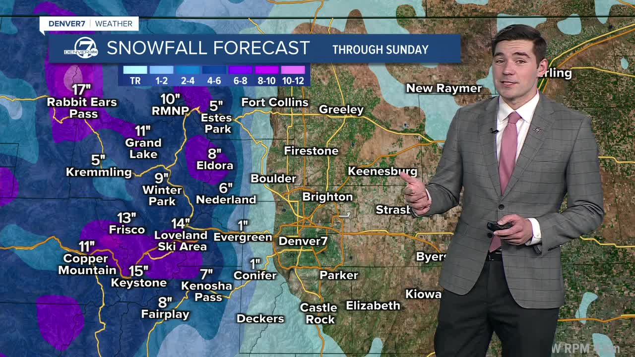
Hidalgo said from 1 to near 2 feet of snow is possible by midday Sunday in some areas of the mountains. You can check potential snow totals scrolling down in this story.
Blowing snow will also be an issue through the weekend.
“You’ll see some of those wind gusts upwards of around 50 to 60 mph up in through the northern and central mountains,” said Hidalgo.

The winter storm warning covers a large portion of the northern mountains with the heaviest of snow expected in the Park Range, according to the National Weather Service (NWS) in Boulder.
“The combination of snow and wind is expected to lead to widespread travel issues across a majority of our mountain passes,” wrote NWS forecasters. “It is strongly recommended to alter travel plans in the northern Colorado mountains Friday night through Saturday night. Travel may become very difficult to impossible. Monitor the latest forecasts for updates on this winter storm.

In a Friday afternon update, The NWS said mountain snow will intensify after midnight and whiteout conditions are possible as winds pick up overnight.
The Denver metro area and the I-25 corridor are not under a winter weather alert and Hidalgo said Saturday in Denver will bring a few showers and a high temperature of 46 degrees. On Sunday, expect sunny skies and mild conditions with temps hovering in the low 40s.

The Colorado Department of Transportation (CDOT) on Friday joined the NWS in warning drivers headed to the high country to remain alert and prepare ahead of time.
"Given the expected snowfall amounts and strong winds, travel will be hazardous, especially throughout the mountains. Motorists contemplating heading to the ski slopes this weekend should ensure they are prepared and may want to consider reserving a lodging as evening travel is going to be especially impacted," wrote CDOT in a news release.
The agency recommended drivers be aware of passenger vehicle traction and chain laws as well as carrying an emergency kit. CDOT recommends drivers check the following items on their vehicles:
- Windshield wiper fluid
- Heater/defroster
- Wiper blades
- Exterior/interior lights
- Fuel system and a full tank of gas
- Ignition
- Exhaust system
- Tire tread (at least 3/16 inch)
- Battery
- Brakes
In case of an emergency, CDOT urges drivers to have in their vehicle a flashlight with extra batteries, gallon jug of water, a first aid kit among other items.
"Portions of the I-70 Mountain Corridor, including Eisenhower-Johnson Memorial Tunnels, Vail Pass and US 40 over Berthoud Pass may see up to a foot of snow. Northern mountain passes, such as Rabbit Ears on US 40, could see up to two feet of snow. Winds are also forecasted to exceed 50 mph, which is expected to make conditions more extreme with blowing snow reducing visibility and potentially causing deep drifts across roadways," added CDOT.

Potential snow totals across Colorado
Below are snow total forecasts first showing expected accumulations and then possible high-end totals through the weekend from the NWS.
- Allenspark: 5” to 10”
- Alma: 9” to 10”
- Bear Lake: 12” to 15”
- Berthoud Pass: 15” to 18”
- Black Hawk: 3” to 6”
- Breckenridge: 9” to 12”
- Cameron Pass: 17” to 21”
- Copper Mountain: 15” to 18”
- Dillon: 7” 10”
- East Portal: 19” to 23”
- Echo Lake: 5” to 8”
- Eldora: 11” to 13”
- Frisco: 11” to 13”
- Fraser: 9” to 11”
- Georgetown: 7’ to 10”
- Gould: 8” to 14”
- Granby: 8” to 10”
- Heeney: 6” to 8”
- Hoosier Pass: 14” to 18”
- Hot Sulphur Springs: 8” to 10”
- Idaho Springs: 2” to 5”
- Keystone Ski Area: 10” to 15”
- Kenosha Pass: 5” to 9”
- Kremmling: 6” to 7”
- Loveland Pass: 16” to 19”
- Milner Pass: 16” to 21”
- Muddy Pass: 26” to 32”
- Nederland: 5” to 9”
- Rabbit Ears Pass: 32” to 38”
- Rollinsville: 4” to 8”
- Spicer: 10” to 20”
- Vail Pass: 18” 22”
- Walden: 4” to 9”
- Willow Creek Pass: 9” to 16”
- Winter Park: 11” to 15”
Stay with Denver7 for winter weather updates through the weekend.

DENVER WEATHER LINKS: Hourly forecast | Radars | Traffic | Weather Page | 24/7 Weather Stream
Click here to watch the Denver7 live weather stream.