


DENVER — More snow is expected later Sunday evening in the mountains, though not as heavy as what fell earlier in the day. The National Weather Service forecast shows decent moisture lingering over the mountains until early Monday morning.
A winter storm warning remains in effect for the north central mountains through 5 a.m. Monday. Travel in the high country remains treacherous as areas of heavy, blowing snow is possible through the evening hours.
The heavy snowfall is welcomed news for Colorado’s ski resorts, but you’ll want to check Colorado road conditions if you’re making your way back home if you’re spending the day on the slopes. Winter driving conditions mean chain and traction laws are in effect.
“Winter weather advisories are posted from northwestern Colorado, Rabbit Ears Pass, over the I-70 corridor and especially over Vail pass, we’ll definitely see some areas of blowing snow as it comes down heavy at times,” said Katie LaSalle, Denver7 weather forecaster. “Great news, we need the snow, especially for our ski resorts but we could definitely see some issues on our roadways. CDOT is out there and be safe if you’re traveling back down the hill later on tonight.”
“If you are planning to travel over Rabbit Ears Pass today, consider altering your plans. Heavy snowfall is expected to make travel very difficult to impossible through this evening,” said the NWS.
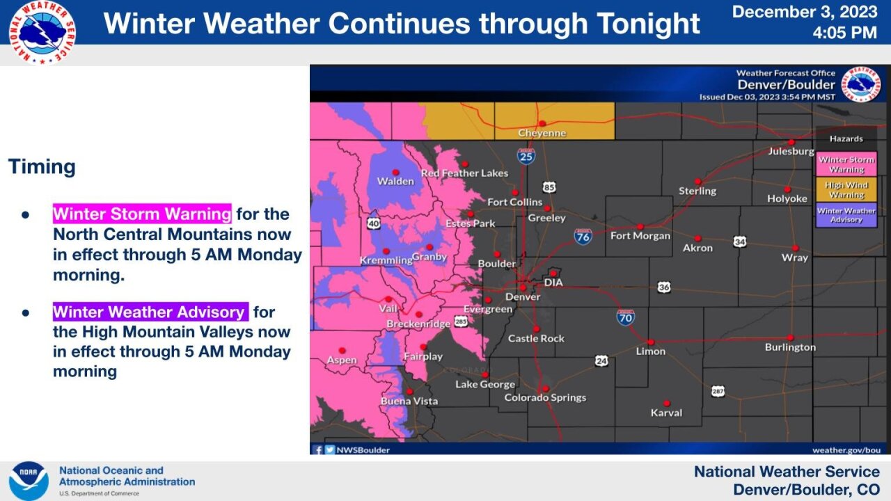
Colorado’s northern and central mountain ranges can also expect more heavy snow accumulations through Sunday. A winter storm warning also remains in effect until 11 p.m. Sunday for Rocky Mountain National Park, Medicine Bow Range, Mountains of Summit County, Mosquito Range and the Indian Peaks.
The Colorado Avalanche Information Center has also issued an avalanche warning through 5 p.m. Monday for Park Range, Elk Mountains and Ruby Range. The NWS said large and dangerous avalanches could easily be triggered along the northern and east-facing slopes and backcountry travel is not recommended.
High winds should also be expected in Colorado’s foothills Sunday.
A high wind warning remains in effect for the Northern and Southern Front Range Foothills for westerly winds from 30 to 50 mph and some peak wind gusts of 80 mph expected, said the NWS.
The high wind warning includes higher elevations of Larimer and Boulder Counties and also includes Westcreek, Evergreen, Georgetown, Estes Park, Nederland, Idaho Springs, and Bailey.
You can check all Colorado winter weather alerts as they are updated.
While the heavy snow will remain in Colorado’s mountains, light flurries will linger in Denver metro communities Sunday morning with windy conditions in the afternoon only warming up into the mid-40s.
The storm system quickly blows through leaving behind partly cloudy conditions and a high of 55 degrees in Denver for Monday. Then a warmup returns to Denver’s 7-day forecast as sunny skies and high temperatures in the 60s await for Tuesday through Thursday.
WEATHER LINKS: Closings and Delays | Latest forecast | Radars | Traffic | Weather Page | 24/7 Weather Stream
You can always watch 24/7 weather, radar and news updates on the free Denver7+ app on your TV.
Click here to watch the Denver7 live weather stream.