


DENVER — Denver's snowless streak is expected to come to an end starting late Friday evening as a storm system brings up to 7 inches of snow in the mountains and anywhere from a trace to possibly 3 inches along the plains.
While most travel impacts should remain in the higher elevations, Denver could see light accumulations.
We're tracking the latest weather conditions, alerts and travel impacts in the Colorado weather blog below. Refresh this page for updates.
LINKS: Closings and Delays | Latest forecast | Radars | Traffic | Weather Page | 24/7 Weather Stream

Saturday, November 29
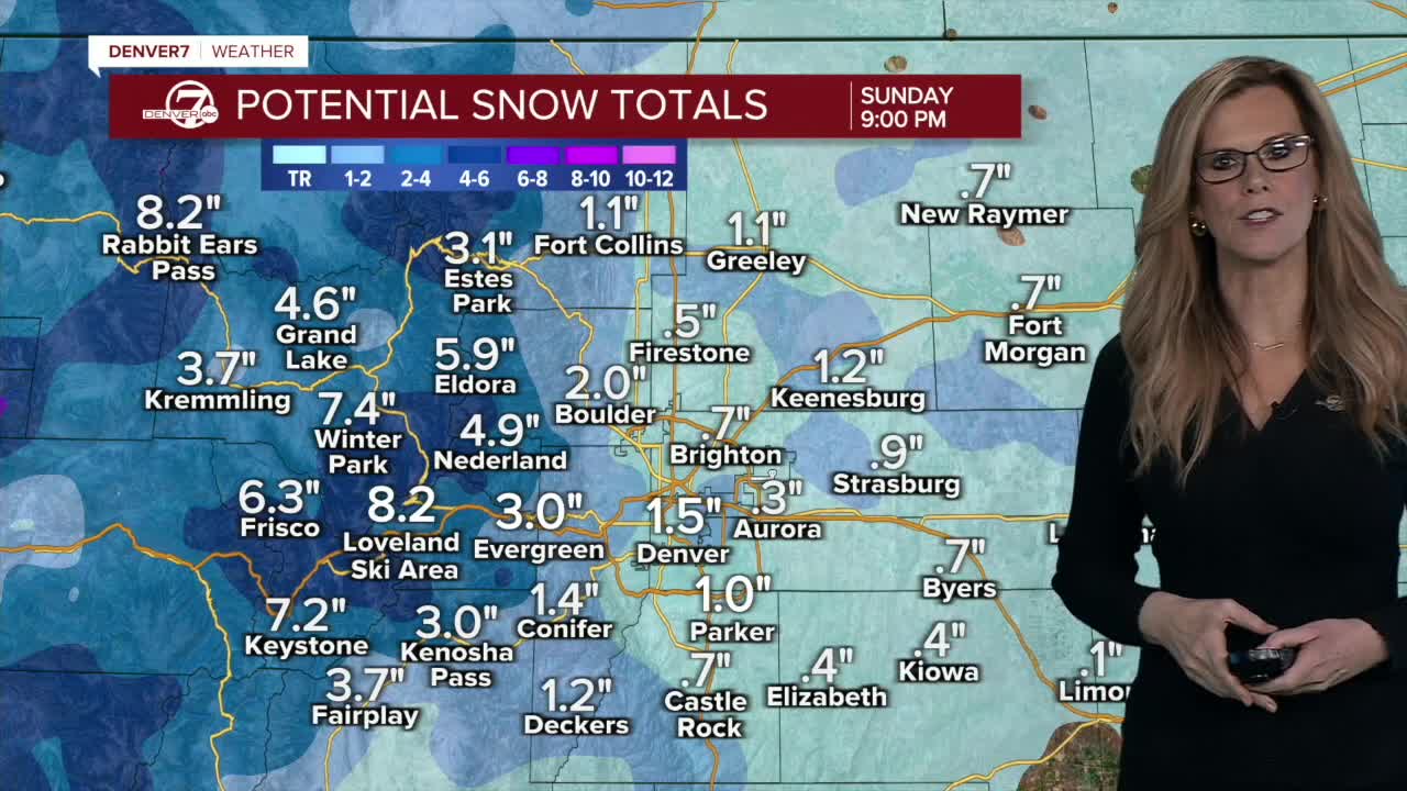
12 p.m. | Snow for the resorts | Denver officially broke its snowless streak, but the storm was even more beneficial for ski resorts that were hurting for some powder. Arapahoe Basin reported 7 inches of snow, while Keystone, Breckenridge and Winter Park all boasted at least 5 inches. Copper Mountain saw four fresh inches.
11:45 a.m. | Denver crash alert lifted | The Denver Police Department lifted its crash alert policy around 11:45 a.m. Saturday. If you are involved in a crash, please call police as normal.
8 a.m. | End of 'snow drought' | Denver International Airport reported 0.2 inches of snow Saturday morning, officially ending Denver's "snow drought, according to the NWS in Boulder. The snowless streak marks the second latest snowfall on record for the city.
7:15 a.m. | Crash alert | The Denver Police Department is on crash alert Saturday morning. Only call police under the following circumstances:
- Someone is injured or injury is unknown
- The crash is blocking streets
- City property, vehicles or personnel are involved
- An involved driver is under the influence of drugs or alcohol
- A driver fails to provide proof of insurance or driver's license
If none of these apply, DPD asks drivers to exchange information and file a report online at denvergov.org/police.
The Douglas County Sheriff's Office is also on crash alert. The sheriff's office asks residents to file an online report or call 303-660-7500.
The sheriff's office recommends exchanging names, addresses, telephone numbers, dates of birth, driver's license numbers, vehicle year/make/model/color/license plate numbers and insurance polices before leaving the area.

4:45 a.m.| Snowfall begins| Light snow began falling across lower elevations just before 5 a.m. Saturday. The NWS in Boulder says most snow will clear out by 8 a.m. The NWS reports slick spots across the metro area.
Friday, November 28
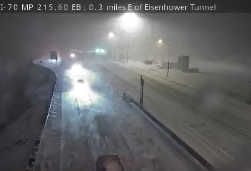
11:30 p.m. | I-70 check | The NWS in Boulder posted a photo at Eisenhower Tunnel on I-70 showing "difficult travel" conditions. At this link, you can check CDOT's alerts.
10:15 p.m. | Flash freezing a possibility | With the temps dropping so quickly, Denver7 meteorologist Stacey Donaldson said to watch for any icy conditions on roads in the morning hours. Rain is expected to change over to snow late Friday and overnight.
8:30 p.m. | Latest forecast | Denver7 meteogologist Stacey Donaldson is updating the forecast: "As we get into Friday night and into Saturday morning, temps will drop into the 20s with chances for our first snow in Denver. Then another shot arrives Sunday night. It looks like travel will be slow going into Saturday morning, especialy up in the High Country."
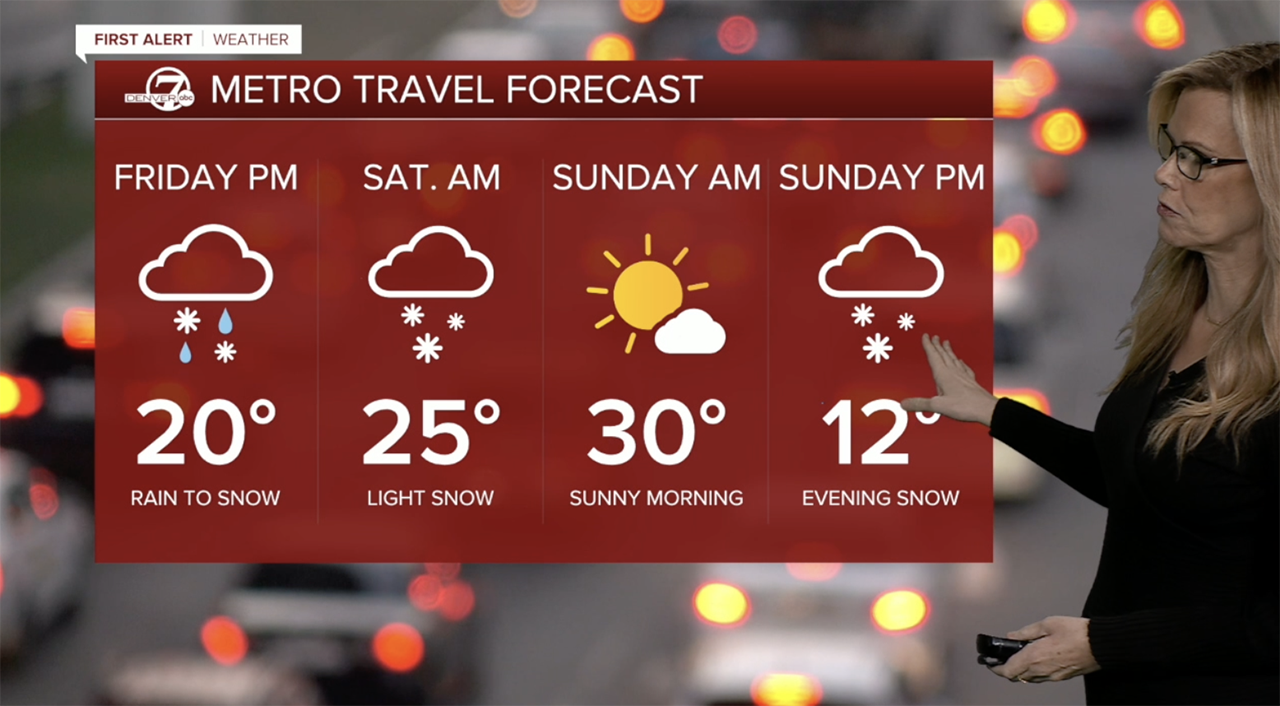
5:00 p.m. | Winter weather advisory | Between 3 and 7 inches of snow is possible in portions of the High Country where a winter weather advisory is in effect until 8 a.m. Saturday. The Eisenhower Tunnel is included in the advisory area.
"Travel will become slick and hazardous by this evening. Conditions will improve again by mid to late morning Saturday," wrote NWS forecasters in Boulder. Check the alert area here.
Click here to watch the Denver7 live weather stream.