


DENVER — Severe storms are firing along Colorado's northeastern plains as a severe thunderstorm watch has been issued for several counties until 9 p.m. Friday.
Multiple warnings, including a tornado warning have been issued.
The National Weather Service (NWS) in Boulder said large hail, damaging wind gusts and isolated tornadoes were possible. The severe thunderstorm watch is in effect east of the metro and Denver is not included in the alert.
The Denver7 news team is tracking the latest Colorado severe weather alerts and conditions across the metro.
Refresh this page for updates and keep checking back for new details.
LINKS: Latest forecast | Radars | Traffic | Weather Page | 24/7 Weather Stream

Friday, May 23
6:45 p.m. | Akron tornado | Landon Moeller (@landon_wx on X) captured this incredible photo of the tornado north of Akron at around 5:53 p.m.

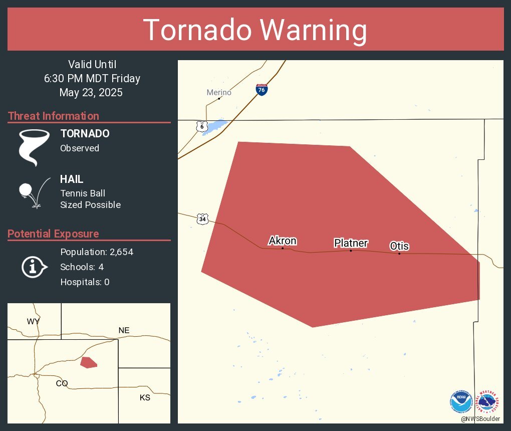
6:39 p.m. | Tornado warning expires | The tornado warning for Washington County expired at 6:30 p.m. A severe thunderstorm warning remains in effect for the county until 7:15 p.m. and includes the communities of Otis and Platner. Two inch-sized hail is possible, warned the NWS. While the tornado warning expired, tornadic activity is still possible in the area.

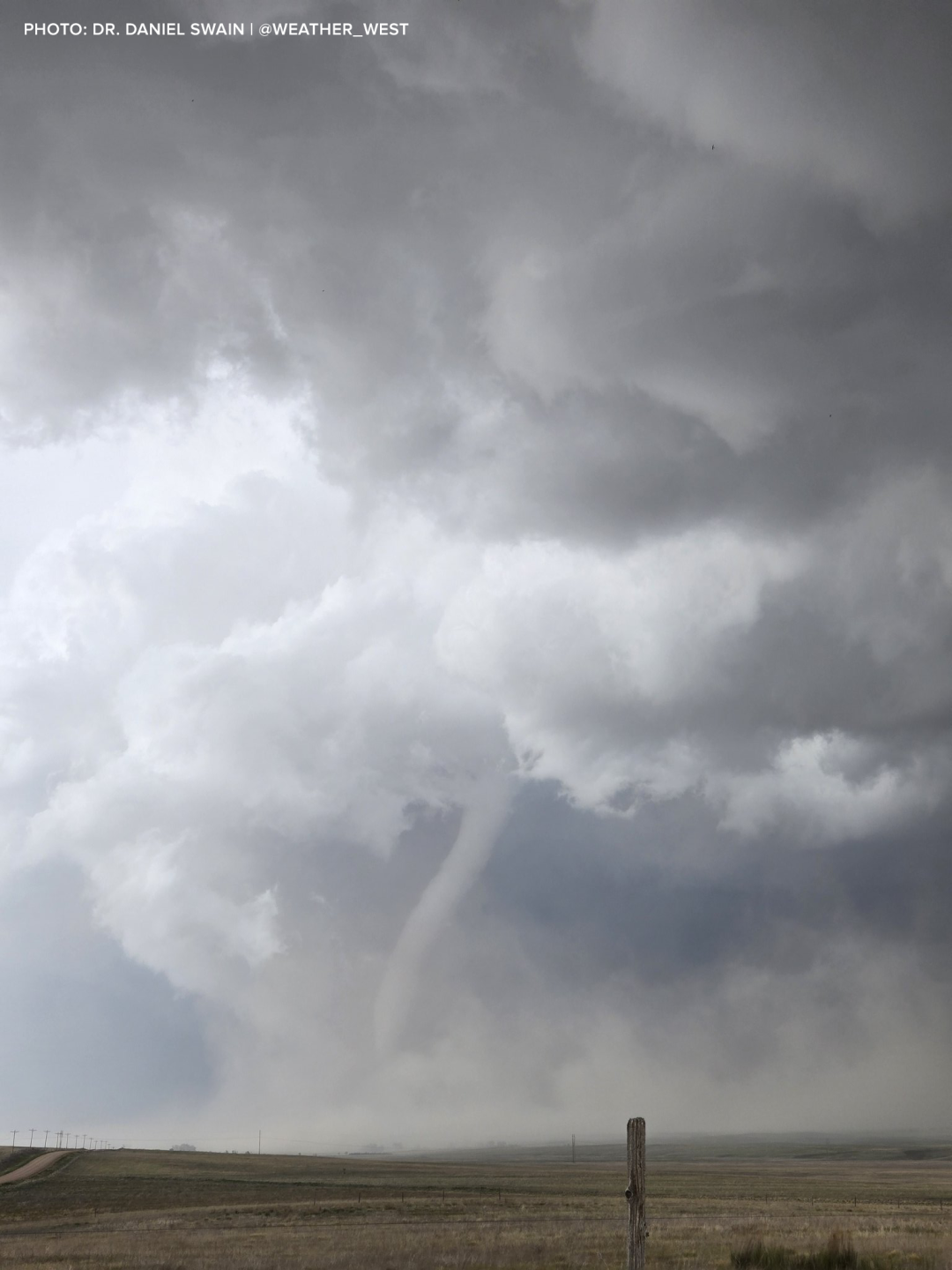
6:27 p.m. | 'Cone tornado on the ground' | This photo of a tornado 6 miles NW of Akron was captured at around 5:45 p.m. by Dr. Daniel Swain (@Weather_West). "Cone tornado on the ground, with multiple additional gustnado/landspout spin-ups nearby," wrote Swain on X.
6:27 p.m. | Tornado near Akron | Brandon Hammons on X captured this photo at 5:56 p.m. of the tornado near Akron.

6:10 p.m. | Severe t-storm warning | In addition to a tornado warning, the NWS said golf ball-sized hail was possible in Washington County where a severe thunderstorm warning is in effect until 7 p.m. The tornado warning continues until 6:30 p.m.
5:48 p.m. | Tornado warning continues Washington County | The NWS extended the tornado warning for Washington County including the areas of Akron, Otis and Platner until 6:30 p.m.
The NWS said a confirmed tornado was reported 8 miles north of Akron and moving southeast at 20 mph.
5:48 p.m. | Tornado near Akron | The NWS reposted a photo from @clevelandkahner showing a tornado north of Akron.
Confirmed tornado just north of Akron. Take shelter immediately! #cowx https://t.co/Y8K38lJLee
— NWS Boulder (@NWSBoulder) May 23, 2025
5:39 p.m. | Tornado warning extended | Washington County remains under a tornado warning now until 6 p.m. with the potential for tennis ball-sized hail, said the NWS.
The tornado was radar-indicated.

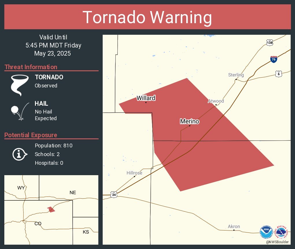
5:33 p.m. | Confirmed tornado near Prewitt Reservoir | Law enforcement at 5:29 p.m. confirmed a tornado near Prewitt Reservoir "or 16 miles northwest of Akron, moving southeast at 25 mph," said NWS forecasters.
Golf ball-sized hail was also reported.
The tornado warning for SW Logan and North central Washington Counties until 5:45 p.m.,
5:26 p.m. | Golf ball-sized hail near Sterling | The NWS said a severe thunderstorm warning remains in effect near Sterling, Merino and Atwood Colorado until 5:45 p.m. where golf ball-sized hail and wind gusts up to 60 mph.
5:14 p.m. | Tornado warning North Central Washington, SW Logan Counties | Trained spotters confirmed a tornado near Merino, or 11 miles southeast of Sterling, moving at 20 mph, according to the NWS.
The tornado warning is in effect until 5:45 p.m.
Communities impacted: Merino, Prewitt Reservoir, Atwood, Logan Corners, Willard and Messex.
4:57 p.m. | Severe thunderstorm warning | The NWS has issued a severe t-storm warning for southeastern Washington County for golf ball-sized hail and wind gusts up to 60 mph. The NWS said the severe storm was moving northeast at 30 mph and was around 30 miles southeast of Akron.
4:54 p.m. | Large hail reported near Westplains | Spotters reported 2.5 inch diameter hail at around 4:20 p.m. 11 miles west of Westplains, Colorado — which is in far northeastern Colorado near the Nebraska border.
4:40 p.m. | Severe T-storm warning extended | Weld and Logan Counties remain under a severe thunderstorm warning until 5:15 for large, damaging hail. The alert was set to expire at 4:45 p.m.
4:38 p.m. | Golf ball-sized hail | Cope, Colorado should be on alert for golf-ball sized hail as a severe thunderstorm passes through the area.

4:35 p.m. | Baseball-sized hail | The NWS said a severe thunderstorm near Willard and Stoneham Colorado is "a destructive storm" and will "contain baseball-sized hail."
Logan and Weld Counties continue under a severe thunderstorm warning until 5:15 p.m.

4:15 p.m. | Stong storms possible | NWS weather forecasters said the severe storm potential is increasing this afternoon for Colorado's NE plains.
"Storms are quickly developing across northeastern Colorado. Large hail is the primary threat, but damaging winds and an isolated tornado will be possible with stronger storms as they drift southeast over the next couple of hours," wrote the NWS.

4:05 p.m. | Severe t-storm warning | Portions of Logan and Weld Counties are under a severe thunderstorm warning until 4:45 p.m. for wind gusts up to 60 mph and ping pong-sized hail.

3:00 p.m. | Severe thunderstorm watch | Here are the counties on the plains included in the watch.

Click here to watch the Denver7 live weather stream..