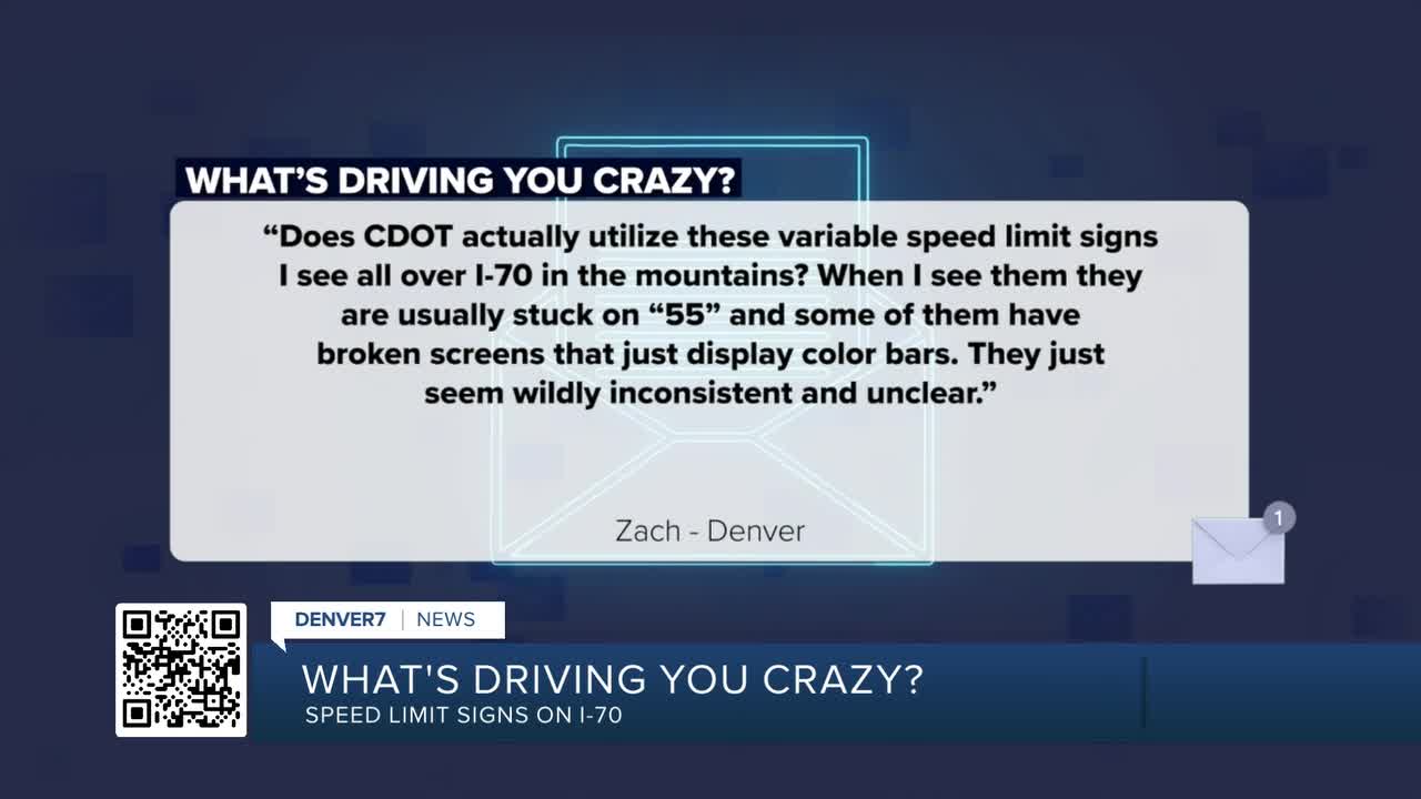


DENVER — Zach from Denver writes, “What’s driving you crazy? Does CDOT actually utilize these variable speed limit signs I see all over I-70 in the mountains? When I see them they are usually stuck on "55" or "test" and some of them have broken screens that just display color bars. They just seem wildly inconsistent and unclear.”
Welcome to the future, Zach, where life is going electronic.
The Colorado Department of Transportation (CDOT) has installed 65 of these variable speed limit signs (VSLs) west of Denver. These LED electronic versions of the more traditional speed limit signs are set up along much of Interstate 70 between Golden and Glenwood Springs. Unlike the typical static signs, these digital signs display enforceable speed limits in real time, based on current highway conditions. There is also a project under construction that will add 22 more VSL signs to I-70 between Genesee and W. Colfax Avenue. There are an additional four VSL signs that are on US-285 between Kenosha Pass and Como in South Park.
On a recent trip to western Colorado, I noticed that most of the VSLs on Highway 285 as well as a majority of the signs on I-70 west of Vail were not working. The signs were either off or showed a black screen. Most of the signs I saw, east of Vail along I-70, were working normally though.
I am told the way the system works is that vehicle speed, traffic volume and weather detectors gather consistent traffic and weather data in real time. The system will then interpret that data and automatically adjust the displayed speed limit on the VSLs based on congestion, traffic conditions and adverse weather such as a snowstorm or icy roads. The system will automatically change the speed limit based on specific, predetermined criteria. CDOT told me all the VSLs around the state are continuously monitored by the 24/7 operators in the three CDOT operations centers located in Hanging Lake, the Eisenhower-Johnson Memorial Tunnels and in the Traffic Operations Center in Golden. Any of the operators in those locations can take over, shut down or override the whole system or individual signs, but I’m told they almost never need to.
MORE: Read more traffic issues driving people crazy
I’m told by CDOT that specifically, for the eastbound I-70 Mountain Corridor, the Mountain Express Lanes near Idaho Springs, between Eagle and Vail, and the Glenwood Canyon, there are sensors mounted on or near the VSL sign posts that collect traffic volume and speeds.
“There are also roadway friction and visibility sensors at varying intervals depending on how much the terrain varies, but generally 3 miles or less - some of these are mounted alone on poles along the side of the road, others are co-located with full roadway weather information station installations that can be viewed through COtrip.org,” CDOT said.
Most of the other VSL locations are associated with Chain Up or Chain Down stations. They will display a lower speed limit when the chain stations are in use to alert drivers in the area to slow down. Those signs are controlled manually, not electronically.
CDOT believes posting appropriate speed limits in real time should help prevent crashes that can occur at higher speeds and could reduce the chances of secondary crashes as well as improve traffic flow. One example the agency provided me was lowering the speed limit to slow traffic ahead of an existing crash along the highway to hopefully reduce the chances of a secondary crash. CDOT said the variable speed limits will only change when poor weather conditions or traffic congestion that warrant a change is detected. An Ohio DOT study found that using VSLs reduced crashes during snow events by 35%. CDOT preliminary data shows a 20% reduction in total crashes in the eastbound Mountain Express Lanes since the system began, with most improvement during peak travel times.
I asked CDOT’s I-70 Mountain Corridor Communications Manager Austyn Dineen how the data that is collected from the road sensors is analyzed and what criteria is used to determine the new speed limit? She told me:
“VSL systems adjust speed limits in several ways, and the system operates differently depending on the location of the system.
- For eastbound I-70 Mountain Express Lanes, the stretch between Eagle Vail and Vail, and the planned system eastbound from Genesee to West Colfax, as traffic volume approaches saturation, it lowers speed limits based on historical volume and crash data specific to that location. It also monitors traffic farther down the road; if congestion is detected ahead, speeds are reduced for approaching vehicles to lower the risk of secondary crashes and help reduce congestion buildup. Road friction is also factored in—during rain, snow, or icy conditions, speeds are reduced so drivers can still stop safely within the same distance they could on dry roads. If both high volume and low friction are present, the system sets speeds based on what would be safe in high-volume dry conditions, resulting in even lower limits. Visibility is another factor; when fog, snow, smoke, or spray reduce how far drivers can see, the system lowers the speed limit to ensure drivers can stop within their visible range.
- In Glenwood Canyon, the VSL system works differently. Traffic volumes there aren’t high enough to justify speed adjustments based on volume, so the system only responds to weather conditions. While the same sensors are present, the system doesn’t use them for volume-based changes. Before automation was introduced, VSL signs were manually operated from the Hanging Lake Tunnel Operations Center, which still takes control during incidents or lane closures.
- Other VSL locations, such as chain stations, are controlled manually as well. These reduce speed limits when chain laws are in effect and chains are required on tires.”
The Colorado State Patrol (CSP) said the speed limit that is posted on the VSLs is the enforceable speed limit and is not a recommended or suggested speed limit. This means that a driver traveling over the variable limit shown on the electronic sign can be ticketed for speeding. I’m told that if a speed limit isn’t shown on the VSL sign or the sign is malfunctioning, drivers should follow the posted speed limit on the last speed limit sign
I also asked CDOT a hypothetical question, if someone is using their Google Maps or similar that shows what the speed limit on the app, it typically displays the speed limit for that stretch of I-70 as 65 or 75 mph. So when the speed limit changes, is there a way to change the speed limit on those apps?
“Of course, what these third parties do is beyond CDOT's control. However, it would be possible for CDOT to provide a live feed of posted speeds on all VSL signs. To date, no company has approached CDOT requesting this data. That said, some in-car systems in newer vehicles already correctly read the VSL signs.”
Denver7 Traffic Expert Jayson Luber says he has been covering Denver-metro traffic since Ben-Hur was driving a chariot. (We believe the actual number is over 25 years.) He's obsessed with letting viewers know what's happening on their drive and the best way to avoid the problems that spring up. Follow him on Facebook, Twitter or Instagram or listen to his award winning Driving You Crazy podcast on any podcast app including iTunes, iHeartRadio, Spotify, Podbean, or YouTube.
WHAT'S DRIVING YOU CRAZY? DENVER7'S JAYSON LUBER ANSWERS YOUR QUESTIONS.
-

Driving You Crazy: The roundabouts on Lowry Boulevard make no sense
-

Drivers aren't stopping outside senior living building on Federal Blvd.
-
Why is Arvada's Ralston Rd. between Wadsworth & Lamar 2 different speed limits?
-

Why has the City of Aurora not upgraded its old sodium streetlights to LED?
-

Driving You Crazy: Law regarding use of red, blue lights in construction zones?


