


DENVER — New evacuation orders were issued by fire officials Wednesday as strong winds and dry conditions in the Western Slope pushed at least two wildfires into new territory by the afternoon.
Mandatory evacuation orders were issued northwest of Rifle after the southern edge of the Lee Fire reached the Garfield County line.
Those evacuation zones included boundaries of the Garfield County line to the north, Roan Cliffs Road to the east, Long Ridge to the south, and Garfield County roads 401 and 402 to the west, according to the evacuation map from the Rio Blanco County Sheriff's Office.
The Garfield County Sheriff's Office reported that two of the evacuation zones are on top of the Roan Plateau in an industrial landscape and within public lands, not residential areas.
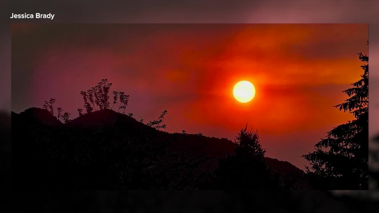
Still, residents in Garfield County know just how quickly the fires can change, and Jessica Brady is ready to react.
"It leads to a lot of anxiety, and just always being on a high alert," said Brady, who lives in New Castle. "Is it going to go West? Is it going to go East? South? And every single day, I'm paying attention to that so, you know, it's exhausting in a way."
The car is packed at Brady's home, and she's prepared to grab her two cats and evacuate if necessary.
"I can't see the fire, but I can definitely smell it," Brady said about the Lee Fire. "The other day, we woke up and I couldn't even see the Hogback Mountain... I thought my house was on fire. There was so much smoke, it was in my house."
Denver7 spoke with an Incident Commander Trainee with the Rocky Mountain Complex Incident Management Team 3 about the Lee Fire on Wednesday. Benjamin Sanders explained why the containment on the Lee Fire decreased.
"The fire gained acreage, which decreased our containment on this fire," Sanders said.
Sanders said there are currently 1,284 personnel working between the Lee and Elk Fires.
Evacuation orders were also issued for the Crosho Fire shortly before 4 p.m. after the blaze crossed east into Routt County.
Those evacuations were in effect along an area close to Spronks Creek to the north, North Hunt Creek to the west, the Allen Basin Reservoir to the south, and Highways 17 and 15 to the east, per the Routt County Emergency Alert evacuation map.
Hotter weather, drier conditions and strong winds Wednesday were a challenge for crews battling more than a dozen wildfires across Western Colorado, with fire officials warning conditions could lead to more fire growth before the day's end.
At least 15 fires have burned more than 198,000 acres across Delta, Dolores, Garfield, Grand, Mesa, Moffat, Montrose, and Rio Blanco counties, as well as in parts of eastern Utah, with the state's fifth-largest fire in history burning near Meeker.
As a result, Governor Jared Polis has mobilized the Colorado National Guard to support response efforts for Rio Blanco County, and has verbally declared a disaster declaration for fires elsewhere in the Western Slope. FEMA has also authorized the use of federal funds to help with firefighting costs.
The fires are being fueled by extreme drought conditions in the Western Slope, with a large swath of the western half of the state experiencing moderate and severe drought, according to the latest data from the U.S. Drought Monitor.
- Denver7 has created the map below to give you a better idea of where these fires are located. Click on the red dot to view more information about each one.
We're tracking the latest updates on these fires below.
Crosho Fire
Size: 1,700 acres
Containment: 0%
First reported: Aug. 11 at 3:25 pm.
Cause: Under investigation
Location: Crosho Lake in the Routt National Forest in Rio Blanco County
Evacuations 🏠: South Sprongs Creek to the north, North Hunt Creek to the west, the Allen Basin Reservoir to the south, and Highways 17 and 15 to the east,
Pre-evacuations: Residents in the area bordered by County Road 19 to the north, Highway 131 to the east, County Road 13 to the south and the Crosho Lake area to the west are included.
The Crosho Fire is burning immediately adjacent and north of Crosho Lake in the Routt National Forest in Rio Blanco County, fire officials said Tuesday.
While pre-evacuation areas have been established, they are likely to change, so residents are advised to click here to view the latest evacuations/pre-evacuation map.
An evacuation center has been established at South Routt Elementary School, located at 448 Main St. in Yampa.
In a Wednesday update, fire officials said the fire was active overnight and has burned into Routt County and onto private land.

Nearby landowners and ranchers were contacted by fire officials and plans to move livestock if needed were made, they said. Transition to a Type III Incident Management Team will occur Wednesday afternoon.
The following roads are closed, effective immediately, due to the Crosho Fire and response efforts:
- Intersection of Routt County Road 15 and Routt County Road 17
- Intersection of Routt County Road 25 and Routt County Road 132A
- Rio Blanco County Road 8 (Dunckley Pass) at mile marker 38
Chapman Reservoir Campground and dispersed camping in the Crosho Lake area are closed.
Updates posted to:
InciWeb
Rio Blanco County Sheriff's Office
Elk Fire
Size: 14,521 acres
Containment: 75%
First reported: Aug. 2
Cause: ⚡️
Location: 11 miles east of Meeker
Evacuations 🏠: No current evacuations
Pre-evacuations: No pre-evacuations at this time
The lightning-sparked Elk Fire, first reported on Aug. 2, is burning 11 miles west of Meeker in Rio Blanco County.
Two homes and two outbuildings have burned in the Elk Fire, according to officials in Rio Blanco County, who said crews have made substantial progress when it comes to containment around the perimeter.
On Wednesday, crews will continue reinforcing containment lines off County Road 8 and in the Beaver Creek area as they patrol and mop up any hotspots. They'll also continue working to secure lines on the west side of the fire.

The following road closures are still in effect, according to the Rio Blanco County Sheriff's Office:
- CLOSED HIGHWAYS: Highway 13 South Highway 13 Closure Area: in both directions between Piceance Creek Road (15 miles north of Rifle)
- RESTRICED TO LOCAL TRAFFIC ONLY COUNTY ROADS: County Road 13 (residents who live in the area).
- CLOSED COUNTY ROADS: County Road 5, 22, 33, 40, 45, 47, 49, 63, 66, 67, 117,127, 129
The Rio Blanco County Sheriff's Office said a partial closure of the White River National Forest was also in effect due to the fire within the Blanco Ranger District west of and including the Long-Lost Trail system.
Updates posted to:
Elk and Lee Fire Information
Rio Blanco County Sheriff's Office
Lee Fire
Size: 123,222 acres
Containment: 4%
First reported: Aug. 3 at 1 p.m.
Cause: ⚡️
Location: 18 miles southwest of Meeker, Colo.
Evacuations 🏠: County Road 22 (Little Hills) off of County Road 5; at the County Road 76 intersection from County Road 3 to County Road 5; Highway 64 between mile marker 58 and mile marker 67, including those on County Road 127, County Road 129, County Road 66 and Bridgewater Lane
Pre-evacuations: County Road 22 (Little Hills) off of County Road 5, as well as for residents along County Road 33
Three homes and 12 outbuildings have burned so far in the Lee Fire, according to officials in Rio Blanco County, who said crews continued securing firelines around structures and other values at risk Tuesday.
Firefighters will focus Wednesday on improving containment lines west of Highway 13 and south of Highway 64, as they work on constructing firelines around the spot fire below County Road 5.

The following road closures are still in effect for residents in Rio Blanco County:
- CLOSED HIGHWAYS: Highway 13 South Highway 13 Closure Area: in both directions between Piceance Creek Road (15 miles north of Rifle)
- RESTRICED TO LOCAL TRAFFIC ONLY COUNTY ROADS: County Road 13 (residents who live in the area).
- CLOSED COUNTY ROADS: County Road 5, 22, 33, 40, 45, 47, 49, 63, 66, 67, 117,127, 129
The Rio Blanco County Sheriff's Office said a partial closure of the White River National Forest was also in effect due to the fire within the Blanco Ranger District west of and including the Long-Lost Trail system.
Updates posted to:
Elk and Lee Fire Information
Rio Blanco County Sheriff's Office
InciWeb
Oak Fire
Size: 75 acres
Contained: 78%
First reported: Aug. 10
Cause: Structure fire
Location: Archuleta County west of Pagosa Springs
Evacuations 🏠: No evacuations at this time
Pre-evacuations: No pre-evacuations at this time
At least one small barn, a pump house, a pergola, a carport, and a camper trailer have sustained significant damage from the Oak Fire burning west of Pagosa Springs, according to fire officials.
No homes have been identified as damaged or lost to the fire, officials said, but Gov. Polis has declared a disaster emergency, which frees up state and federal resources, for this fire. Fire officials said Tuesday that the fire has so far cost $2 million.
All evacuations were lifted Wednesday afternoon.

The Pagosa Ranger District issued a temporary closure of the following roads as a safety precaution:
- Lower Turkey Springs Road (NFSR 629)
- Newt Jack Road (NFSR 919)
- Brockover Mesa Road (NFSR 919)
- Turkey Springs Trail System East of Lower Turkey Springs Road
The Forest Service advised people to avoid these roads until the road closures are lifted.
The La Plata Electric Association (LPEA) has shut down power to about 192 homes due to the fire.
Updates posted to:
Archuleta County Sheriff's Office
Peninsula Fire
Size: 17 acres
Containment: 80%
First reported: Aug. 8
Cause: ⚡️
Location: Specie Mesa (M44 Road) South of Highway 145, between Norwood and Placerville, Colo.
Evacuations 🏠: No evacuation orders at this time
Pre-evacuations: Laughing Dog and Peninsula subdivisions
The lightning-sparked Peninsula Fire, first reported July 31, is burning south of Highway 145 between Norwood and Placerville in San Miguel County.
The San Miguel County Sheriff’s Office reported Friday that the Peninsula Fire was 80% contained, with full containment expected within the next 72 hours, depending on weather and fire behavior.

Updates posted to:
San Miguel County Sheriff's Office
West Slope Fire Info
Stoner Mesa Fire
Size: 7,123 acres
Containment: 0%
First reported: July 28
Cause: ⚡️
Location: 20 miles northeast of Dolores
Evacuations 🏠: No current evacuations
Pre-evacuations: No pre-evacuations at this time
The lightning-sparked Stoner Mesa Fire, first reported on July 28, is burning west of Telluride inside the San Juan National Forest in Dolores County.
In a Wednesday update, fire officials said crews worked Tuesday to hold their lines in the face of shifting winds, while other crews focused on implementing strategic plans designed to keep the fire out of the Highway 145 and County Road 38 corridors. Structure protection crews are working their way across both corridors, assessing homes and taking actions to proactively protect homes, cabins and other structures, they said.

Meanwhile, fire crews on Taylor Mesa will work to hold and improve their lines along the south edge of the fire, while structure protection crews will be assessing homes, cabins and other structures between Rico and Stoner as well as to the southwest, starting near Johnny Bull Creek.
The San Juan National Forest has implemented a fire area closure in the vicinity of Taylor and Stoner Mesas for the safety of firefighters and the public, fire officials added.
Updates posted to:
Stoner Mesa Fire Information
USDA Forest Service Facebook page
InciWeb
Turner Gulch Fire
Size: 29,068 acres
Contained: 53%
First reported: July 10
Cause: ⚡️
Location: 8 miles northeast of Gateway, Colo.
Evacuations 🏠: No evacuation orders at this time
Pre-evacuations: All private lands in the Big Creek and Divide Forks Campground Evacuation Zones, including private inholdings in the Uncompahgre National Forest from Forest Road 406 to 409 (seen as the Cold Springs Evacuation Zone on evacuation maps), as well as all private in-holdings in the Ute Creek Evacuation area, which includes areas in the Uncompahgre National Fores.
The Turner Gulch Fire, burning off Highway 141 northeast of the town of Gateway in Mesa County, has burned more than 29,000 acres.
In a Wednesday update, fire officials said burning operations have completed tying the 416.1A trail to the 608 trail in the 2023 Cow Creek prescribed fire area, while other resources completed burning along the 608 trail and tied into the 405.2C road. Fire crews are securing and mopping up those lines, officials added.
Ground resources will be working Wednesday along the western perimeter on the mesa to check for hot spots and build fire line where needed.

Niche Road is closed due to unsafe conditions, and Divide Road remains closed for safe and operational access. People who need help with sheltering large animals should contact (970) 778-0161 to be connected with options and resources.
No injuries have been reported, and no structures have been lost.
Updates posted to:
InciWeb
Mesa County Sheriff’s Office Facebook
Upper Colorado River Interagency Fire Management Unit Facebook
WILDFIRES THAT HAVE BEEN FULLY CONTAINED
The 107-acre Coulter Creek Fire, which is burning in Carbondale, was fully contained on Aug. 4, just a day after it was first reported by fire officials from the Carbondale & Rural Fire Protection District. No homes were lost, though one outbuilding was destroyed in the fire. No injuries were reported as a result of the blaze.
Burning in eastern Utah and parts of Montrose County, Colo., the 17,724-acre Deer Creek Fire was fully contained on Aug. 11. On Aug. 8, the Montrose County Sheriff's Office said evacuation orders for Montrose County due do this fire had been lifted.
The Leroux Fire burning 1.5 miles east of Redlands Mesa in Hotchkiss, Colo. remains 90% contained and is 195 acres in size. Fire officials said in their last regular update on Sunday that the expected full containment by the end of the week ending Aug. 15.
While not fully contained, the U.S. Forest Service is no longer providing any updates on the South Rim Fire, which is burning inside Black Canyon of the Gunnison National Park in isolated and inaccessible areas. Fire officials said the burn scar from this fire "could lead to rockfall, mud slides, and debris flows that would pose a serious risk to anyone in the East Portal." Ignited by lightning on July 10, the fire was last reported to be 4,232 acres in size and 52% contained.
The 4,287-acre Twelve Fire burning 18 miles west of Maybell, Colo. was declared fully contained on Aug. 13, according to BLM officials.
The Wright Draw Fire, caused by lightning on July 10, about eight miles northeast of Gateway, grew to 466 acres in size before it was fully contained on Aug. 5. No injuries were reported, and no structures were lost, according to fire officials.
The lightning-sparked Windy Gap Fire, first reported Aug. 6, burned 30 acres in Grand County and was fully contained on Monday, Aug.11.


Denver7 is committed to making a difference in our community by standing up for what's right, listening, lending a helping hand and following through on promises. See that work in action, in the videos above.