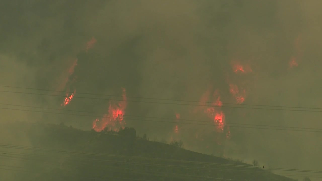


DENVER — At least five homes and 14 outbuildings have been lost to the Lee and Elk fires burning near Meeker in Rio Blanco County, officials said during a news conference Tuesday.
Three of those five homes and 12 of those 14 outbuildings were charred in the 120,650-acre Lee Fire — now Colorado's fifth-largest wildfire in history — after it exploded in size since it first ignited on Aug. 3, according to Rio Blanco County Sheriff Anthony Mazzola. The remaining homes and outbuildings have been lost to the Elk Fire, which is burning southeast of Meeker.
The update from Mazzola and other county and state fire officials came as crews continue to reinforce lines on the north side of the fire and along Highway 13 to secure structures and other areas at risk from the flames.
After days of extreme fire behavior fanned by drought conditions and low relative humidity, fire officials said earlier Tuesday they expected minimal fire behavior on the northern side of the Lee Fire, with continued extreme fire behavior occurring on the southern portion and high potential for fire spread.
Tuesday morning, fire officials said they had achieved 6% containment of the Lee Fire. In an update Tuesday evening, the containment dropped to 4%.
Fire officials said crews fighting the Elk Fire have also made good progress on that fire, and are currently securing the fireline and making sure all the homes and values at risk are no longer threatened. Tyler Nathe, an operations chief with the Rocky Mountain Area Complex Incident Management Team 3, said fire crews have a "few more days of good, hard work getting everything tucked in and secure up there."
An update Tuesday evening showed containment of the fire had jumped from 30% to 75%.
- Denver7 was in Meeker on Tuesday to hear directly from county and fire officials. You can watch the full news conference in the video player below:
Though the Town of Meeker is no longer under a pre-evacuation status, pre-evacuation notices remain in effect northwest and west of Meeker, with evacuations in effect for residents southwest of town, according to the latest evacuation map from fire officials.
The following road closures are still in effect for residents in Rio Blanco County:
- CLOSED HIGHWAYS: Highway 13 South Highway 13 Closure Area: in both directions between Piceance Creek Road (15 miles north of Rifle)
- RESTRICED TO LOCAL TRAFFIC ONLY COUNTY ROADS: County Road 13 (residents who live in the area).
- CLOSED COUNTY ROADS: County Road 5, 22, 33, 40, 45, 47, 49, 63, 66, 67, 117,127, 129
Over the weekend, the Colorado Department of Corrections (CDOC) announced it had evacuated 179 people in custody from the Rifle Correctional Center in response to the Lee Fire, and those inmates were transferred to other CDOC facilities, officials with the agency said.
"We don't anticipate the Rifle community being impacted, and we're feeling really comfortable with what we have here, but we are planning as a team so that in the unlikely event we do get something that progresses farther south, we're ready for it," said Nathe.
Governor Jared Polis has mobilized the Colorado National Guard to support response efforts for the Elk Fire and Lee fires burning in Rio Blanco County, and has verbally declared a disaster declaration for fires elsewhere in the Western Slope. FEMA has also authorized the use of federal funds to help with firefighting costs for the two fires.
More than 164,000 acres of land have been scorched across Delta, Dolores, Garfield, Grand, Mesa, Moffat, Montrose, and Rio Blanco counties, as well as in parts of eastern Utah.
- Denver7 has created the map below to give you a better idea of where these fires are located:
A sizeable portion of the Western Slope is under extreme drought conditions, with a large swath of the western half of the state experiencing moderate and severe drought, according to the latest data from the U.S. Drought Monitor.
Denver7 is also keeping an eye on wildfires burning elsewhere across the Western Slope. You can find updates from those wildfires below.
Crosho Fire
Size: 300 acres
Containment: 0%
First reported: Aug. 11 at 3:25 pm.
Cause: Under investigation
Location: Crosho Lake in the Routt National Forest in Rio Blanco County
Evacuations 🏠: No evacuations at this time
Pre-evacuations: Residents in the area bordered by County Road 19 to the north, Highway 131 to the east, County Road 13 to the south and the Crosho Lake area to the west are included.
The Crosho Fire is burning immediately adjacent and north of Crosho Lake in the Routt National Forest in Rio Blanco County, fire officials said Tuesday.
While pre-evacuation areas have been established, they are likely to change, so residents are advised to click here to view the latest evacuations/pre-evacuation notices.
An evacuation center has been established at South Routt Elementary School, located at 448 Main St. in Yampa.
Chapman Reservoir Campground and dispersed camping in the Crosho Lake area are closed.
Updates posted to:
InciWeb
Rio Blanco County Sheriff's Office
Elk Fire
Size: 14,549 acres
Containment: 75%
First reported: Aug. 2
Cause: ⚡️
Location: 11 miles east of Meeker
Evacuations 🏠: No current evacuations
Pre-evacuations: No pre-evacuations at this time
The lightning-sparked Elk Fire, first reported on Aug. 2, is burning 11 miles west of Meeker in Rio Blanco County.
The fire remains active and continues to burn in pinyon, juniper, and oak brush fuels across private land, state and federal lands, according to the Rio Blanco County Sheriff's Office.
The fire has destroyed at least one home and four outbuildings.
In a Tuesday update, officials said firefighters made progress securing the fireline along County 8 on the south and in the Beaver Creek drainage on the east. They'll be working all day on securing unburned pockets of fuel, strengthening indirect and containment lines and protecting values at first for both fires.
Aviation resources, including helicopters and drones, will be supporting suppression efforts throughout the day, especially as the smoke clears, they said.
An update Tuesday evening showed containment of the fire had jumped from 30% to 75%.

Governor Jared Polis has mobilized the Colorado National Guard to support response efforts for the Elk Fire and Lee fires in Rio Blanco County, and two Type 1 aircraft will be helping firefighters on the ground with suppression efforts Friday.
The following road closures are still in effect, according to the Rio Blanco County Sheriff's Office:
- CLOSED HIGHWAYS: Highway 13 South Highway 13 Closure Area: in both directions between Piceance Creek Road (15 miles north of Rifle)
- RESTRICED TO LOCAL TRAFFIC ONLY COUNTY ROADS: County Road 13 (residents who live in the area).
- CLOSED COUNTY ROADS: County Road 5, 22, 33, 40, 45, 47, 49, 63, 66, 67, 117,127, 129
The Rio Blanco County Sheriff's Office said a partial closure of the White River National Forest was also in effect due to the fire within the Blanco Ranger District west of and including the Long-Lost Trail system.
Updates posted to:
Elk and Lee Fire Information
Rio Blanco County Sheriff's Office
Lee Fire
Size: 120,650 acres
Containment: 4%
First reported: Aug. 3 at 1 p.m.
Cause: ⚡️
Location: 18 miles southwest of Meeker, Colo.
Evacuations 🏠: County Road 22 (Little Hills) off of County Road 5; at the County Road 76 intersection from County Road 3 to County Road 5; Highway 64 between mile marker 58 and mile marker 67, including those on County Road 127, County Road 129, County Road 66 and Bridgewater Lane
Pre-evacuations: County Road 22 (Little Hills) off of County Road 5, as well as for residents along County Road 33
Tuesday morning, fire officials said they had achieved 6% containment of the fire. In an update Tuesday evening, the containment dropped to 4%.
Updates posted to:
Elk and Lee Fire Information
Rio Blanco County Sheriff's Office
Oak Fire
Size: 75 acres
Contained: 47%
First reported: Aug. 10
Cause: Structure fire
Location: Archuleta County west of Pagosa Springs
Evacuations 🏠: Elk Park subdivision, including Elk Park, as well as Aspen Springs. (Mandatory evacuations will expire at noon Wednesday)
Pre-evacuations: No pre-evacuations at this time
At least one small barn, one pump house, one pergola, one carport, and a camper trailer have sustained significant damage from the Oak Fire burning west of Pagosa Springs, according to fire officials.
No homes have been identified as damaged or lost to the fire, officials said, but Gov. Polis has declared a disaster emergency, which frees up state and federal resources, for this fire. Fire officials said Tuesday that the fire, at this time, has cost $2 million.
Evacuees were told to evacuate to Pagosa Springs High School, and a hotline has been opened for those looking for additional information; the number to call is (970-422-7084).
On Tuesday, the Archuleta County Sheriff's Office said all mandatory evacuations will be lifted at noon Wednesday.

On Monday, the Pagosa Ranger District issued a temporary closure of the following roads as a safety precaution:
- Lower Turkey Springs Road (NFSR 629)
- Newt Jack Road (NFSR 919)
- Brockover Mesa Road (NFSR 919)
- Turkey Springs Trail System East of Lower Turkey Springs Road
The Forest Service advised people to avoid these roads until the road closures are lifted.
The La Plata Electric Association (LPEA) has shut down power to about 192 homes due to the fire.
Updates posted to:
Archuleta County Sheriff's Office
Peninsula Fire
Size: 17 acres
Containment: 80%
First reported: Aug. 8
Cause: ⚡️
Location: Specie Mesa (M44 Road) South of Highway 145, between Norwood and Placerville, Colo.
Evacuations 🏠: No evacuation orders at this time
Pre-evacuations: Laughing Dog and Peninsula subdivisions
The lightning-sparked Peninsula Fire, first reported July 31, is burning south of Highway 145 between Norwood and Placerville in San Miguel County.
The San Miguel County Sheriff’s Office reported Friday that the Peninsula Fire was 80% contained, with full containment expected within the next 72 hours, depending on weather and fire behavior.

Updates posted to:
San Miguel County Sheriff's Office
West Slope Fire Info
Stoner Mesa Fire
Size: 6,618 acres
Containment: 0%
First reported: July 28
Cause: ⚡️
Location: 20 miles northeast of Dolores
Evacuations 🏠: No current evacuations
Pre-evacuations: No pre-evacuations at this time
The lightning-sparked Stoner Mesa Fire, first reported on July 28, is burning west of Telluride inside the San Juan National Forest in Dolores County.
In a Tuesday update, fire officials said crews worked all of Monday to hold lines in the face of strong northerly winds and aggressive fire behavior, which caused the fire to jump to nearly double in size to over 6,600 acres. Much of that growth as near the western edge, where winds pushed fire south along Stoner Creek and up areas of Taylor Mesa, including Big Hell and Little Hell Canyons, fire officials said.
Firefighters will implement measures designed to keep the fire out of the Highway 145 and County Road 38 corridors on Tuesday, and continue to focus on protecting structures and communities in those corridors.

The San Juan National Forest has implemented a fire area closure in the vicinity of Taylor and Stoner Mesas for the safety of firefighters and the public, fire officials added.
Updates posted to:
Stoner Mesa Fire Information
USDA Forest Service Facebook page
InciWeb
Turner Gulch Fire
Size: 29,068 acres
Contained: 51%
First reported: July 10
Cause: ⚡️
Location: 8 miles northeast of Gateway, Colo.
Evacuations 🏠: No evacuation orders at this time
Pre-evacuations: All private lands in the Big Creek and Divide Forks Campground Evacuation Zones, including private inholdings in the Uncompahgre National Forest from Forest Road 406 to 409 (seen as the Cold Springs Evacuation Zone on evacuation maps), as well as all private in-holdings in the Ute Creek Evacuation area, which includes areas in the Uncompahgre National Fores.
The Turner Gulch Fire, burning off Highway 141 northeast of the town of Gateway in Mesa County, has burned more than 28,000 acres. Seventeen crews, 26 engines, 26 heavy equipment, and 5 helicopters are battling the blaze, totaling 668 firefighters in all.
In a Tuesday update, fire officials said burning operations are being conducted in the southern area of the fire along the 416.1A trail with plans to connect to the 608 trail in the 2023 Cow Creek prescribed fire area
Officials said crews completed fire line along the Niche Road to the Ute Creek Trail along the west side of the fire

Niche Road is closed due to unsafe conditions, and Divide Road remains closed for safe and operational access. People who need help with sheltering large animals should contact (970) 778-0161 to be connected with options and resources.
No injuries have been reported, and no structures have been lost.
Updates posted to:
InciWeb
Mesa County Sheriff’s Office Facebook
Upper Colorado River Interagency Fire Management Unit Facebook
Twelve Fire
Size: 4,287 acres
Contained: 80%
First reported: Aug. 6
Cause: Unknown
Location: 18 miles west of Maybell, Colo.
Evacuations 🏠: No evacuation orders at this time
Pre-evacuations: No pre-evacuations at this time
The Twelve Fire burning in Moffat County has grown to more than 4,000 acres in size as it continues to burn near Highway 40. However, on Sunday, officials announced that the fire had been downgraded to a Type 4 incident.
No homes have been damaged or destroyed so far, but two outbuildings, a shed and an outhouse, have been lost, deputies said in an update on Aug. 7.
In an update Monday, BLM officials said that due to cooler temperatures and lighter winds, considerable progress has been made on containment and resources have been released to support other fire activity.

Efforts for Twelve Fire Monday will support mop-up and ensure the current perimeter is secure, officials added. Stage 2 fire restrictions remain in effect county-wide.
The cause of the fire is not known at this time.
Though Highway 40 is back open (albeit with speed reductions still in place), Deer Lodge Road, Campground and Boat Launch are currently closed by the National Park Service. Dinosaur National Monument is also closed.
Updates posted to:
Moffat County Sheriff's Office
WILDFIRES THAT HAVE BEEN FULLY CONTAINED
The 107-acre Coulter Creek Fire, which is burning in Carbondale, was fully contained on Aug. 4, just a day after it was first reported by fire officials from the Carbondale & Rural Fire Protection District. No homes were lost, though one outbuilding was destroyed in the fire. No injuries were reported as a result of the blaze.
Burning in eastern Utah and parts of Montrose County, Colo., the 17,724-acre Deer Creek Fire was fully contained on Aug. 11. On Aug. 8, the Montrose County Sheriff's Office said evacuation orders for Montrose County due do this fire had been lifted.
The Leroux Fire burning 1.5 miles east of Redlands Mesa in Hotchkiss, Colo. remains 90% contained and is 195 acres in size. Fire officials said in their last regular update on Sunday that the expected full containment by the end of the week ending Aug. 15.
While not fully contained, the U.S. Forest Service is no longer providing any updates on the South Rim Fire, which is burning inside Black Canyon of the Gunnison National Park in isolated and inaccessible areas. Fire officials said the burn scar from this fire "could lead to rockfall, mud slides, and debris flows that would pose a serious risk to anyone in the East Portal." Ignited by lightning on July 10, the fire was last reported to be 4,232 acres in size and 52% contained.
The Wright Draw Fire, caused by lightning on July 10, about eight miles northeast of Gateway, grew to 466 acres in size before it was fully contained on Aug. 5. No injuries were reported, and no structures were lost, according to fire officials.
The lightning-sparked Windy Gap Fire, first reported Aug. 6, burned 30 acres in Grand County and was fully contained on Monday, Aug.11.


Denver7 is committed to making a difference in our community by standing up for what's right, listening, lending a helping hand and following through on promises. See that work in action, in the videos above.