

DENVER — A helicopter assigned to the Derby Fire was involved in an "incident" around 4:10 p.m. Friday, according to the US Forest Service.
The agency said there is an unconfirmed report that the aircraft is in a lake 13 miles northwest of the Eagle County Regional Airport.
The US Forest Service said the helicopter pilot was picked up by another aircraft and flown to Eagle County Regional Airport. The pilot was checked out by emergency medical personnel and had "minor bumps and bruises" but refused further medical attention.
No further details were provided. The National Transportation Safety Board was notified of the crash, according to USFS, but it is unclear if it will respond to the incident.
The lightning-sparked Derby Fire burning about 15 miles north of Dotsero in the White River National Forest continued to grow overnight and now stands at 4,112 acres in size with 0% containment. At least one structure has been lost in the Sugarloaf Mountain area due to the fire, officials said.
Mandatory evacuations and pre-evacuation notices for the Derby Fire are still in effect and can be viewed here.
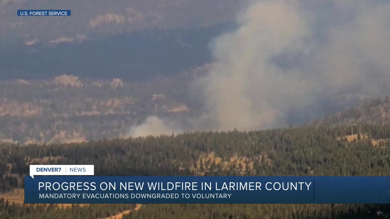
Meanwhile, the Lone Pine Fire, which ignited Thursday west of Red Feather Lakes and south of Deadman Road, was 75% contained by Friday morning, according to the U.S. Forest Service. It has burned 2.5 acres so far. A cause has not been determined.
Denver7 is tracking several other wildfires on Colorado's Western Slope. Below is a summary of those fires, containment amounts and where residents can learn more details.

Size: 137,758 acres
Containment: 80%
First reported: Aug. 2
Cause: ⚡️
Location: 18 miles southwest of Meeker
Evacuations 🏠: For the most up-to-date evacuation map, click here.
Pre-evacuations: For the most up-to-date pre-evacuation map, click here.
The lightning-sparked Lee Fire, first reported on Aug. 2, is burning 18 miles southwest of Meeker in Rio Blanco County.
Three homes and 12 outbuildings have burned so far in the Lee Fire, according to officials in Rio Blanco County, who said firefighters completed chipping operations on the east flank of the fire.
On Friday, aviation and ground crews will continue the work of cooling down a hot spot along the fire’s edge and improving fire lines.
Also on Friday, the Bureau of Land Management rescinded the land closure order for BLM-managed public lands in Garfield County because of the Lee Fire. The rescission is effective immediately because fire and emergency managers have determined the area is safe.
A partial closure of the White River National Forest is still in effect due to the fire within the Blanco Ranger District west of and including the Long-Lost Trail system.
Updates posted to:
Elk and Lee Fire Information
Rio Blanco County Sheriff's Office
InciWeb

Size: 2,072 acres
Containment: 57%
First reported: Aug. 11 at 3:25 pm.
Cause: Unknown
Location: Routt National Forest in Rio Blanco County
Evacuations 🏠: No evacuations at this time
The Crosho Fire continues to burn in the Routt National Forest but has seen no growth since the weekend, according to the latest update from fire officials.
Sixty-seven structures continue to be threatened by the fire, according to the Wyoming Type 3 Incident Management Team, but none have burned as of Friday.
In a Friday update, fire officials said the eastern perimeter of the fire has been contained. Mop-up operations, supported by water, were progressing to the north and west of the fire, where crews were extinguishing pockets of remaining heat.
There are currently no pre-evacuations or evacuation orders for the fire, according to the latest map from the Routt County Office of Emergency Management.
Closures remain in effect for the following roads:
- Intersection of Routt County Road 15 and Routt County Road 17
- Intersection of Routt County Road 25 and Routt County Road 132A
- Rio Blanco County Road 8 (Dunckley Pass) closed at the intersection of Rio Blanco County Roads 8 and 19
Updates posted to:
InciWeb
Crosho Fire Information
Rio Blanco County Sheriff's Office

Size: 10,186 acres
Containment: 32%
First reported: July 28
Cause: ⚡️
Location: 5 miles west of Rico in the San Juan National Forest
Evacuations 🏠: No current evacuations
The west side of the Stoner Mesa Fire, near the Stoner Creek drainage, continues to be most active, fire officials said in an update Friday, adding work will continue to improve the fireline and will conduct strategic firing operations, as conditions allow, to remove fuels between the line and the canyon rim.
A community meeting is being planned for Sunday, Aug. 24, in Dolores, but no details about when or where it'll be have been released yet.
To sign up for Dolores County emergency alerts, click here. To sign up for Montezuma County emergency alerts, click here.
Updates posted to:
Stoner Mesa Fire Information
USDA Forest Service Facebook page
InciWeb

Size: 31,699 acres
Contained: 88%
First reported: July 10
Cause: ⚡️
Location: 8 miles northeast of Gateway in Mesa County
Evacuations 🏠: All evacuation orders have been lifted
In a Friday update, fire officials said suppression repair on area roads was completed Thursday.
Firefighters were also making progress on securing the fireline on the southeast perimeter of the fire, aided by water-handling equipment based out of Big Creek Reservoir.
The Bureau of Land Management has revised its closure area. The same closure area remains in effect for the Grand Mesa, Uncompahgre, and Gunnison (GMUG) National Forests, fire officials said.
Updates posted to:
InciWeb
Turner Gulch Fire Info.
Upper Colorado River Interagency Fire Management Unit Facebook
Mesa County Sheriff's Office page on Facebook

Blue Ridge Fire
Size: 25 acres
Containment: 100%
First reported: Aug. 15
Cause: Under investigation
Location: La Plata County
Notes: All evacuation and pre-evacuation orders lifted on Aug. 18.
Oak Fire
Size: 75 acres
Contained: 78% (as of last update on Aug. 13)
First reported: Aug. 10
Cause: Structure fire
Location: Archuleta County west of Pagosa Springs
Notes: The Archuleta County Sheriff's Office said two suspects have been arrested in connection with an illegal burn that started this fire. The suspects have been identified as Sergio Alaniz Jr., 41, and Ross Heirigs, 60. They were arrested on charges of fourth-degree arson.
Peninsula Fire
Size: 17 acres
Containment: 80% (as of last update on Aug. 10)
First reported: Aug. 8
Cause: ⚡️
Location: South of Highway 145, between Norwood and Placerville
Yellowjacket Fire
Size: 29 acres
Contained: 40% (as of last update on Aug. 16)
First reported: Aug. 15
Cause: Unknown
Location: Northeast of Meeker
Deer Creek Fire
Size: 17,724 Acres
Containment: 100%
First reported: July 10
Cause: Under investigation (as of last update on Aug. 12)
Location: Eastern Utah and Montrose County (Colorado)
South Rim Fire
Size: 4,232 Acres
Containment: N/A (National Park Service says 100% containment likely will not occur until snowfall, but "fire behavior is limited to smoldering and creeping, and poses very little risk of spread outside the current fire footprint.")
First reported: July 10
Cause: ⚡️
Location: Black Canyon of the Gunnison National Park
Leroux Fire
Size: 195 Acres
Containment: 100%
First reported: Aug. 3
Cause: ⚡️
Location: Delta County
Wright Draw Fire
Size: 466 acres
Containment: 100%
First reported: July 10
Cause: ⚡️
Location: Mesa County
Windy Gap Fire
Size: 30 acres
Containment: 100%
First reported: Aug. 6
Cause: Unknown
Location: Grand County


Denver7 is committed to making a difference in our community by standing up for what's right, listening, lending a helping hand and following through on promises. See that work in action, in the videos above.
