


A strong winter storm is triggering blizzard warnings to northeastern Colorado and will drop more than a foot of snow — up to 18 inches in some places — in the mountains.
The winter storm will reach the Denver metro area by Tuesday morning.
READ MORE: Today's forecast | Live radar | Hourly forecast | Weather alerts
The storm is set to significantly impact the eastern plains via whiteout conditions, road closures and harsh conditions for livestock, according to NWS. Blizzards, with wind gusts up to 50 to 60 mph, are likely over northeastern Colorado as the storm intensifies.
The blizzard warning, which is in effect from midnight Monday through midnight Tuesday, in Sedgwick and Phillip Counties, will also impact the cities of Cope, Last Chance, Crook, Peetz, Otis, Sterling, Akron, Leader, Wiggins, Byers, Goodrich, Deer Trail, Merino, Bennett, Brush, and Fort Morgan, according to the NWS. Northern Lincoln and eastern portions of Elbert County were placed under a blizzard warning Monday night. The storm will drop 4 to 10 inches in these areas. The cities of Stoneham, Briggsdale, Raymer, Pawnee Buttes, and Grover are also under this warning, with 3 to 6 inches of snow possible.
The NWS is recommending drivers to avoid traveling east and northeast of Denver until after the storm passes.

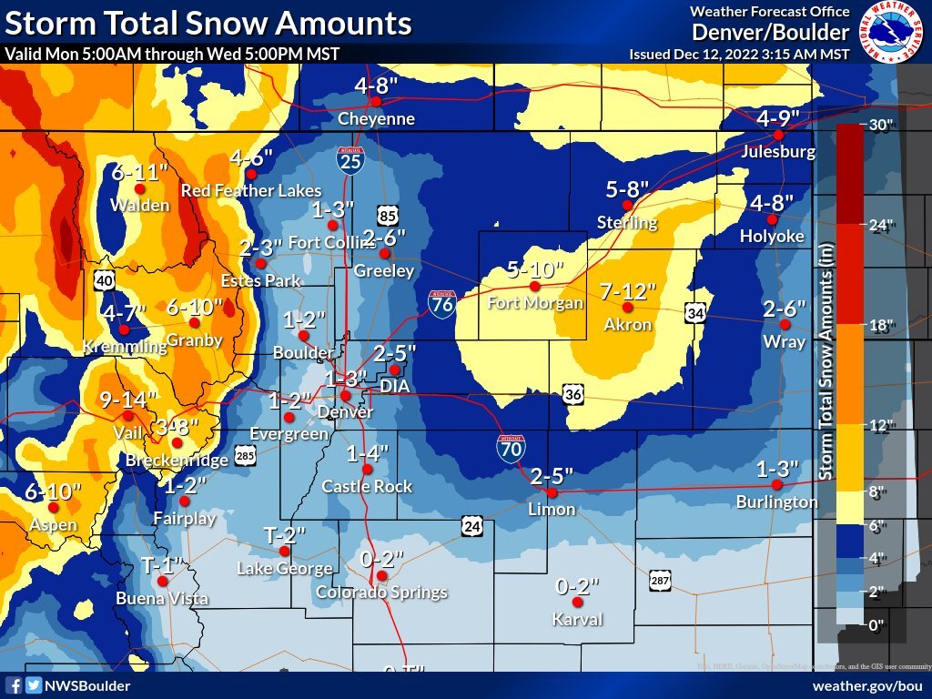
As illustrated in the above graphic, the NWS said the major problems on the northeastern plains are expected beginning between 6 a.m. and noon Tuesday.
The heaviest snow will hit east of Greeley and Denver before it moves toward Akron, Sterling and Fort Morgan.
In addition to snow, strong winds are expected across the eastern plains, with gusts reaching 45 to 60 mph.
Total snow accumulations will start at 6 inches but may reach as high as 18 inches in parts of the northern Colorado mountains, including the Park, northern Gore, and Medicine Bow ranges, as well as Rocky Mountain National Park and Rabbit Ears Pass, the NWS reported. A winter weather advisory remains in place for these areas from 1 p.m. Monday to 5 p.m. Wednesday.
Winter weather advisories are issued when falling snow is accompanied by blowing snow, leading to lower visibility, and therefore, will impact travel conditions.
Here is a roundup of the other winter weather advisories currently affecting Colorado:
- Fort Collins, Denver, Castle Rock, and Greeley. The worst conditions will be east of Interstate 25 and also north of Fort Collins: 9 p.m. Monday to 3 p.m. Tuesday.
- Hugo, Limon, Agate and Matheson: Begins midnight Monday, ends midnight Tuesday
- West Elk and Sawatch mountains: 11 a.m. Monday, ends at 11 p.m. Tuesday
- Gore and Elk Mountains/Central Mountain Valleys: 11 a.m. Monday, ends at 5 p.m. Wednesday
- Elkhead and Park Mountains: 11 a.m. Monday, ends at 5 p.m. Wednesday
- Northwest San Juan Mountains: Ends at 11 p.m. Monday
- Flat Tops: Ends at 5 p.m. Wednesday
- Debeque to Silt Corridor and Central Colorado River Basin: Ends at 5 a.m. Tuesday
- Upper Yampa River Basin: 11 a.m. Monday, ends at 5 p.m. Wednesday
- Central Yampa River Basin: 11 a.m. Monday, ends at 5 p.m. Wednesday
- La Garita Mountains above 10,000 feet: Ends at 11 p.m. Monday
- Western Mosquito Range and eastern Sawatch Mountains above 11,000 feet: 11 a.m. Monday, ends at 5 a.m. Wednesday
- Lake County below 11,000 feet and western Chaffee County between 9,000 and 11,000 feet: 11 a.m. Monday, ends 5 p.m. Tuesday
A winter storm warning is in effect until 11 p.m. for the southwest San Juan Mountains and eastern San Juan Mountains above 10,000 feet, according to the NWS; for the Elkhead and Park Mountains until 5 p.m. Wednesday. Winter storm warnings mean that heavy snow is occurring or will develop soon.
Looking farther west, the NWS out of Grand Junction said the winter storm will start affecting communities Monday afternoon. The storm will bring temperatures that are about 10 degrees below normal and snow-packed and icy roads.
This storm is also bringing an increase in avalanche danger across the state. An avalanche watch is in effect for the northern Front Range, Elkhead and Park Mountains, with "very dangerous" conditions developing by Tuesday morning, according to the Colorado Avalanche Information Center. A watch is also in place for the Medicine Bow Range, Never Summer Range, and Rocky Mountain National Park starting Tuesday morning through Wednesday.
Click here to read more about the avalanche risks this week in Colorado.
Temperatures will stay cool through the extended forecast. Monday may end up being the warmest day across the next 10 days, according to the NWS.