


DENVER — A storm headed to Colorado this week could bring Denver's first measurable snow and may drop a foot of snow in parts of the high country. After midnight, changes will start in the mountains with some late snowfall in the high country.
Denver7 has issued a Weather Action Day for the upcoming storm.
This system will weaken as it stretches over the mountains and into the Front Range.
"Even so, there's nothing to stop it from at least a little rain changing to snow on the plains," the NWS report reads, noting this will happen mostly Thursday overnight into Friday as temperatures cool.
So, how much snow could the Front Range see? NWS acknowledges that that is still a bit up in the air, with some models calling for less than an inch and others calling for up to 3 or 4 inches.
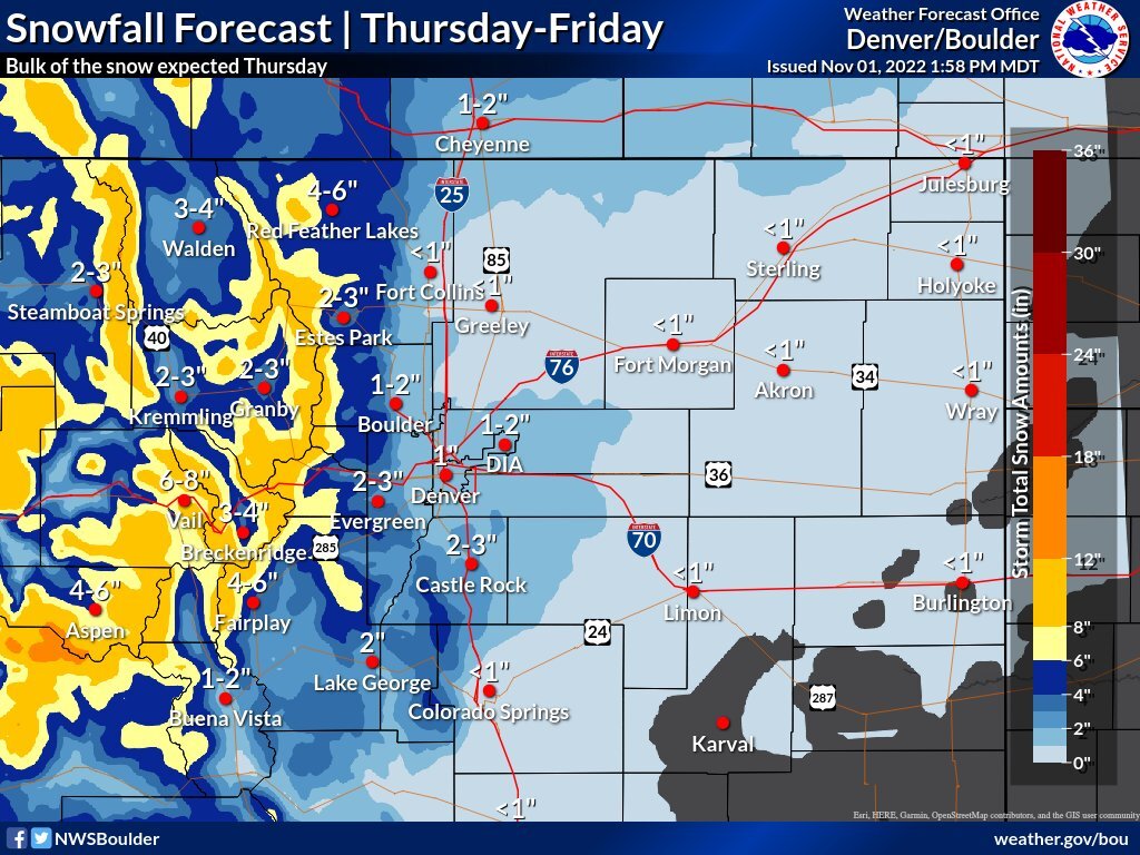
Meanwhile, the mountains will see "a decent period of moderate and perhaps briefly heavy snow" Thursday afternoon and evening, NWS said. Residents and visitors in the higher mountains should expect weather advisories. If a band of snow stays still long enough in this storm, it could drop more than a foot of snow, NWS said.
NWS said the confidence in the mountain snow forecast is considered high, and is considered medium for the lower elevations.
A winter weather advisory is already in place for the Elkhead and Park Mountains, Gore and Elk Mountains and west Elk and Sawatch Mountains starting at midnight Wednesday through 6 a.m. Friday, with snow accumulation totaling 6-12 inches. Other advisories are in effect for the northwest San Juan Mountains, Grand and Battlement Mesas, Flat Tops, and Uncompahgre Plateau from midnight Wednesday through 6 a.m. Friday.
A winter weather advisory will affect the La Garita Mountains and western Mosquito Range and east Lake County from midnight Wednesday through Thursday evening.
The Sangre de Cristo Mountains could see 4 to 12 inches of snow and are under the same advisory from midnight Wednesday until an undetermined time Thursday. Wind gusts in these mountains may reach 45 mph, the NWS reported.
This storm likely won't have much of an impact on the roads below 7,000 feet for the first few hours, with some slush and possible ice in wetter and colder areas after rush hour in Denver Thursday evening, according to the NWS.
The system will bring another shot at the first measurable snow of the season for several locations along Interstate 25.