


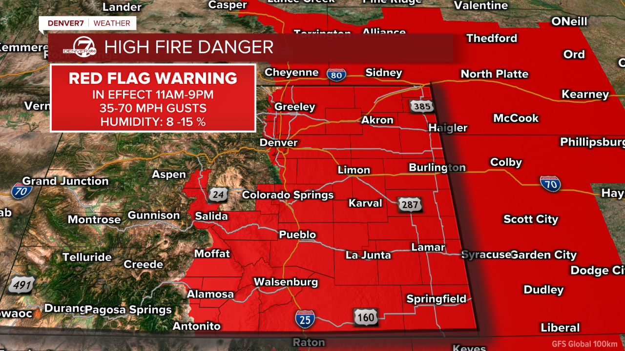
Warm, dry and extremely windy conditions on Saturday have increased the risk of fire spread across much of the eastern half of Colorado, including the urban corridor.
Gusts are expected to reach between 60-70 mph Saturday afternoon before the winds die down and a cold front moves in. A map of Saturday's red flag warning is below.
Denver7 is tracking the latest on Saturday's wind speeds, damage and other impacts to Coloradans in our live weather blog below.

LINKS: Closings and Delays | Latest forecast | Radars | Traffic | Weather Page | 24/7 Weather Stream
8:05 p.m. | Power outage update | Here is the current standing for power outages:
- Xcel Energy - 6,980 customers
- United Power - 799 customers
- CORE Electric - 798 customers
- Poudre Valleuy REA - 5 customers
6:59 p.m. | Small grassfire update | West Metro Fire says the fire is under control and is mopping it up. It burned about two acres.
6:48 p.m. | Small grassfire | West Metro Fire says it is responding to a small grass fire involving several trees off I-70 near Harlan Street. There is heavy smoke over I-70 in that area.
6:15 p.m. | Weather update | The NWS said winds "have been slow" to leave the foothills this afternoon, but are moving east into the lower elevations of Boulder and Jefferson counties.
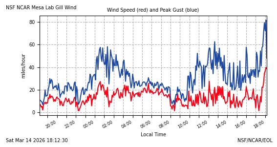
A wind gust around 82 mph was recorded at the NCAR Mesa lab in Boulder.
The strongest wind for these locations is expected between 8-9 p.m. Saturday.
5:14 p.m. | Xcel Energy updates | Xcel Energy is prepping hundreds of crew members to inspect power lines and restore power following today's strong winds.
Outages for some customers may extend through the weekend, the company said.
Extreme fire weather conditions are expected to continue this evening. Power outages are still possible.
4:28 p.m. | Latest from National Weather Service | Critical fire weather will continue into the evening on the plains. A cold front will arrive near midnight.
Snow in the mountains will lead to difficult travel conditions through Sunday morning.
2:17 p.m. | Resources in Boulder | A resource center is available for Xcel Energy customers impacted by the power shutoffs today. It is set up at the North Boulder Recreation Center at 3170 Broadway in Boulder. It will stay open until 6 p.m.
The center will have water, snacks, and charging equipment.
The following charging stations are also available around Boulder County:
- North Boulder Recreation Center (3170 Broadway) with Xcel Charging Stations and Red Cross support from 2 to 6 p.m.
- Superior Community Center (1500 Coalton Road)
- Louisville Library (915 Spruce St.) and Lousiville Recreation Center (900 Via Appia Drive)
- Nederland Community Center (750 CO-72) and also available as a warming center
2:15 p.m. | United Power outages | United Power says it has 167 outages right now, impacting about 4,000 customers.
12:05 p.m. | Update from National Weather Service | The NWS is reiterating its warning about strong winds up to 70 mph for the base of the foothills between 2-5 p.m. Saturday.
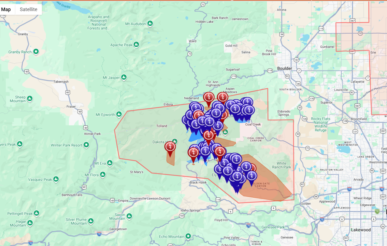
11:14 a.m. | Xcel Energy will implement PSPS | The company said it will implement a Public Safety Power Shutoff starting around 2 p.m. Saturday. It will impact 18,000 customers in Boulder (14,408 customers) and Jefferson (3,403 customers) counties, the company said in a press release.

"Please note, due to anticipated high winds, outages could take place outside of areas impacted by a PSPS, impacting restoration times," Xcel Energy said. "Restoring outages from a significant weather event or PSPS may take several hours to several days. This is because crews must inspect power lines and repair damage before they can be safely re-energized."
Xcel Energy had announced Friday that a PSPS was likely on Saturday.
To see if you will be impacted by Xcel Energy's PSPS, click here and enter your address.
10:27 a.m. | Highway 93 closure | The Jefferson County Sheriff's Office will close Highway 93 between 64th Avenue and Highway 72 around 2 p.m. Saturday due to expected high winds.
10:18 a.m. | Estes Park power outage | The Town of Estes Park said its crews are responding to a "large power outage." The exact number of customers without power was not available, but the town released the below map showing the outage area.

10:16 a.m. | CORE Cooperative update | CORE has no public safety power shutoff events planned for Saturday. However, alternate relay settings, or ARS, are engaged for most of its service area.
ARS react to any fault, like a tree falling on a line, and will limit the line to one attempt to restore. If the fault is still present, it will cut the power to that line. Learn more about it here.
The company said crews are currently on standby.
9:17 a.m. | Xcel Energy update for Golden | Xcel Energy has updated their map for their Public Safety Power Shutoff, or PSPS. Based on the map, Golden is no longer included in the potential shutoff area. However, strong winds are still expected and outages may still occur.
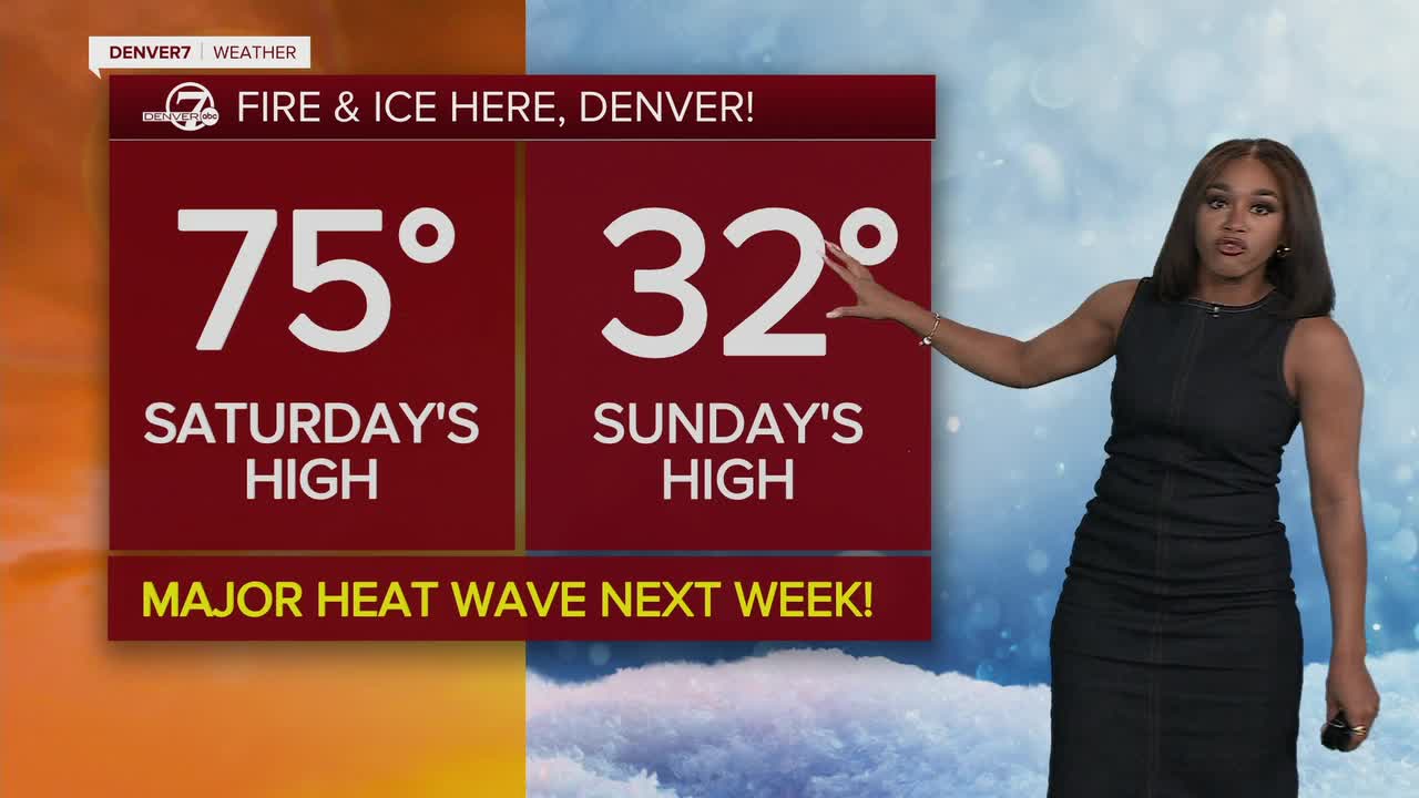
7 a.m. | Denver7 forecast | Denver7's Clara Faith reports that dangerous fire weather conditions are expected across eastern Colorado before a sharp cold front moves late Saturday night into Sunday morning. Much of the eastern half of the state is under a red flag warning.
A red flag warning is in effect from 11 a.m. to 9 p.m. Saturday across the Denver metro area, the urban corridor, and much of the eastern plains. Winds are expected to blow between 20 and 35 mph, with gusts up to 70 mph.
By Saturday evening, a strong cold front will move south through the state, bringing a major change in conditions.
Read the rest of her forecast for the weekend here, or watch it in the video below
5:33 a.m. | Update from National Weather Service | The NWS out of Boulder says Saturday will bring widespread critical fire weather for lower elevations, with elevated concerns in high mountain valleys. Gusts will reach 40 to 60 mph, with the strongest ones near the base of the foothills. Gusts may reach up to 70 mph between 2 p.m. and 5 p.m. there.
Tonight, a cold front will move in, bringing sub-freezing temperatures and strong winds and light snow to lower elevations. The mountains may see heavy snow and whiteout conditions Saturday evening.
Temperatures bounce back up Monday — we could even see record-breaking highs during the week.
5 a.m. | Closed trails | All Boulder County Parks & Open Space trails and open space areas west of Highway 36 are closed on Saturday due to high wind and extreme fire danger.
Denver7's Claire Lavezzorio spoke with authorities who explained how they had reached that decision.
Watch her report on their warning from Friday evening in the video below.
The office also posted online saying residents should "expect dangerous winds, extreme fire risk, and likely power outages. Prepare for possible outages up to 48 hrs. Charge devices, secure outdoor items, avoid sparks, and sign up for emergency alerts at http://bocoalert.org."
5 a.m. | Latest from Xcel Energy | The company is warning residents about a likely Public Safety Power Shutoff (PSPS) on Saturday along the Front Range.
As of now, this is planned for 2 p.m. and may impact about 18,000 customers in Boulder and Jefferson counties.
Conditions are expected to improve between 5 p.m. and 6 p.m.
To see if you could be impacted by Xcel Energy's PSPS, click here and enter your address.
Click here to watch the Denver7 live weather stream.