


DENVER — This winter and spring have produced Colorado’s worst snowpack on record, often measured via weather stations throughout the high country known as SNOpack TELemetry or SNOTEL stations.
Over the last few years, a new kind of complimentary measurement has been taking off — literally.
What started as a NASA Jet Propulsion Lab research project became Airborne Snow Observations (ASO), a company that flies small planes over the mountains to measure the snowpack. Starting in 2015, a joint effort with the state began to deploy the technology and put it to work.
Denver7 got a look at the technology last year.
PREVIOUS COVERAGE: Airborne lasers are measuring Colorado's snowpack, and the technology is taking off
The planes use light detection and ranging (LiDAR) systems to measure the depth of the snowpack across an entire basin, as well as spectrometers that measure how reflective the snow is to determine how fast it is melting.
“The holistic perspective is an important one,” ASO Co-founder and Chief Technology Officer Jeffrey Deems said. “And by that I mean not just the full basin perspective on the snowpack, but how that snowpack evolves with our changing forests, the subsurface hydrology, soil moisture and groundwater. All of this adds up to what our managers and what we ultimately see in our rivers, behind our dams and in our reservoirs and in our taps.”
Through the Colorado Airborne Snow Measurement (CASM) program, ASO works with more than 100 water management partners ranging from small irrigation districts to large utilities like Denver Water. Deems said the more nuanced data helps those groups decide how to manage reservoirs or water restrictions.
Deems, who lives in Carbondale, said ASO’s flights cover 16 watersheds in Colorado.
“The full basin perspective is really showing us that there's parts of the watershed that have more snow than others, and that information can really help managers on the ground anticipate what parts of their watershed or what diversion structures or what reservoirs are going to have better inflow versus other parts of the basin,” Deems explained. “That granularity can really help them out come operations time, now."
“The less [water] you have, the more you need to know about it,” he added.
Broader perspective 'actually even more dire'
Deems said this year, ASO had to move flights up earlier than usual because the snowpack peaked early and began to rapidly melt. He said ASO did 18 survey flights in just one week in March.
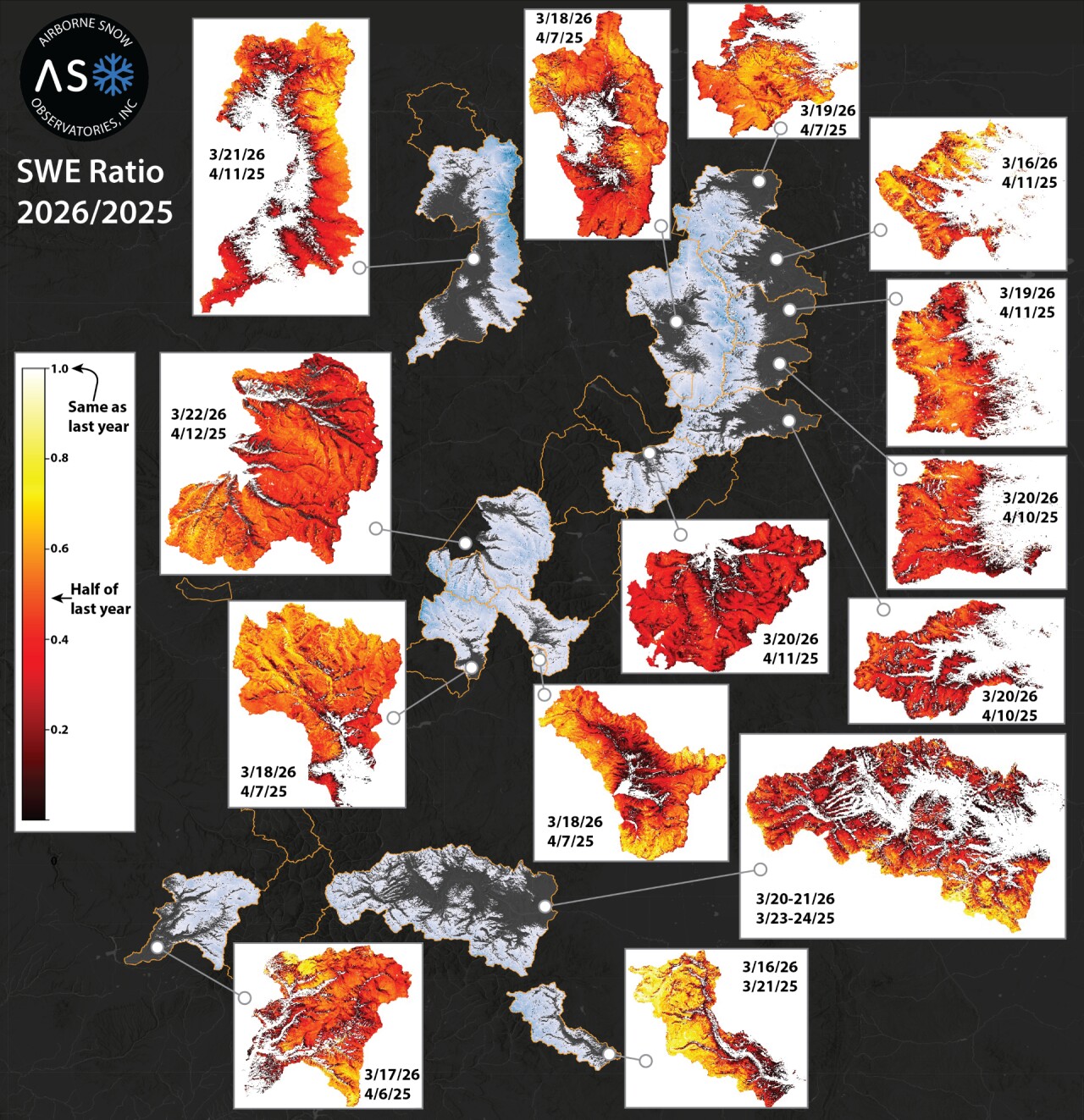
Data from those flights show the huge drop-off in snowpack this year compared to last.
- Watch the full story in the video player below.
“In some cases, the full basin perspective is actually even more dire than what we're seeing from the [SNOTEL] station network this time of year,” Deems said. “With early melt, those stations are still protected in their little forest pockets and aren't melting as fast as the more open areas. So we're seeing perhaps faster declines in the snowpack, and less overall than the stations would indicate in some areas."
“In other basins, we're seeing that there's still a good bit of high elevation snow up there, similar to last year. So not that last year was a huge runoff year, but in some parts of the watersheds, not quite as dire,” he added.
The airborne observation technology is gaining more continuity in the state, with the CASM network expanding.
“Just last year, a brand new program within the Colorado Water Conservation Board really takes that stakeholder-led effort and creates a state program,” Deems explained. “Having that background of a lot of years of working with these data in different parts of the state really helps with that confidence moving forward, so that folks know how to apply it and how to look to these data in times of crisis, like right now.”
